File:Matthew 2016-10-04 1535Z.jpg
Jump to navigation
Jump to search

Size of this preview: 459 × 599 pixels. Other resolutions: 184 × 240 pixels | 368 × 480 pixels | 588 × 768 pixels | 784 × 1,024 pixels | 1,569 × 2,048 pixels | 7,200 × 9,400 pixels.
Original file (7,200 × 9,400 pixels, file size: 9.89 MB, MIME type: image/jpeg)
Captions
Captions
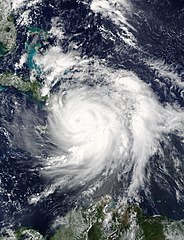
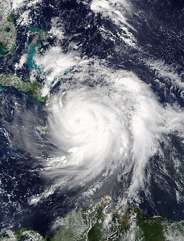
Hurricane Mathew over Haiti
Summary[edit]
| Description |
English: Hurricane Matthew near Haiti on October 4, 2016. |
| Date | |
| Source | Rapid Response - LANCE |
| Author | MODIS image captured by NASA’s Terra satellite |
| Camera location | | View this and other nearby images on: OpenStreetMap |
|---|
Licensing[edit]
| This file is in the public domain in the United States because it was solely created by NASA. NASA copyright policy states that "NASA material is not protected by copyright unless noted". (See Template:PD-USGov, NASA copyright policy page or JPL Image Use Policy.) | ||
 |
Warnings:
|
File history
Click on a date/time to view the file as it appeared at that time.
| Date/Time | Thumbnail | Dimensions | User | Comment | |
|---|---|---|---|---|---|
| current | 19:50, 7 October 2016 | | 7,200 × 9,400 (9.89 MB) | Meow (talk | contribs) | User created page with UploadWizard |
You cannot overwrite this file.
File usage on Commons
The following page uses this file:
File usage on other wikis
The following other wikis use this file:
- Usage on de.wikipedia.org
- Usage on en.wikipedia.org
- Usage on fr.wikipedia.org
- Usage on ht.wikipedia.org
- Usage on hu.wikipedia.org
- Usage on pl.wikipedia.org
- Usage on zh.wikipedia.org