File:Mazama americana distribution.png
跳至導覽
跳至搜尋

預覽大小:572 × 599 像素。 其他解析度:229 × 240 像素 | 458 × 480 像素 | 733 × 768 像素 | 978 × 1,024 像素 | 1,314 × 1,376 像素。
原始檔案 (1,314 × 1,376 像素,檔案大小:124 KB,MIME 類型:image/png)
說明
說明
添加單行說明來描述出檔案所代表的內容
摘要
[編輯]| 描述 |
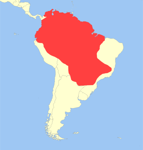
العربية: التوزع الجغرافي للشادن الأحمر
English: Geographic Distribution of Red Brocket (Mazama americana). |
| 日期 | |
| 來源 | Put together by User:Miguelrangeljr using Corel Draw X6. Base map derived from File:Worldmap location NED 50m.svg (Natural Earth Data) Distribution data from the IUCN Red List of Threatened Species (http://www.iucnredlist.org/technical-documents/spatial-data ) Assessed in 2008 by Durate, J.M.B., Vogliotti, A. & Barbanti, M. (http://www.iucnredlist.org/details/29619/0) |
| 作者 | Miguelrangejr & IUCN (International Union for Conservation of Nature); see above |
| 授權許可 (重用此檔案) |
此檔案採用共享創意 姓名標示-相同方式分享 3.0 未在地化版本授權條款。 姓名標示: IUCN Red List of Threatened Species, species assessors and the authors of the spatial data.
|

授權條款
[編輯]
此檔案採用共享創意 姓名標示-相同方式分享 3.0 未在地化版本授權條款。
姓名標示: IUCN Red List of Threatened Species, species assessors and the authors of the spatial data.
- 您可以自由:
- 分享 – 複製、發佈和傳播本作品
- 重新修改 – 創作演繹作品
- 惟需遵照下列條件:
- 姓名標示 – 您必須指名出正確的製作者,和提供授權條款的連結,以及表示是否有對內容上做出變更。您可以用任何合理的方式來行動,但不得以任何方式表明授權條款是對您許可或是由您所使用。
- 相同方式分享 – 如果您利用本素材進行再混合、轉換或創作,您必須基於如同原先的相同或兼容的條款,來分布您的貢獻成品。
檔案歷史
點選日期/時間以檢視該時間的檔案版本。
| 日期/時間 | 縮圖 | 尺寸 | 用戶 | 備註 | |
|---|---|---|---|---|---|
| 目前 | 2014年2月11日 (二) 14:24 | | 1,314 × 1,376(124 KB) | Miguelrangeljr(對話 | 貢獻) | {{Information |Description ={{en|1=Geographic Distribution of Red Brocket (''Mazama americana'').}} |Source =Put together by User:Miguelrangeljr using Corel Draw X6. Base map derived from File:Worldmap location NED 50m.svg (Natural Earth Dat... |
無法覆蓋此檔案。
檔案用途
下列頁面有用到此檔案:
全域檔案使用狀況
以下其他 wiki 使用了這個檔案:
- ar.wikipedia.org 的使用狀況
- arz.wikipedia.org 的使用狀況
- bg.wikipedia.org 的使用狀況
- ca.wikipedia.org 的使用狀況
- ceb.wikipedia.org 的使用狀況
- cs.wikipedia.org 的使用狀況
- de.wikipedia.org 的使用狀況
- en.wikipedia.org 的使用狀況
- es.wikipedia.org 的使用狀況
- eu.wikipedia.org 的使用狀況
- fa.wikipedia.org 的使用狀況
- ga.wikipedia.org 的使用狀況
- id.wikipedia.org 的使用狀況
- ko.wikipedia.org 的使用狀況
- lv.wikipedia.org 的使用狀況
- ms.wikipedia.org 的使用狀況
- pt.wikipedia.org 的使用狀況
- ru.wikipedia.org 的使用狀況
- sv.wikipedia.org 的使用狀況
- uk.wikipedia.org 的使用狀況
- vi.wikipedia.org 的使用狀況
- www.wikidata.org 的使用狀況
- zh.wikipedia.org 的使用狀況