File:Medieval copper alloy buckle (FindID 880090).jpg
Jump to navigation
Jump to search

Size of this preview: 393 × 599 pixels. Other resolutions: 157 × 240 pixels | 315 × 480 pixels | 503 × 768 pixels | 671 × 1,024 pixels | 1,290 × 1,967 pixels.
Original file (1,290 × 1,967 pixels, file size: 618 KB, MIME type: image/jpeg)
Captions
Captions
Add a one-line explanation of what this file represents
Summary
[edit].jpg&action=edit§ion=1)
| Medieval copper alloy buckle | |||
|---|---|---|---|
| Photographer |
Lincolnshire County Council, Adam Daubney, 2018-03-07 12:26:46 |
||
| Title |
Medieval copper alloy buckle |
||
| Description |
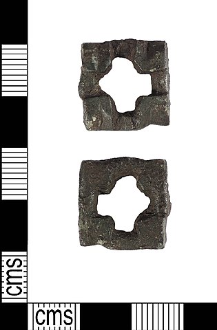
English: An incomplete copper alloy strap link (also known as a strap distributor), of medieval date. It comprises a cast square or sub-rectangular plate, measuring 17mm x 16mm, with a central cruciform aperture, which has very slightly flaring arms. Where each arm meets the rectangular frame there is a sunken field about 4mm wide, between 1mm and 2mm lower than the plate corners. Each of the raised corners has a shaped top, with an angled bevel perhaps making a quatrefoil around the cross aperture. It has a green and dark brown patina.
These strap links come with their corners in a variety of shapes (compare PUBLIC-3F6CF3, NMS-A43F80 and BERK-78B7F3 for examples). See SUR-077856 for an example with some of the strap terminals attached. |
||
| Depicted place | (County of findspot) Lincolnshire | ||
| Date | between 1200 and 1400 | ||
| Accession number |
FindID: 880090 Old ref: PUBLIC-3E2CFB Filename: PUBLIC3E2CFB.jpg |
||
| Credit line |
|
||
| Source |
https://finds.org.uk/database/ajax/download/id/1005108 Catalog: https://finds.org.uk/database/images/image/id/1005108/recordtype/artefacts archive copy at the Wayback Machine Artefact: https://finds.org.uk/database/artefacts/record/id/880090 |
||
| Permission (Reusing this file) |
Attribution License version 2.0 (verified 2 December 2020) | ||
| Object location | | View this and other nearby images on: OpenStreetMap |
|---|
.jpg¶ms=053.189500_N_0000.313855_E_globe:Earth_class:object_type:object__&language=en)
Licensing
[edit].jpg&action=edit§ion=2)
This file is licensed under the Creative Commons Attribution 2.0 Generic license.
Attribution: Lincolnshire County Council
- You are free:
- to share – to copy, distribute and transmit the work
- to remix – to adapt the work
- Under the following conditions:
- attribution – You must give appropriate credit, provide a link to the license, and indicate if changes were made. You may do so in any reasonable manner, but not in any way that suggests the licensor endorses you or your use.
File history
Click on a date/time to view the file as it appeared at that time.
| Date/Time | Thumbnail | Dimensions | User | Comment | |
|---|---|---|---|---|---|
| current | 13:48, 4 December 2018 | | 1,290 × 1,967 (618 KB) | Fæ (talk | contribs) | Portable Antiquities Scheme, LIN, FindID: 880090, medieval, page 18, batch count 52 |
You cannot overwrite this file.
File usage on Commons
The following page uses this file:
.jpg)
.jpg&oldid=710285643)