File:Medieval die (FindID 439374).jpg
Jump to navigation
Jump to search

Size of this preview: 800 × 597 pixels. Other resolutions: 320 × 239 pixels | 640 × 478 pixels | 1,024 × 764 pixels | 1,280 × 955 pixels | 2,391 × 1,784 pixels.
Original file (2,391 × 1,784 pixels, file size: 1.09 MB, MIME type: image/jpeg)
Captions
Captions
Add a one-line explanation of what this file represents
Summary
[edit].jpg&action=edit§ion=1)
| Medieval die | |||
|---|---|---|---|
| Photographer |
West Yorkshire Archaeology Advisory Service, Amy Downes, 2011-04-21 12:11:58 |
||
| Title |
Medieval die |
||
| Description |
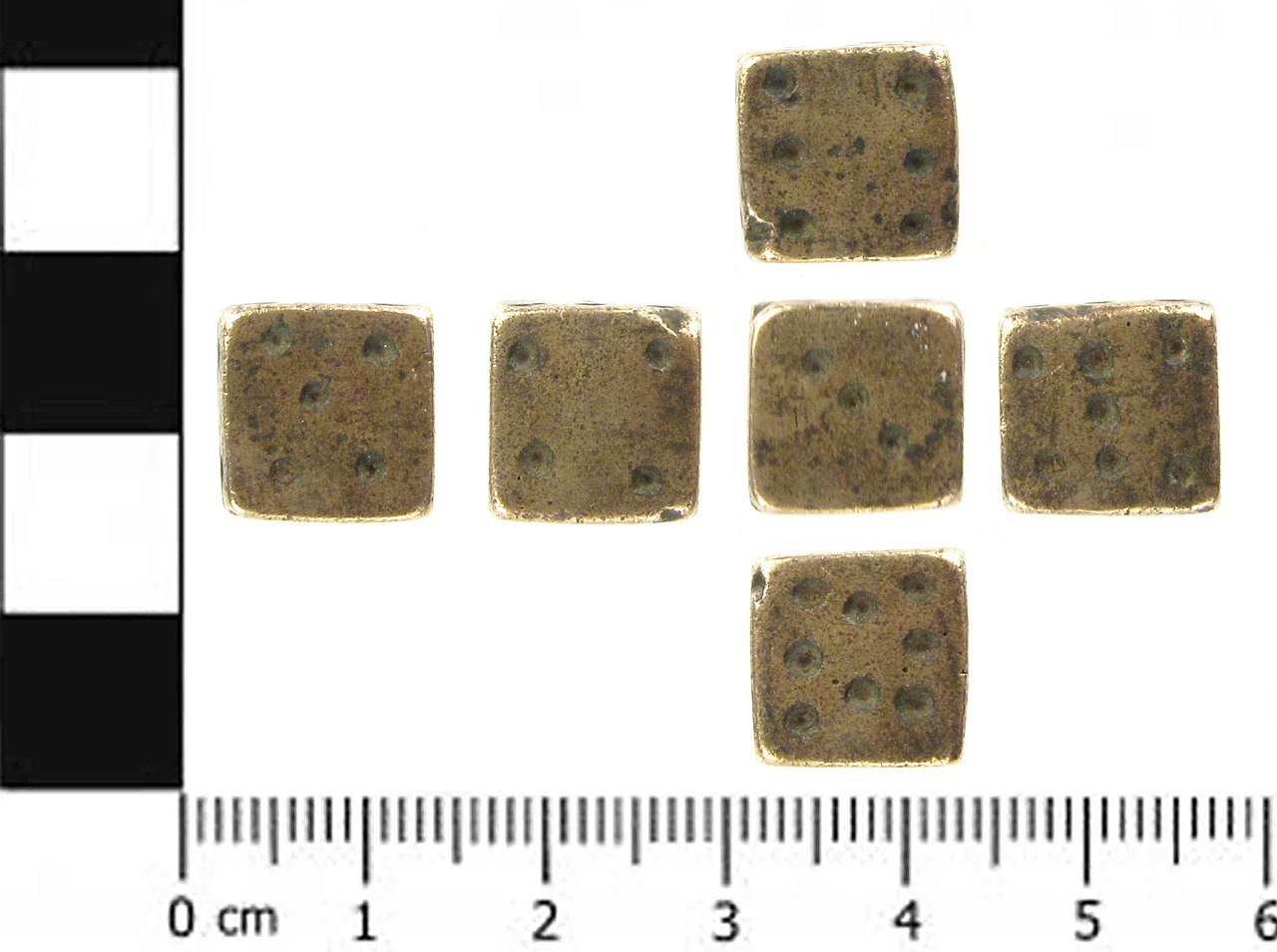
English: A cast, copper alloy die of uncertain date, but probably late medieval, or early post-medieval, dating from 1300-1550, though dice have been used from at least Roman times up to the present day with little change in design. The numbers are, as is usual, represented by punched or drilled dots. Most unusually, this die does not carry the standard range of numbers (one to six), but numbers three to eight; numbers one and two being absent. Opposite faces do not add up to the same number, being 3 and 5, 4 and 7, and 6 and 8 respectively. The die is cubical, being 11.2mm on each side. It weighs 10.73gm. It is not known what game such a die is used for, but modern examples are still available. |
||
| Depicted place | (County of findspot) North Yorkshire | ||
| Date | between 1300 and 1550 | ||
| Accession number |
FindID: 439374 Old ref: SWYOR-D92906 Filename: PAS_1392_dice.jpg |
||
| Credit line |
|
||
| Source |
https://finds.org.uk/database/ajax/download/id/325362 Catalog: https://finds.org.uk/database/images/image/id/325362/recordtype/artefacts archive copy at the Wayback Machine Artefact: https://finds.org.uk/database/artefacts/record/id/439374 |
||
| Permission (Reusing this file) |
Attribution-ShareAlike License | ||
| Object location | | View this and other nearby images on: OpenStreetMap |
|---|
.jpg¶ms=053.713800_N_-001.157910_E_globe:Earth_class:object_type:object__&language=en)
Licensing
[edit].jpg&action=edit§ion=2)
This file is licensed under the Creative Commons Attribution-Share Alike 2.0 Generic license.
Attribution: The Portable Antiquities Scheme/ The Trustees of the British Museum
- You are free:
- to share – to copy, distribute and transmit the work
- to remix – to adapt the work
- Under the following conditions:
- attribution – You must give appropriate credit, provide a link to the license, and indicate if changes were made. You may do so in any reasonable manner, but not in any way that suggests the licensor endorses you or your use.
- share alike – If you remix, transform, or build upon the material, you must distribute your contributions under the same or compatible license as the original.
File history
Click on a date/time to view the file as it appeared at that time.
| Date/Time | Thumbnail | Dimensions | User | Comment | |
|---|---|---|---|---|---|
| current | 13:35, 1 February 2017 | | 2,391 × 1,784 (1.09 MB) | Fæ (talk | contribs) | Portable Antiquities Scheme, SWYOR, FindID: 439374, medieval, page 388, batch North+Yorkshire count 1851 |
You cannot overwrite this file.
File usage on Commons
The following page uses this file:
.jpg)
.jpg&oldid=545033522)