File:Medieval map of Cairo revised.png
Jump to navigation
Jump to search

Size of this preview: 379 × 599 pixels. Other resolutions: 152 × 240 pixels | 303 × 480 pixels | 486 × 768 pixels | 648 × 1,024 pixels | 1,336 × 2,112 pixels.
Original file (1,336 × 2,112 pixels, file size: 1.93 MB, MIME type: image/png)
Captions
Captions
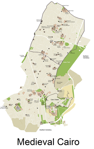
A map of Islamic Cairo and some of its main monuments.
Summary[edit]
| Description |
English: A map of historic Cairo and its monuments, overlaid on the modern road grid.
Changes from original version: fixed name and location errors, and fixed topography in a few key areas where Google Maps misrepresents the actual street layout. (PS: Unfortunately it was accidentally saved in jpeg instead of png during editing, which disturbed the quality of the image slightly on close-up compared to the original version.) |
| Date | |
| Source | Wiki Commons: Medieval map of Cairo.png |
| Author |
Original: Arab Hafez Revisions: Robert Prazeres |
Licensing[edit]
This file is licensed under the Creative Commons Attribution-Share Alike 4.0 International license.
- You are free:
- to share – to copy, distribute and transmit the work
- to remix – to adapt the work
- Under the following conditions:
- attribution – You must give appropriate credit, provide a link to the license, and indicate if changes were made. You may do so in any reasonable manner, but not in any way that suggests the licensor endorses you or your use.
- share alike – If you remix, transform, or build upon the material, you must distribute your contributions under the same or compatible license as the original.
File history
Click on a date/time to view the file as it appeared at that time.
| Date/Time | Thumbnail | Dimensions | User | Comment | |
|---|---|---|---|---|---|
| current | 04:45, 25 November 2019 | | 1,336 × 2,112 (1.93 MB) | R Prazeres (talk | contribs) | User created page with UploadWizard |
You cannot overwrite this file.
File usage on Commons
There are no pages that use this file.
File usage on other wikis
The following other wikis use this file:
- Usage on ar.wikipedia.org
- باب زويلة (القاهرة)
- القاهرة الإسلامية
- وكالة قايتباي
- الأزهر الشريف
- مسجد الحاكم بأمر الله
- حديقة الأزهر
- مسجد الأقمر
- المتحف الحربي المصري
- خان الخليلي
- مسجد ومدرسة صرغتمش الناصري
- قصر الجوهرة
- قلعة صلاح الدين الأيوبي (القاهرة)
- مسجد الإمام الحسين (القاهرة)
- شارع المعز لدين الله الفاطمي
- قصر الأمير بشتاك
- قصر الأمير طاز
- مجموعة محمد بك أبو الذهب
- مسجد السيدة زينب (القاهرة)
- الدرب الأحمر (القاهرة)
- متحف جاير أندرسون
- مسجد جمال الدين يوسف الاستادار
- سور مجرى العيون
- مدرسة وقبة نجم الدين أيوب
- مسجد السيدة نفيسة (القاهرة)
- مسجد الجيوشي (القاهرة)
- مسجد الصالح طلائع
- مسجد السيدة عائشة
- مسجد ومدرسة ابن تغري بردي
- مسجد ومدرسة الأمير خاير بك
- سبيل وكتاب عبد الرحمن كتخدا
- ميدان صلاح الدين
- مسجد السيدة رقية (القاهرة)
- مسجد وسبيل سليمان أغا السلحدار
- بيت السناري
- البيمارستان المؤيدي
- قائمة أسوار وأبواب القاهرة القديمة
- بين القصرين (القاهرة)
- بيت الرزاز
- مسجد الطنبغا المارداني
- مسجد سليمان باشا الخادم
- مسجد ومدرسة سنجر الجاولي
- مسجد ومدرسة ألجاي اليوسفي
- مدرسة أم السلطان شعبان
- مدرسة وقبة تتر الحجازية
- مسجد قاني باي المحمدي
- مسجد وخانقاه الأشرف برسباي (القرافة)
- كنيسة القديسة مريم (حارة زويلة)
- قالب:القاهرة الإسلامية
- باب البرقية
- باب الوزير
View more global usage of this file.