File:Mediterranean Sea political map-fr.svg
跳转到导航
跳转到搜索

此SVG文件的PNG预览的大小:800 × 585像素。 其他分辨率:320 × 234像素 | 640 × 468像素 | 1,024 × 749像素 | 1,280 × 936像素 | 2,560 × 1,872像素 | 2,046 × 1,496像素。
原始文件 (SVG文件,尺寸为2,046 × 1,496像素,文件大小:1.1 MB)
说明
说明
添加一行文字以描述该文件所表现的内容
摘要
[编辑]| 描述 |
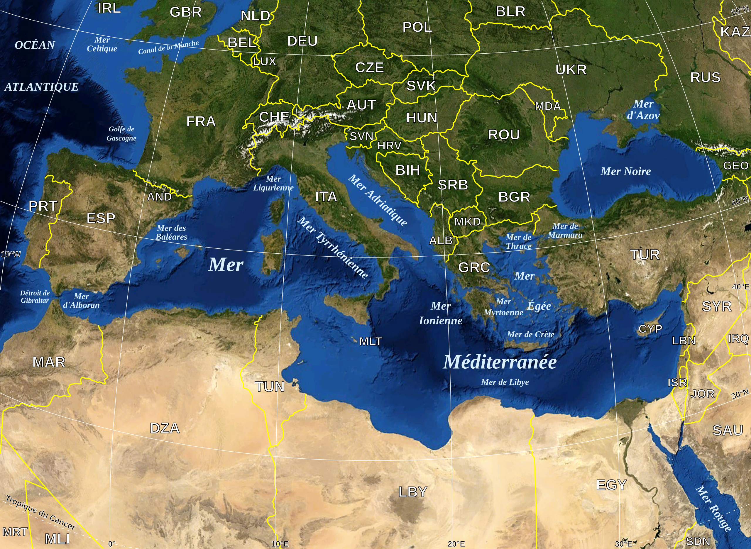
English: Map in French of the Mediterranean Sea, with the borders and the name of the States (except Montenegro, missing) following the ISO 3166-1 Alpha-3 code.
Français : Carte en français de la Mer Méditerranée avec les frontières et les noms des États (manque le Monténégro) suivant le code ISO 3166-1 Alpha-3.
Español: Mapa en francés del Mar Mediterráneo con las fronteras y los códigos de los Estados (menos el Montenegro) segun la norma ISO 3166-1 Alpha-3.
Deutsch: Karte des Mittelmeer, mit Staaten (bis auf Montenegro), ISO 3166-1 Alpha-3 code, und Grenzen, in französisch. |
| 日期 | |
| 来源 |
Own work ; Raster background map : screenshot from NASA World Wind (Public Domain) |
| 作者 | Eric Gaba (Sting - fr:Sting) |
| 授权 (二次使用本文件) |
All rights released |
| 其他版本 |
|
| SVG开发 |


|
This SVG file contains embedded text that can be translated into your language, using any capable SVG editor, text editor or the SVG Translate tool. For more information see: About translating SVG files. |
许可协议
[编辑]
| 本图像属于 w:公有领域 ,因其为 NASA 的 World Wind 卫星地图浏览器的一张截图,且使用了公有领域图层,如 Blue Marble、MODIS、Landsat、SRTM、USGS、GLOBE 等。
|
 |
| This work was previously under Public Domain, or a Free License. It has been digitally enhanced and/or modified. This derivative work has been (or is hereby) released into the public domain by its author, Sting at the French Wikipedia project. This applies worldwide. 在一些国家这可能不合法;如果是这样的话,那么:
|
文件历史
点击某个日期/时间查看对应时刻的文件。
| 日期/时间 | 缩略图 | 大小 | 用户 | 备注 | |
|---|---|---|---|---|---|
| 当前 | 2008年5月19日 (一) 16:11 | | 2,046 × 1,496(1.1 MB) | Sting(留言 | 贡献) | "Tropic of Cancer" label correction |
| 2007年6月21日 (四) 00:56 |  | 2,046 × 1,496(1.09 MB) | Sting(留言 | 贡献) | {{Information |Description=Map in French of the Mediterranean Sea, with the borders and the name of the States following the ISO 3166-1 Alpha-3 code. |Source=Own work ;<br/>Background map : screenshot from NASA World Wind (Public |
您不可以覆盖此文件。
文件用途
以下6个页面使用本文件:
.jpg)
全域文件用途
以下其他wiki使用此文件:
- ar.wikipedia.org上的用途
- fr.wikipedia.org上的用途
- Portail:Mer Méditerranée
- Portail:Turquie
- Portail:Mer Méditerranée/Index thématique
- Liste des poissons de la mer Méditerranée
- Wikipédia:Le Bistro/22 mars 2008
- Utilisateur:Pradigue/Byrsa
- Portail:Moyen-Orient
- Projet:Moyen-Orient
- Projet:Moyen-Orient/Projets connexes
- Portail:Turquie/Portails connexes
- Projet:Moyen-Orient/Portails Connexes
- Échinodermes de Méditerranée
- Nudibranches de Méditerranée
- Cétacés de Méditerranée
- Méduses de Méditerranée
- fr.wiktionary.org上的用途