File:Merseyrail map 2010.svg
Jump to navigation
Jump to search

Size of this PNG preview of this SVG file: 551 × 600 pixels. Other resolutions: 221 × 240 pixels | 441 × 480 pixels | 706 × 768 pixels | 941 × 1,024 pixels | 1,882 × 2,048 pixels | 1,226 × 1,334 pixels.
Original file (SVG file, nominally 1,226 × 1,334 pixels, file size: 735 KB)
Captions
Captions
Add a one-line explanation of what this file represents
Summary[edit]
| Description |
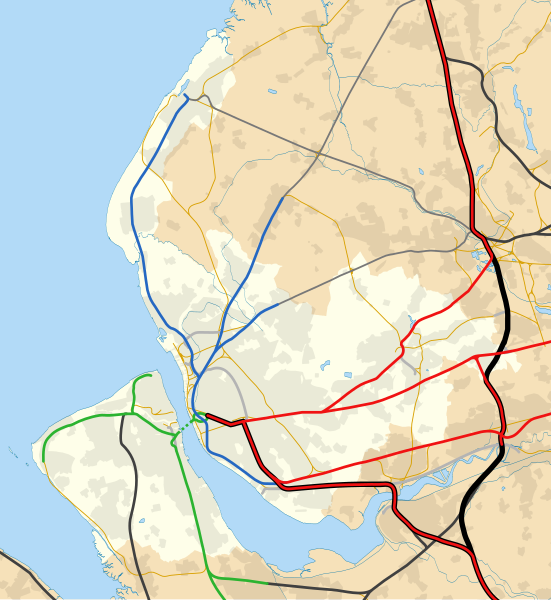
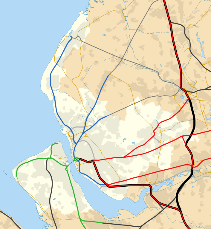
English: Map of Merseyside, England with the following information shown:
Equirectangular map projection on WGS 84 datum, with N/S stretched Geographic limits:
National Rail primary route
National Rail secondary route
National Rail rural route
Goods only
Disused railway |
| Date | |
| Source |
This file was derived from: |
| Author |
|


References[edit]
- (1929) Combined index shewing parishes and the Ordnance Survey of Lancashire archive copy at the Wayback Machine, Ordnance Survey, copy online at Lancashire County Council website accessed 22 July 2012
- Wignall, C.J. (1983), Complete British Railways Maps and Gazetteer from 1830–1981, Oxford Railway Publishing Company, Oxford, ISBN 0 86093 162 5
- (2011) Network Specification 2011 – London North Western archive copy at the Wayback Machine, Network Rail, London, p.24, accessed 23 July 2012
- (1947–1957) Ordnance Survey New Popular Edition maps, copy online at New Popular Edition Maps website, accessed 14 August 2012
- (2009) Merseyrail network map, Merseytravel website, accessed 19 February 2015
Licensing[edit]
This file is licensed under the Creative Commons Attribution-Share Alike 3.0 Unported license.
Attribution: Dr Greg and Nilfanion. Contains Ordnance Survey data © Crown copyright and database right 2010
- You are free:
- to share – to copy, distribute and transmit the work
- to remix – to adapt the work
- Under the following conditions:
- attribution – You must give appropriate credit, provide a link to the license, and indicate if changes were made. You may do so in any reasonable manner, but not in any way that suggests the licensor endorses you or your use.
- share alike – If you remix, transform, or build upon the material, you must distribute your contributions under the same or compatible license as the original.
File history
Click on a date/time to view the file as it appeared at that time.
| Date/Time | Thumbnail | Dimensions | User | Comment | |
|---|---|---|---|---|---|
| current | 20:19, 20 February 2015 | | 1,226 × 1,334 (735 KB) | Dr Greg (talk | contribs) | User created page with UploadWizard |
You cannot overwrite this file.
File usage on Commons
The following 5 pages use this file:
File usage on other wikis
The following other wikis use this file:
- Usage on en.wikipedia.org
- Usage on www.wikidata.org