File:Metro de Santiago.svg
跳转到导航
跳转到搜索

此SVG文件的PNG预览的大小:500 × 600像素。 其他分辨率:200 × 240像素 | 400 × 480像素 | 640 × 768像素 | 853 × 1,024像素 | 1,707 × 2,048像素 | 1,500 × 1,800像素。
原始文件 (SVG文件,尺寸为1,500 × 1,800像素,文件大小:1.17 MB)
说明
说明
添加一行文字以描述该文件所表现的内容
摘要
[编辑]| 描述 |
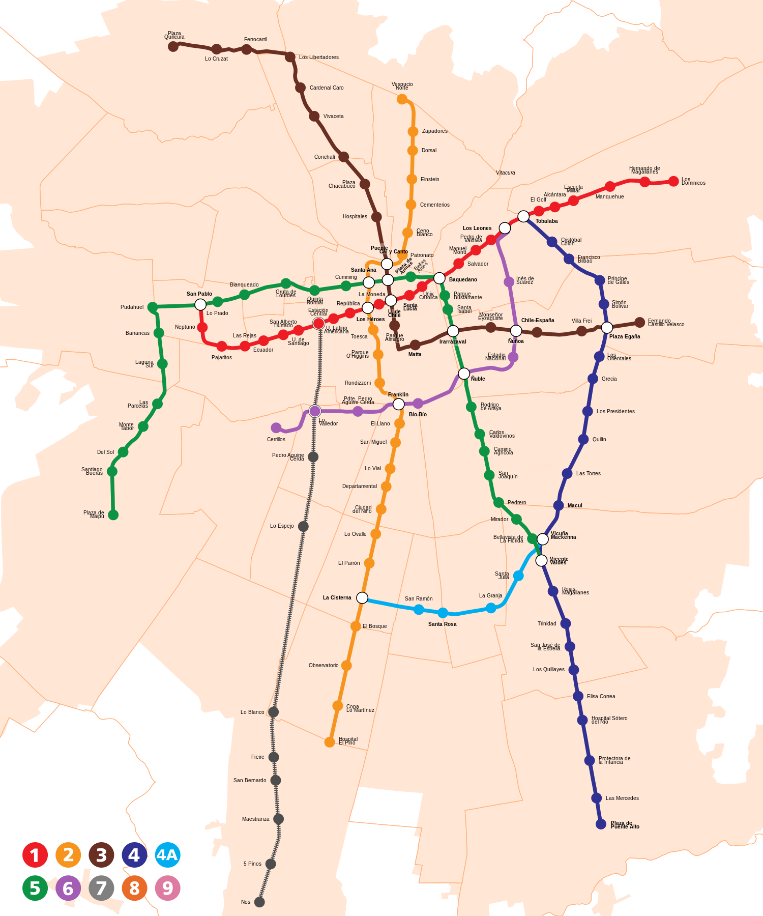
Español: Mapa de líneas y estaciones del Metro de Santiago, Chile. El mapa está a escala. Incluye servicios de tren de cercanías Metrotren. English: Map of lines and stations of the subway of Santiago, Chile (to scale). It includes the Metrotren suburban railway. |
| 日期 | |
| 来源 | |
| 作者 | B1mbo |
| 授权 (二次使用本文件) |
我,本作品著作权人,特此采用以下许可协议发表本作品: 本文件采用知识共享署名-相同方式共享 4.0 国际许可协议授权。
|
| 其他版本 |
 |

.svg)
.svg)
.svg)


文件历史
点击某个日期/时间查看对应时刻的文件。
| 日期/时间 | 缩略图 | 大小 | 用户 | 备注 | |
|---|---|---|---|---|---|
| 当前 | 2023年11月28日 (二) 04:48 | | 1,500 × 1,800(1.17 MB) | B1mbo(留言 | 贡献) | + L2 a San Bernardo |
| 2023年9月25日 (一) 23:54 |  | 1,500 × 1,800(1.17 MB) | B1mbo(留言 | 贡献) | L3 Quilicura inaugurada | |
| 2019年7月19日 (五) 05:59 |  | 1,500 × 1,800(1.2 MB) | B1mbo(留言 | 贡献) | m | |
| 2018年7月9日 (一) 05:38 |  | 1,500 × 1,800(1.19 MB) | B1mbo(留言 | 贡献) | Versión final (agregando nombres de estaciones faltantes). | |
| 2018年7月9日 (一) 05:01 |  | 1,500 × 1,800(1.18 MB) | B1mbo(留言 | 贡献) | m | |
| 2018年7月9日 (一) 04:36 |  | 1,500 × 1,800(1.21 MB) | B1mbo(留言 | 贡献) | Nuevo modelo. Incluyendo nueva área metropolitana, servicio de cercanías y sólo líneas en construcción. | |
| 2018年6月15日 (五) 00:55 |  | 1,000 × 1,200(3.36 MB) | Sfs90(留言 | 贡献) | Mapa subido por Ojo de Sauron presenta copyright por parte de Metro de Santiago, en cambio mapa subido por B1mbo es creación propia con derechos liberados | |
| 2018年6月15日 (五) 00:54 |  | 931 × 899(840 KB) | Ojo de Sauron(留言 | 贡献) | Mapa actualizado | |
| 2018年6月15日 (五) 00:53 |  | 1,000 × 1,200(3.36 MB) | Sfs90(留言 | 贡献) | Reverted to version as of 04:22, 2 January 2018 (UTC) | |
| 2018年6月15日 (五) 00:13 |  | 931 × 899(840 KB) | Ojo de Sauron(留言 | 贡献) | Versión actualizada, proveniente de directamente de Metro, nuevas lineas 8 y 9 + extensión de Linea 4 |
您不可以覆盖此文件。
文件用途
以下38个页面使用本文件:
- Santiago Metro
- Transit maps
- User:Chumwa/OgreBot/Potential transport maps/2017 December 21-31
- User:Chumwa/OgreBot/Potential transport maps/2017 June 1-10
- User:Chumwa/OgreBot/Potential transport maps/2017 November 1-10
- User:Chumwa/OgreBot/Potential transport maps/2018 July 1-10
- User:Chumwa/OgreBot/Potential transport maps/2018 June 11-20
- User:Chumwa/OgreBot/Potential transport maps/2019 July 11-20
- User:Chumwa/OgreBot/Public transport information/2017 December 21-31
- User:Chumwa/OgreBot/Public transport information/2017 June 1-10
- User:Chumwa/OgreBot/Public transport information/2017 November 1-10
- User:Chumwa/OgreBot/Public transport information/2018 July 1-10
- User:Chumwa/OgreBot/Public transport information/2018 June 11-20
- User:Chumwa/OgreBot/Public transport information/2019 July 11-20
- User:Chumwa/OgreBot/Public transport information/2023 November 21-30
- User:Chumwa/OgreBot/Public transport information/2023 September 21-30
- User:Chumwa/OgreBot/Transport Maps/2017 December 21-31
- User:Chumwa/OgreBot/Transport Maps/2017 June 1-10
- User:Chumwa/OgreBot/Transport Maps/2017 November 1-10
- User:Chumwa/OgreBot/Transport Maps/2018 July 1-10
- User:Chumwa/OgreBot/Transport Maps/2018 June 11-20
- User:Chumwa/OgreBot/Transport Maps/2019 July 11-20
- User:Chumwa/OgreBot/Transport Maps/2023 November 21-30
- User:Chumwa/OgreBot/Transport Maps/2023 September 21-30
- User:Chumwa/OgreBot/Travel and communication maps/2017 December 21-31
- User:Chumwa/OgreBot/Travel and communication maps/2017 June 1-10
- User:Chumwa/OgreBot/Travel and communication maps/2017 November 1-10
- User:Chumwa/OgreBot/Travel and communication maps/2018 July 1-10
- User:Chumwa/OgreBot/Travel and communication maps/2018 June 11-20
- User:Chumwa/OgreBot/Travel and communication maps/2019 July 11-20
- File:Metro de Santiago.svg
- File:Metro de Santiago (futuro).svg
- File:Metro de Santiago (futuro, plain).svg
- File:Metro de Santiago (plain).svg
- Template:Santiago Metro
- Category:Maps of Santiago Metro
- Category:Santiago Metro
- Category:Santiago Metro stations
全域文件用途
以下其他wiki使用此文件:
- ar.wikipedia.org上的用途
- be-tarask.wikipedia.org上的用途
- bg.wikipedia.org上的用途
- bn.wikipedia.org上的用途
- cs.wikipedia.org上的用途
- de.wikipedia.org上的用途
- de.wikivoyage.org上的用途
- en.wikipedia.org上的用途
- en.wikivoyage.org上的用途
- eo.wikipedia.org上的用途
- es.wikipedia.org上的用途
- eu.wikipedia.org上的用途
- fa.wikipedia.org上的用途
- fi.wikipedia.org上的用途
- fr.wikipedia.org上的用途
- Métro de Santiago
- Ligne 4 du métro de Santiago
- Tobalaba (métro de Santiago)
- Cristóbal Colón (métro de Santiago)
- Francisco Bilbao (métro de Santiago)
- Príncipe de Gales (métro de Santiago)
- Simón Bolívar (métro de Santiago)
- Plaza Egaña (métro de Santiago)
- Las Torres (métro de Santiago)
- Macul (métro de Santiago)
- Fernando Castillo Velasco (métro de Santiago)
- Los Libertadores (métro de Santiago)
- he.wikipedia.org上的用途
- he.wikivoyage.org上的用途
- id.wikipedia.org上的用途
- is.wikipedia.org上的用途
- it.wikipedia.org上的用途
- ja.wikipedia.org上的用途
- ka.wikipedia.org上的用途
- nl.wikipedia.org上的用途
- no.wikipedia.org上的用途
- pl.wikipedia.org上的用途
- pl.wikivoyage.org上的用途
- pt.wikipedia.org上的用途
- sq.wikipedia.org上的用途
- sv.wikipedia.org上的用途
- th.wikipedia.org上的用途
查看此文件的更多全域用途。