File:Microblade (left margin) (FindID 995391-1096937).jpg
Jump to navigation
Jump to search

Size of this preview: 450 × 600 pixels. Other resolutions: 180 × 240 pixels | 360 × 480 pixels | 576 × 768 pixels | 1,200 × 1,600 pixels.
Original file (1,200 × 1,600 pixels, file size: 639 KB, MIME type: image/jpeg)
Captions
Captions
Add a one-line explanation of what this file represents
Summary[edit]
_(FindID_995391-1096937).jpg&action=edit§ion=1)
| microblade (left margin) | |||
|---|---|---|---|
| Photographer |
Royal Institution of Cornwall, Anna Tyacke, 2020-03-19 13:17:54 |
||
| Title |
microblade (left margin) |
||
| Description |
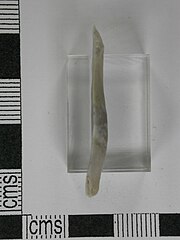
English: A flint micro-blade of the Mesolithic period 34 mm in length, 10.5 mm width and 3 mm in thickness. Both margins on the dorsal face are retouched to create the sharper edges. Part of the bulb of percussion remains on the ventral face at the proximal end with the resulting conchoidal ripples extending across the face to the opposite distal end. No cortex remains so this is a tertiary flake and may be a distance from where it was knapped as a product of the Mesolithic blade industry. The flint is pale grey with bands of darker grey flint so it has been derived from a local beach pebble.
Bond (2004) illustrates groups of very similar micro-blades from the earlier Mesolithic site at Thatcham, Berkshire on p.108, fig.5.92, nos.L49-L53 and the later Mesolithic site of Oakhanger, Hampshire on p.116, fig.5.100, nos.1-3. |
||
| Depicted place | (County of findspot) Devon | ||
| Date | between 9000 BC and 4000 BC | ||
| Accession number |
FindIdentifier: 995391 |
||
| Credit line |
|
||
| Source |
https://finds.org.uk/database/ajax/download/id/1096937 Catalog: https://finds.org.uk/database/images/image/id/1096937/recordtype/artefacts archive copy at the Wayback Machine Artefact: https://finds.org.uk/database/artefacts/record/id/995391 |
||
| Permission (Reusing this file) |
Attribution License version 2.0 (verified 13 November 2020) | ||
| Other versions | FindID 995391 has multiple images: 1096935 1096936 1096937 search | ||
| Object location | | View this and other nearby images on: OpenStreetMap |
|---|
_(FindID_995391-1096937).jpg¶ms=050.976000_N_-004.485820_E_globe:Earth_class:object_type:object__&language=en)
Licensing[edit]
_(FindID_995391-1096937).jpg&action=edit§ion=2)
This file is licensed under the Creative Commons Attribution 2.0 Generic license.
Attribution: Royal Institution of Cornwall
- You are free:
- to share – to copy, distribute and transmit the work
- to remix – to adapt the work
- Under the following conditions:
- attribution – You must give appropriate credit, provide a link to the license, and indicate if changes were made. You may do so in any reasonable manner, but not in any way that suggests the licensor endorses you or your use.
File history
Click on a date/time to view the file as it appeared at that time.
| Date/Time | Thumbnail | Dimensions | User | Comment | |
|---|---|---|---|---|---|
| current | 11:19, 8 November 2020 | | 1,200 × 1,600 (639 KB) | Fæ (talk | contribs) | Portable Antiquities Scheme, CORN, FindID: 995391-1096937, mesolithic, page 564, batch count 11151 |
You cannot overwrite this file.
File usage on Commons
The following page uses this file:
_(FindID_995391-1096937).jpg)
_(FindID_995391-1096937).jpg&oldid=846047974)