File:Minnesota's 5th congressional district in the Twin Cities (since 2023).svg
Jump to navigation
Jump to search

Size of this PNG preview of this SVG file: 653 × 600 pixels. Other resolutions: 261 × 240 pixels | 522 × 480 pixels | 836 × 768 pixels | 1,115 × 1,024 pixels | 2,229 × 2,048 pixels.
Original file (SVG file, nominally 800 × 735 pixels, file size: 11.17 MB)
Captions
Captions
Add a one-line explanation of what this file represents
Summary[edit]
.svg&action=edit§ion=1)
| Description |
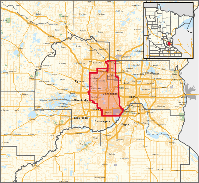
English: The congressional district in effect from 2023 to 2033, overlayed with other congressional districts and county boundaries, as well as primary & secondary roads, and water areas in Minnesota, with the Twin Cities area of Minneapolis–Saint Paul shown. Shapefiles from the United States Census Bureau, converted with Mapshaper (Mercator projection). |
| Date | |
| Source | Own work |
| Author | Twotwofourtysix |
Licensing[edit]
.svg&action=edit§ion=2)
I, the copyright holder of this work, hereby publish it under the following license:
This file is licensed under the Creative Commons Attribution 4.0 International license.
- You are free:
- to share – to copy, distribute and transmit the work
- to remix – to adapt the work
- Under the following conditions:
- attribution – You must give appropriate credit, provide a link to the license, and indicate if changes were made. You may do so in any reasonable manner, but not in any way that suggests the licensor endorses you or your use.
File history
Click on a date/time to view the file as it appeared at that time.
| Date/Time | Thumbnail | Dimensions | User | Comment | |
|---|---|---|---|---|---|
| current | 00:44, 28 January 2023 | | 800 × 735 (11.17 MB) | Twotwofourtysix (talk | contribs) | Adds inset |
| 16:30, 27 January 2023 |  | 800 × 735 (8.46 MB) | Twotwofourtysix (talk | contribs) | Uploaded own work with UploadWizard |
You cannot overwrite this file.
File usage on Commons
The following 2 pages use this file:
File usage on other wikis
The following other wikis use this file:
- Usage on en.wikipedia.org
- Usage on es.wikipedia.org
- Usage on fr.wikipedia.org
- Usage on it.wikipedia.org
- Usage on ko.wikipedia.org
- Usage on www.wikidata.org
- Usage on zh.wikipedia.org
.svg&oldid=821200296)