File:Missionary Ridge.png
Jump to navigation
Jump to search

Size of this preview: 351 × 599 pixels. Other resolutions: 140 × 240 pixels | 281 × 480 pixels | 450 × 768 pixels | 600 × 1,024 pixels | 2,000 × 3,413 pixels.
Original file (2,000 × 3,413 pixels, file size: 1.16 MB, MIME type: image/png)
Captions
Captions
Add a one-line explanation of what this file represents
Summary
[edit]
| Description | |
| Date | |
| Source | Own work, derived from source http://www.posix.com/CWmaps/ (PD) |
| Author | Hal Jespersen |
Licensing
[edit]
This file is licensed under the Creative Commons Attribution 3.0 Unported license.
Attribution: Hal Jespersen, www.posix.com/CW
- You are free:
- to share – to copy, distribute and transmit the work
- to remix – to adapt the work
- Under the following conditions:
- attribution – You must give appropriate credit, provide a link to the license, and indicate if changes were made. You may do so in any reasonable manner, but not in any way that suggests the licensor endorses you or your use.
Original upload log
[edit]
The original description page was here. All following user names refer to en.wikipedia.
- 2009-11-19 17:01 Hlj 1965×3398× (1018830 bytes) Updated Osterhaus's movement, based on 1896 War Dept map, available at http://historicalcharts.noaa.gov/historicals/historical_zoom.asp (map CWCK8 in the Tennessee series of CW maps). Same license.
- 2009-02-13 00:40 Hlj 1965×3398× (1014870 bytes) Corrected some unit movements. Same license. {{cc-by-3.0|Map by Hal Jespersen, www.posix.com/CW}}
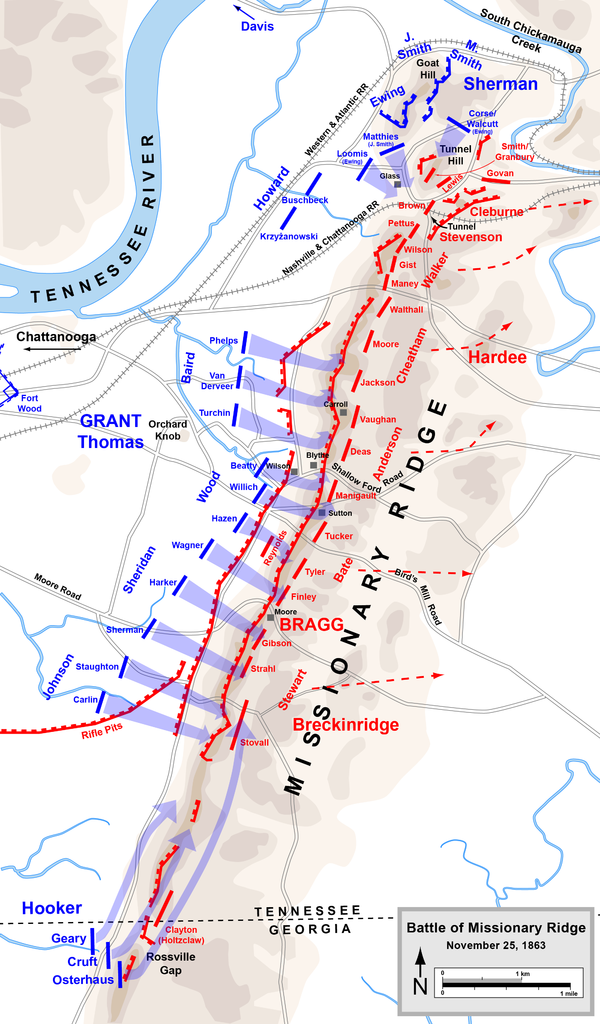
- 2009-01-31 23:03 Hlj 1965×3398× (995340 bytes) {{Information |Description=Map of [[Battle of Missionary Ridge]] of the [[American Civil War]]. Drawn in Adobe Illustrator CS3 by Hal Jespersen. Graphic source file is available at http://www.posix.com/CWmaps/ |Source=own work |Date= January 31, 2009 |Aut
File history
Click on a date/time to view the file as it appeared at that time.
| Date/Time | Thumbnail | Dimensions | User | Comment | |
|---|---|---|---|---|---|
| current | 23:31, 30 March 2011 | | 2,000 × 3,413 (1.16 MB) | Hlj (talk | contribs) | Updated graphical format of rivers and roads. Same license. |
| 15:23, 24 January 2010 |  | 1,965 × 3,398 (995 KB) | BotMultichill (talk | contribs) | {{BotMoveToCommons|en.wikipedia|year={{subst:CURRENTYEAR}}|month={{subst:CURRENTMONTHNAME}}|day={{subst:CURRENTDAY}}}} {{Information |Description={{en|Map of en:Battle of Missionary Ridge of the en:American Civil War. Drawn in Adobe Illustra |
You cannot overwrite this file.
File usage on Commons
There are no pages that use this file.
File usage on other wikis
The following other wikis use this file:
- Usage on en.wikipedia.org
- Usage on fr.wikipedia.org
- Usage on hy.wikipedia.org
- Usage on nl.wikipedia.org
- Usage on ru.wikipedia.org