File:Mitch 1998 track.png
পরিভ্রমণে চলুন
অনুসন্ধানে চলুন

এই প্রাকদর্শনের আকার: ৮০০ × ৫০২ পিক্সেল। অন্যান্য আকারসমূহ: ৩২০ × ২০১ পিক্সেল | ৬৪০ × ৪০১ পিক্সেল | ১,০২৪ × ৬৪২ পিক্সেল | ১,২৮০ × ৮০৩ পিক্সেল | ২,৭০০ × ১,৬৯৩ পিক্সেল।
মূল ফাইল (২,৭০০ × ১,৬৯৩ পিক্সেল, ফাইলের আকার: ২.৬৯ মেগাবাইট, এমআইএমই ধরন: image/png)
ক্যাপশনসমূহ
ক্যাপশন
এই ফাইল কি প্রতিনিধিত্ব করছে তার এক লাইন ব্যাখ্যা যোগ করুন
সারাংশ
| বিবরণ |
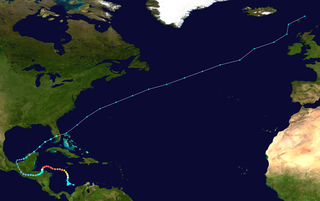
English: Track map of Hurricane Mitch of the 1998 Atlantic hurricane season. The points show the location of the storm at 6-hour intervals. The colour represents the storm's maximum sustained wind speeds as classified in the (see below), and the shape of the data points represent the nature of the storm, according to the legend below. Tropical depression (≤38 mph, ≤62 km/h)
Tropical storm (39–73 mph, 63–118 km/h)
Category 1 (74–95 mph, 119–153 km/h)
Category 2 (96–110 mph, 154–177 km/h)
Category 3 (111–129 mph, 178–208 km/h)
Category 4 (130–156 mph, 209–251 km/h)
Category 5 (≥157 mph, ≥252 km/h)
Unknown
Storm type |
||
| তারিখ | 1998-10-22–1998-11-09 | ||
| উৎস | Created by Supportstorm using Wikipedia:WikiProject Tropical cyclones/Tracks. The background image is from NASA. Tracking data is from the National Hurricane Center[1]. | ||
| লেখক | Supportstorm | ||
| Source code | Track map data table, if present below, is in HURDAT2 or ATCF format. See format details in [2] and [3], respectively.
|
লাইসেন্স প্রদান[সম্পাদনা]
| এই কাজের প্রণেতা Supportstorm কাজটি পাবলিক ডোমেইনে প্রকাশ করেছেন। এটি বিশ্বব্যাপী প্রযোজ্য হবে। কিছু দেশে এটি আইনত সিদ্ধ নাও হতে পারে, যদি তাই হয়: Supportstorm যে-কাউকে যেকোনো উদ্দেশ্যে, বিনাশর্তে এই কাজটি ব্যবহারের অনুমতি প্রদান করেন, যদি না সেই শর্তগুলো আইনত প্রয়োজনীয় হয়। |
ফাইলের ইতিহাস
যেকোনো তারিখ/সময়ে ক্লিক করে দেখুন ফাইলটি তখন কী অবস্থায় ছিল।
| তারিখ/সময় | সংক্ষেপচিত্র | মাত্রা | ব্যবহারকারী | মন্তব্য | |
|---|---|---|---|---|---|
| বর্তমান | ২২:৪৬, ১৮ জানুয়ারি ২০২০ | | ২,৭০০ × ১,৬৯৩ (২.৬৯ মেগাবাইট) | Supportstorm (আলোচনা | অবদান) | 2700 px |
| ২২:০৬, ১৬ সেপ্টেম্বর ২০১৮ |  | ১,০২৪ × ৬৪২ (৫৩০ কিলোবাইট) | LightandDark2000 (আলোচনা | অবদান) | Nothing wrong with the full track; it is also useful for seeing where the storm ended up. | |
| ২০:২৬, ৬ সেপ্টেম্বর ২০১৮ |  | ১,০২৪ × ৬৩৩ (৫২৭ কিলোবাইট) | MarioProtIV (আলোচনা | অবদান) | Reverted to version as of 04:49, 2 March 2012 (UTC) its hard to see the entire tropical portion if the ET takes up more space | |
| ১২:৩০, ১৫ সেপ্টেম্বর ২০১৪ |  | ১,০২৪ × ৬৪২ (৫৩০ কিলোবাইট) | Yaviky (আলোচনা | অবদান) | Reverted to version as of 02:29, 24 November 2009 : I prefer the full track because someone may want to know where was Mitch going outside the photo. See Hagibis 2014 track.png | |
| ০৪:৪৯, ২ মার্চ ২০১২ |  | ১,০২৪ × ৬৩৩ (৫২৭ কিলোবাইট) | Cyclonebiskit (আলোচনা | অবদান) | Reverted to version as of 13:29, 13 July 2006 focus on the tropical portion is more useful | |
| ০২:২৯, ২৪ নভেম্বর ২০০৯ |  | ১,০২৪ × ৬৪২ (৫৩০ কিলোবাইট) | Cyclonebiskit (আলোচনা | অবদান) | full track | |
| ১৩:২৯, ১৩ জুলাই ২০০৬ |  | ১,০২৪ × ৬৩৩ (৫২৭ কিলোবাইট) | Nilfanion (আলোচনা | অবদান) | ||
| ১৮:৩৬, ৪ ফেব্রুয়ারি ২০০৬ |  | ১,০২৪ × ৬৩৩ (৫২৬ কিলোবাইট) | Jdorje~commonswiki (আলোচনা | অবদান) | {{Hurricane auto track map|Hurricane Mitch (1998)}} | |
| ০১:২১, ১২ নভেম্বর ২০০৫ |  | ১,০২৪ × ৬৩৩ (৫২৭ কিলোবাইট) | Jdorje~commonswiki (আলোচনা | অবদান) | {{Hurricane auto track map|Hurricane Mitch (1998)}} |
আপনি এই ফাইলটি প্রতিস্থাপন করতে পারবেন না।
ফাইলের ব্যবহার
নিম্নলিখিত পাতাটি এই ফাইল ব্যবহার করে:
ফাইলের বৈশ্বিক ব্যবহার
নিচের অন্যান্য উইকিগুলো এই ফাইলটি ব্যবহার করে:
- ar.wikipedia.org-এ ব্যবহার
- bh.wikipedia.org-এ ব্যবহার
- bn.wikipedia.org-এ ব্যবহার
- ca.wikipedia.org-এ ব্যবহার
- cs.wikipedia.org-এ ব্যবহার
- de.wikipedia.org-এ ব্যবহার
- en.wikipedia.org-এ ব্যবহার
- es.wikipedia.org-এ ব্যবহার
- fi.wikipedia.org-এ ব্যবহার
- fr.wikipedia.org-এ ব্যবহার
- he.wikipedia.org-এ ব্যবহার
- hi.wikipedia.org-এ ব্যবহার
- hu.wikipedia.org-এ ব্যবহার
- it.wikipedia.org-এ ব্যবহার
- km.wikipedia.org-এ ব্যবহার
- ko.wikipedia.org-এ ব্যবহার
- lt.wikipedia.org-এ ব্যবহার
- nl.wikipedia.org-এ ব্যবহার
- or.wikipedia.org-এ ব্যবহার
- pl.wikipedia.org-এ ব্যবহার
- pt.wikipedia.org-এ ব্যবহার
- ro.wikipedia.org-এ ব্যবহার
- simple.wikipedia.org-এ ব্যবহার
- th.wikipedia.org-এ ব্যবহার
- vi.wikipedia.org-এ ব্যবহার
- zh.wikipedia.org-এ ব্যবহার