File:Mitch 1998 track.png
Zur Navigation springen
Zur Suche springen

Größe dieser Vorschau: 800 × 502 Pixel. Weitere Auflösungen: 320 × 201 Pixel | 640 × 401 Pixel | 1.024 × 642 Pixel | 1.280 × 803 Pixel | 2.700 × 1.693 Pixel.
Originaldatei (2.700 × 1.693 Pixel, Dateigröße: 2,69 MB, MIME-Typ: image/png)
Bildtexte
Kurzbeschreibungen
Ergänze eine einzeilige Erklärung, was diese Datei darstellt.
Beschreibung
| Beschreibung |
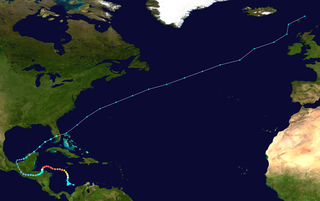
English: Track map of Hurricane Mitch of the 1998 Atlantic hurricane season. The points show the location of the storm at 6-hour intervals. The colour represents the storm's maximum sustained wind speeds as classified in the (see below), and the shape of the data points represent the nature of the storm, according to the legend below. Tropical depression (≤38 mph, ≤62 km/h)
Tropical storm (39–73 mph, 63–118 km/h)
Category 1 (74–95 mph, 119–153 km/h)
Category 2 (96–110 mph, 154–177 km/h)
Category 3 (111–129 mph, 178–208 km/h)
Category 4 (130–156 mph, 209–251 km/h)
Category 5 (≥157 mph, ≥252 km/h)
Unknown
Storm type |
||
| Datum | 1998-10-22–1998-11-09 | ||
| Quelle | Created by Supportstorm using Wikipedia:WikiProject Tropical cyclones/Tracks. The background image is from NASA. Tracking data is from the National Hurricane Center[1]. | ||
| Urheber | Supportstorm | ||
| Source code | Track map data table, if present below, is in HURDAT2 or ATCF format. See format details in [2] and [3], respectively.
|
Lizenz
[Bearbeiten]| Dieses Werk wurde von seinem Urheber Supportstorm als gemeinfrei veröffentlicht. Dies gilt weltweit. In manchen Staaten könnte dies rechtlich nicht möglich sein. Sofern dies der Fall ist: Supportstorm gewährt jedem das bedingungslose Recht, dieses Werk für jedweden Zweck zu nutzen, es sei denn, Bedingungen sind gesetzlich erforderlich. |
Dateiversionen
Klicke auf einen Zeitpunkt, um diese Version zu laden.
| Version vom | Vorschaubild | Maße | Benutzer | Kommentar | |
|---|---|---|---|---|---|
| aktuell | 22:46, 18. Jan. 2020 | | 2.700 × 1.693 (2,69 MB) | Supportstorm (Diskussion | Beiträge) | 2700 px |
| 22:06, 16. Sep. 2018 |  | 1.024 × 642 (530 KB) | LightandDark2000 (Diskussion | Beiträge) | Nothing wrong with the full track; it is also useful for seeing where the storm ended up. | |
| 20:26, 6. Sep. 2018 |  | 1.024 × 633 (527 KB) | MarioProtIV (Diskussion | Beiträge) | Reverted to version as of 04:49, 2 March 2012 (UTC) its hard to see the entire tropical portion if the ET takes up more space | |
| 12:30, 15. Sep. 2014 |  | 1.024 × 642 (530 KB) | Yaviky (Diskussion | Beiträge) | Reverted to version as of 02:29, 24 November 2009 : I prefer the full track because someone may want to know where was Mitch going outside the photo. See Hagibis 2014 track.png | |
| 04:49, 2. Mär. 2012 |  | 1.024 × 633 (527 KB) | Cyclonebiskit (Diskussion | Beiträge) | Reverted to version as of 13:29, 13 July 2006 focus on the tropical portion is more useful | |
| 02:29, 24. Nov. 2009 |  | 1.024 × 642 (530 KB) | Cyclonebiskit (Diskussion | Beiträge) | full track | |
| 13:29, 13. Jul. 2006 |  | 1.024 × 633 (527 KB) | Nilfanion (Diskussion | Beiträge) | ||
| 18:36, 4. Feb. 2006 |  | 1.024 × 633 (526 KB) | Jdorje~commonswiki (Diskussion | Beiträge) | {{Hurricane auto track map|Hurricane Mitch (1998)}} | |
| 01:21, 12. Nov. 2005 |  | 1.024 × 633 (527 KB) | Jdorje~commonswiki (Diskussion | Beiträge) | {{Hurricane auto track map|Hurricane Mitch (1998)}} |
Du kannst diese Datei nicht überschreiben.
Dateiverwendung
Die folgende Seite verwendet diese Datei:
Globale Dateiverwendung
Die nachfolgenden anderen Wikis verwenden diese Datei:
- Verwendung auf ar.wikipedia.org
- Verwendung auf bh.wikipedia.org
- Verwendung auf bn.wikipedia.org
- Verwendung auf ca.wikipedia.org
- Verwendung auf cs.wikipedia.org
- Verwendung auf de.wikipedia.org
- Verwendung auf en.wikipedia.org
- Verwendung auf es.wikipedia.org
- Verwendung auf fi.wikipedia.org
- Verwendung auf fr.wikipedia.org
- Verwendung auf he.wikipedia.org
- Verwendung auf hi.wikipedia.org
- Verwendung auf hu.wikipedia.org
- Verwendung auf it.wikipedia.org
- Verwendung auf km.wikipedia.org
- Verwendung auf ko.wikipedia.org
- Verwendung auf lt.wikipedia.org
- Verwendung auf nl.wikipedia.org
- Verwendung auf or.wikipedia.org
- Verwendung auf pl.wikipedia.org
- Verwendung auf pt.wikipedia.org
- Verwendung auf ro.wikipedia.org
- Verwendung auf simple.wikipedia.org
- Verwendung auf th.wikipedia.org
- Verwendung auf vi.wikipedia.org
- Verwendung auf zh.wikipedia.org