File:Moll - The north part of Great Britain called Scotland.png
Archivo original (2144 × 1224 píxeles; tamaño de archivo: 3,6 MB; tipo MIME: image/png)
Leyendas
Resumen[editar]
DescripciónMoll - The north part of Great Britain called Scotland.png |
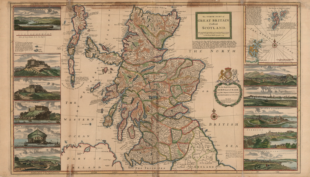
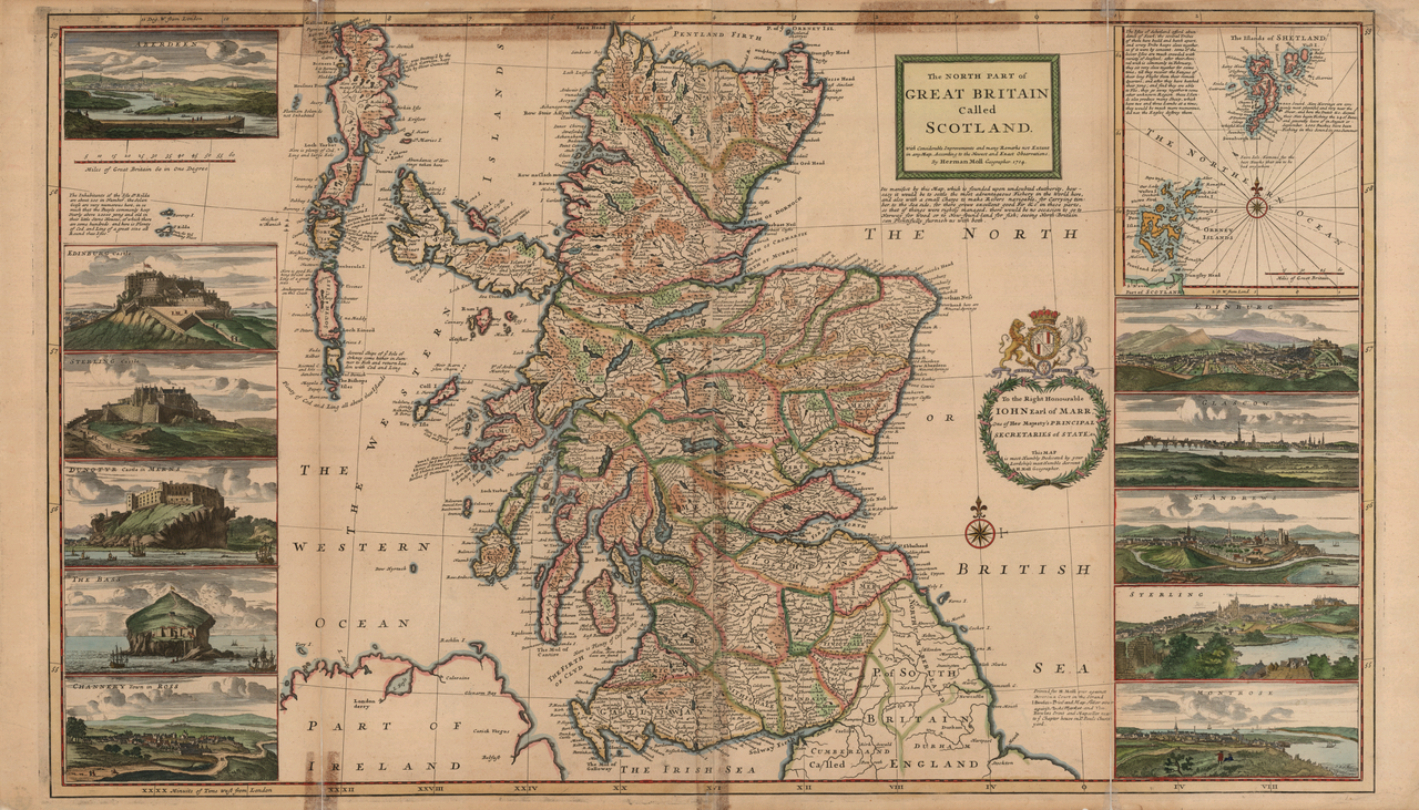
English: A c. 1714 map of Scotland with inset map of the Orkneys and Shetland Islands, many notes on the commercial fishing areas, and illustrations along the side taken from Jacobite broadsheets: Edinburgh, Edinburgh Castle, Stirling, Stirling Castle, Glasgow, Aberdeen, Montrose, Fortrose ("Channery"), St Andrews, Dunnottar Castle, and Bass Rock Castle.
|
|||||||||||||||||||||||
Fecha | reprint of a 1714 map | |||||||||||||||||||||||
Fuente | None provided or needed | |||||||||||||||||||||||
Autor |
creator QS:P170,Q1610319 |
|||||||||||||||||||||||
Otras versiones |
|
Licencia[editar]
Public domainPublic domainfalsefalse |
Este material está en dominio público en los demás países donde el derecho de autor se extiende por 100 años (o menos) tras la muerte del autor. También debes incluir una etiqueta de dominio público de los Estados Unidos para indicar por qué esta obra está en el dominio público en los Estados Unidos. | |
Esta obra ha sido identificada como libre de las restricciones conocidas en virtud del derecho de autor, incluyendo todos los derechos conexos. |
https://creativecommons.org/publicdomain/mark/1.0/PDMCreative Commons Public Domain Mark 1.0falsefalse
Annotations InfoField | This image is annotated: View the annotations at Commons |
ABERDEEN
THE BASS
EDINBURG Castle
STERLING Castle
DUNOTYR Castle
CHANNERY Town in ROSS
MONTROSE
STERLING
ST ANDREWS
GLASGOW
EDINBURG
Minuits of Time West from London
Printed for H. Moll over against
Devereux Court in the Strand
I. Bowles Print and Map Seller over
against Stocks Market and Tho.
Bowles Print and Map seller next
to yᵉ Chapter house in Sᵗ. Pauls Church
yard.
IOHN Earl of MARR,
One of Her Majesty's PRINCIPAL
SECRETARIES of STATE;
This MAP
is most Humbly Dedicated by your
Lordship's most Humble Servent
H. Moll Geographer.
UNIONE FORTIOR
The Inhabitants of the Isle Sᵗ Kilda
are about 200 in Number, the Selan
Geese are very numerous here, in so
much that the People commonly keep
Yearly above 20000 young and old in
their little Stone Houses, of which there
are some hundreds, and here is Plenty
of Cod, and Ling of a great size all
Round these Isles.
Deg. W. from London
Miles of Great Britain 60 in One Degree
Plenty of Code and Ling all about these Islands
Several Ships of yᵉ Isle of
Orkney come hither in Sum :
mmer to Fish and return Loa :
den with Cod and Ling.
Here is good Fis
hing for Cod and
Ling of a great size.
Here is Plenty of Cod and Ling.
Here is plenty of Cod,
Ling and large Kols
was Destroy'd by the
English Garrison, kept
there by Oliver Cromwell
Abundance of Her
rings taken here
GREAT BRITAIN
Called
SCOTLAND.
With Considerable Improvements and many Remarks not Extent
in any Map. According to the Newest and Exact Observations.
By Herman Moll Geographer. 1714.
It is manifest by this Map, which is founded upon undoubted Authority, how
easy it would be to settle the most advantageous Fishery in the World here,
and also with a small Charge to make Rivers navigable, for Carrying tim :
ber to the Sea side, for there grow excellent good Fir &c in these parts,
so that if things were rightly managed, there would be no occasion to go to
Norway for wood or to New-found-land for fish; seeing North Britain
can Plentifully furnish us with both.
The Isles of Schetland afford abun :
dence of Fowl, the several Tribes
of them here build and hatch apart,
and every Tribe keeps close together,
as if it were by consent; some of the
lesser Isles are much crowded with variety of Seafood; after their Arri :
val wich is commonly in February,
they sit very close together for some
time, till they recover the Fatigue of
their long Flight from their remote
Quarters, and after they have hatched
their Young; and find they are able
to Flie, they go away togeteher to some
other unknown Region, these Islan :
ds also produce many Sheep, which
have two and three Lambs at a time;
they would be much more numerous,
did not the Eagles destroy them.
Second, Here Herrigns are com :
monly most plentiful and very near the
Shoar, and here the Dutch &c. dispose
their Nets begin Fishing the 24 of Iune,
and generally leave of in August or
September, 2000 Bushes have been
Fishing in this Sound in one Summer.
Historial del archivo
Haz clic sobre una fecha y hora para ver el archivo tal como apareció en ese momento.
Fecha y hora | Miniatura | Dimensiones | Usuario | Comentario | |
---|---|---|---|---|---|
actual | 10:50 16 sep 2005 | 2144 × 1224 (3,6 MB) | Frank Schulenburg (discusión | contribs.) | Herman Moll: ''The north part of Great Britain called Scotland: with considerable inprovements and many remarks not extant in any map'', c.1726 (originally published 1714) {{Creator:Herman Moll}} Category:18th century maps |
No puedes sobrescribir este archivo.
Usos del archivo
Las siguientes páginas usan este archivo:
- Atlas of Scotland
- Herman Moll
- File:Glasgow - 'The Prospect of ye Town of Glasgow from ye South' (5372742532).jpg
- File:Jacobite broadside - Channery Town in Ross.jpg
- File:Jacobite broadside - Dunotyr Castle in Merns.jpg
- File:Jacobite broadside - St. Andrews.jpg
- File:Jacobite broadside - Stirling 03.jpg
- File:Jacobite broadside - Stirling Castle 02.jpg
Uso global del archivo
Las wikis siguientes utilizan este archivo:
- Uso en en.wikipedia.org
- Uso en es.wikipedia.org
- Uso en it.wikipedia.org
- Uso en pt.wikipedia.org
Datos estructurados
Elementos representados en este archivo
representa a
- 1726 maps
- Maps of Scotland by Herman Moll
- 1714 maps
- Coats of arms on maps
- John Erskine, 22nd Earl of Mar
- Maps with figures
- Edinburgh in the 18th century
- Glasgow in the 18th century
- St Andrews in the 18th century
- Stirling (city) in the 18th century
- Montrose in the 18th century
- Aberdeen in the 18th century
- Edinburgh Castle in art
- Stirling Castle in art
- Dunnottar Castle
- Bass Rock Castle
- Fortrose in the 18th century