File:Moscow, Volkhonka Street 18 (11-03-2016-001).jpg
Jump to navigation
Jump to search

Size of this preview: 800 × 600 pixels. Other resolutions: 320 × 240 pixels | 640 × 480 pixels | 1,024 × 768 pixels | 1,280 × 960 pixels | 2,560 × 1,920 pixels | 5,184 × 3,888 pixels.
Original file (5,184 × 3,888 pixels, file size: 7.06 MB, MIME type: image/jpeg)
Captions
Captions
Add a one-line explanation of what this file represents
Summary
[edit].jpg&action=edit§ion=1)
| Description |
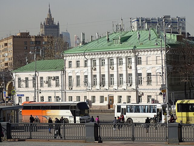
English: Moscow, capital of Russia. The building facing the Cathedral of Christ the Savior (Volkhonka Street 18 - Gogolevsky Boulevard 2) was built in 1772 for Alexey Yakovlev, and later belonged to Lodyzhensky and Stolypin families. Completely burned down in 1812, later restored. In 1831 the building was nationalized and became an elite school; eventually it was taken over by the Academy of Sciences. Presently it houses the Institute of Russian Language. Русский: Москва, Волхонка 18 / Гоголевский бульвар - бывшая усадьба Лодыженских и Столыпиных. Построена в 1772, выгорела в 1812, многократно перестраивалась. В 1831 году национализирована под размещение Первой гимназии, в XX веке перешла в управление Академии наук - здесь размещается Институт русского языка (http://www.ruslang.ru/). |
| Date | |
| Source | https://www.flickr.com/photos/pradig/25618970242/in/photolist-F2RViu-EfM5ZW-FdpEge-F2Ju5C-Eg4q4K-F55UGk-EKRteQ-EfHWXE-EfQBhd-EKYpa3-Egay7M-Eg3prV-FbhqD1-EKRVUJ-EKXZKN-EKXVob-EfKnJw-EKSQaA-FdqxhT-FdyjQT-EfGuHN-F534QB-EfK7RW-FdqpHV-Fbfkj7-F2HYw9-EfHb8E-Egb2KH-Eg7v12-EgbLXz-F2TUyQ-F2U4Zy-Fis7NW-F7M4th-FgauhN-Fitbze-FgNc8i-Fny9eD-FkJuVg-EfgQfU-EdHv59-DLzwzW-FbtWPi-EfHmsC-EKVT9L-Eg8qQM-EfRhNY-F51JEK-FbapeS-F2S3m7 |
| Author | Peter Radig |
| Camera location | | View this and other nearby images on: OpenStreetMap |
|---|
.jpg¶ms=055.744966_N_0037.604968_E_globe:Earth_type:camera__&language=en)
Licensing
[edit].jpg&action=edit§ion=2)
| This image was originally posted to Flickr by pradig at https://flickr.com/photos/99403088@N00/25618970242. It was reviewed on 25 March 2016 by FlickreviewR and was confirmed to be licensed under the terms of the cc-by-2.0. |
This file is licensed under the Creative Commons Attribution 2.0 Generic license.
- You are free:
- to share – to copy, distribute and transmit the work
- to remix – to adapt the work
- Under the following conditions:
- attribution – You must give appropriate credit, provide a link to the license, and indicate if changes were made. You may do so in any reasonable manner, but not in any way that suggests the licensor endorses you or your use.
File history
Click on a date/time to view the file as it appeared at that time.
| Date/Time | Thumbnail | Dimensions | User | Comment | |
|---|---|---|---|---|---|
| current | 10:17, 25 March 2016 | | 5,184 × 3,888 (7.06 MB) | Rakoon (talk | contribs) | User created page with UploadWizard |
You cannot overwrite this file.
File usage on Commons
The following 2 pages use this file:
File usage on other wikis
The following other wikis use this file:
- Usage on ru.wikivoyage.org
.jpg&oldid=644609747)