File:Mount Everest Climbing Routes 1924-1996 photomap-fr.svg
跳至導覽
跳至搜尋

此 SVG 檔案的 PNG 預覽的大小:800 × 596 像素。 其他解析度:320 × 238 像素 | 640 × 477 像素 | 1,024 × 763 像素 | 1,280 × 954 像素 | 2,560 × 1,907 像素 | 1,208 × 900 像素。
原始檔案 (SVG 檔案,表面大小:1,208 × 900 像素,檔案大小:1.11 MB)
說明
說明
添加單行說明來描述出檔案所代表的內容
摘要
[編輯]| 描述 |
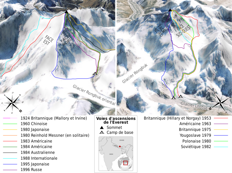
English: Map of the climbing routes opened on mount Everest by different expeditions between 1924 and 1996. Left view shows mount Everest at 215°, right view at 110°. French version. Français : Carte des voies d'ascensions ouvertes sur l'Everest par différentes expéditions entre 1924 et 1996. La vue de gauche montre l'Everest en direction du 215°, celle de droite du 110°. |
||
| 日期 | |||
| 來源 |
Own work. Sources :
|
||
| 作者 | Sémhur | ||
| 其他版本 | |||
| 姓名標示 (由许可协议要求) | © Sémhur / Wikimedia Commons / | ||
| SVG | W3C-validity not checked. 本vector image使用Inkscape創作 .
|
||
| Graphic Lab |

.svg)
| 目標地點 | | 位於此地的本圖片與其他圖片: OpenStreetMap |
|---|
授權條款
[編輯]
我,本作品的著作權持有者,決定用以下授權條款發佈本作品:
| 公共版權:本藝術作品是自由的,您可以依據自由藝術作品許可協議的條款傳播和/或修改本藝術作品。您可以在Copyleft Attitude網站或其他網站找到該許可協議的樣本。 |
您可以選擇您需要的授權條款。
檔案歷史
點選日期/時間以檢視該時間的檔案版本。
| 日期/時間 | 縮圖 | 尺寸 | 使用者 | 備註 | |
|---|---|---|---|---|---|
| 目前 | 2009年6月16日 (二) 11:45 | | 1,208 × 900(1.11 MB) | Sémhur(留言 | 貢獻) | =={{int:summary}}== {{Information |Description= {{en|Map of the climbing routes opened on mount Everest by different expeditions between 1924 and 1996. Left view shows mount Everest at 215°, right view at 110°. French version.}} {{ |
無法覆蓋此檔案。
檔案用途
沒有使用此檔案的頁面。
全域檔案使用狀況
以下其他 wiki 使用了這個檔案:
- bs.wikipedia.org 的使用狀況
- en.wikipedia.org 的使用狀況
- fr.wikipedia.org 的使用狀況
- sh.wikipedia.org 的使用狀況
- sr.wikipedia.org 的使用狀況
- zh.wikipedia.org 的使用狀況