File:Moyen Orient Amarna 1.svg

原本檔案 (SVG檔案,表面大細: 1,885 × 1,354 像素,檔案大細:4.02 MB)
Captions
Captions

|
This SVG file contains embedded text that can be translated into your language, using any capable SVG editor, text editor or the SVG Translate tool. For more information see: About translating SVG files. |
| 描述 |
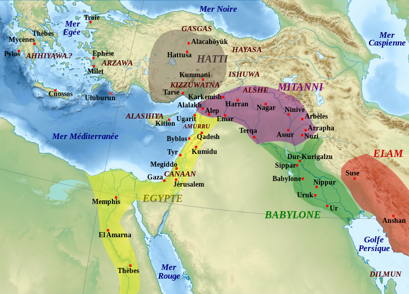
English: Map of the Middle East in the beginning of the Amarna letters period, the first half of the 14th century BC. The extension of the dominions of the great kingdoms is approximate. Remarks : the extension of the Arzawa is not shown because of its uncertainty, it may have covered the main part of Western Anatolia ; the Ahhiyawa are here supposed to be the "Mycaneans" ; the extension of Elam is very approximate. Español: Mapa de l'Orient Mitjà al començament del període de les cartes d'Amarna, la primera meitat del segle XIV aC. L'extensió dels dominis dels grans regnes és aproximada. Observacions: l'extensió de l'Arzawa no es mostra a causa de la seva incertesa, podria haver cobert la part principal de l'Anatòlia occidental ; els Ahhiyawa aquí se suposa que són els "micènics"; l'extensió d'Elam és molt aproximada. Français : Carte de la situation politique du Moyen-Orient au début de la période des Lettres d'Amarna, première moitié du XIVe siècle av. J.-C. L'extension des zones dominées par les grands royaumes est approximative. Remarques : l'extension de l'Arzawa n'est pas notée car trop incertaine, mais doit couvrir la majeure partie de l'Anatolie occidentale ; les Ahhiyawa sont considérés comme correspondant à la civilisation mycénienne ; l'extension de l'Elam est approximative. |
| 日期 | (UTC) |
| 來源 | |
| 作者 |
|
| Other versions |
File:Moyen Orient Amarna 1.svg has 2 translations.
Other related versions: []
|


|
|
This SVG file contains embedded text that can be translated into your language, using any capable SVG editor, text editor or the SVG Translate tool. For more information see: About translating SVG files. |
This file is translated using SVG <switch> elements. All translations are stored in the same file! Learn more.
For most Wikipedia projects, you can embed the file normally (without a To translate the text into your language, you can use the SVG Translate tool. Alternatively, you can download the file to your computer, add your translations using whatever software you're familiar with, and re-upload it with the same name. You will find help in Graphics Lab if you're not sure how to do this. |
| This is a retouched picture, which means that it has been digitally altered from its original version. Modifications: Ajout des royaumes, sites archéologiques et régions.. The original can be viewed here: Middle East topographic map-blank.svg:
|
- 你可以:
- 去分享 – 複製、發佈同傳播呢個作品
- 再改 – 創作演繹作品
- 要遵照下面嘅條件:
- 署名 – 你一定要畀合適嘅表彰、畀返指向呢個授權條款嘅連結,同埋寫明有無改過嚟。你可以用任何合理方式去做,但唔可以用任何方式暗示授權人認可咗你或者你嘅使用方式。
- 相同方式分享 – 如果你用任何方式改過呢個作品,你必須要用返原本或者相似嘅條款發佈。

|
根據自由軟體基金會發佈嘅無固定段落、封面文字同封底文字GNU自由文件授權條款第1.2或打後嘅版本,你獲授權可以重製、散佈同埋修改爾份文件。授權條款嘅副本喺章節GNU自由文件授權條款。 |
Original upload log[編輯]
This image is a derivative work of the following images:
- File:Middle_East_topographic_map-blank.svg licensed with Cc-by-sa-3.0,2.5,2.0,1.0, GFDL
- 2010-11-03T17:52:56Z Sémhur 3097x1938 (10510751 Bytes) == {{int:filedesc}} == {{Information |Description={{Multilingual description |en= Blank physical map of the [[:en:Middle East|Middle East]] |fr= Carte physique vierge du [[:fr:Moyen-Orient|Moyen-Orient]]. }} |Source={{own}}.
Uploaded with derivativeFX
檔案歷史
撳個日期/時間去睇響嗰個時間出現過嘅檔案。
| 日期/時間 | 縮圖 | 尺寸 | 用戶 | 註解 | |
|---|---|---|---|---|---|
| 現時 | 2024年2月22號 (四) 18:58 | | 1,885 × 1,354(4.02 MB) | Manlleus(傾偈 | 貢獻) | File uploaded using svgtranslate tool (https://svgtranslate.toolforge.org/). Added translation for ca. |
| 2024年2月22號 (四) 17:47 |  | 1,885 × 1,354(3.96 MB) | Manlleus(傾偈 | 貢獻) | fixed text labels for translation | |
| 2020年10月19號 (一) 12:47 |  | 1,885 × 1,354(3.97 MB) | Rebblumstein(傾偈 | 貢獻) | Reverted to version as of 14:58, 6 March 2016 (UTC) (Until I fix it more thoroughly) | |
| 2020年10月19號 (一) 12:02 |  | 1,885 × 1,354(3.97 MB) | Rebblumstein(傾偈 | 貢獻) | Removed more nested <tspan> elements | |
| 2020年10月19號 (一) 11:50 |  | 1,885 × 1,354(3.97 MB) | Rebblumstein(傾偈 | 貢獻) | Removed nested <tspan> elements | |
| 2016年3月6號 (日) 14:58 |  | 1,885 × 1,354(3.97 MB) | Geagea(傾偈 | 貢獻) | Reverted to version as of 20:28, 28 October 2011 (UTC) | |
| 2016年3月6號 (日) 14:57 |  | 1,885 × 1,354(3.97 MB) | Geagea(傾偈 | 貢獻) | Editing SVG source code using User:Rillke/SVGedit.js; upload handled by User:Rillke/MwJSBot.js | |
| 2011年10月28號 (五) 20:28 |  | 1,885 × 1,354(3.97 MB) | Zunkir(傾偈 | 貢獻) | Police et remaniements mineurs. | |
| 2010年11月14號 (日) 19:30 |  | 1,885 × 1,354(3.96 MB) | Zunkir(傾偈 | 貢獻) | {{Information |Description={{Multilingual description |fr= Carte de la situation politique du Moyen-Orient au début de la période des Lettres d'Amarna, première moitié du XIVe siècle av. J.-C. L'extension des zones dominées par les grands royaumes e |
你無得衾咗個檔案。
檔案用途
以下嘅8版用到呢個檔:
- User:Magog the Ogre/Multilingual legend/2024 February 20-24
- File:Moyen Orient Amarna 1-es.svg
- File:Moyen Orient Amarna 1-pt.svg
- File:Moyen Orient Amarna 1.he.svg
- File:Moyen Orient Amarna 1.png
- File:Moyen Orient Amarna 1.svg
- File:Moyen Orient Amarna 1 eu.svg
- Template:Other versions/Moyen Orient Amarna 1
全域檔案使用情況
下面嘅維基都用緊呢個檔案:
- ar.wikipedia.org嘅使用情況
- ca.wikipedia.org嘅使用情況
- de.wikipedia.org嘅使用情況
- en.wikipedia.org嘅使用情況
- es.wikipedia.org嘅使用情況
- fr.wikipedia.org嘅使用情況
- Pharaon
- Mésopotamie
- Hittites
- Kizzuwatna
- Hébreux
- Histoire de l'Irak
- Lettres d'Amarna
- Liste des souverains de Babylone
- Assur-uballit Ier
- Histoire de la Mésopotamie
- Proche-Orient ancien
- Diplomatie dans le Proche-Orient ancien
- Mittani
- Histoire des Hittites
- Utilisateur:Zunkir/POA autres
- Utilisateur:Soutekh67/Bac à sable (Egypte)
- Amurru (royaume)
- Utilisateur:Zunkir/cartothèque
睇呢個檔案嘅更多全域使用情況。