File:NESDIS Atlantic Ocean 1 June 0000-0600.png
Jump to navigation
Jump to search

Size of this preview: 450 × 600 pixels. Other resolutions: 180 × 240 pixels | 360 × 480 pixels | 720 × 960 pixels.
Original file (720 × 960 pixels, file size: 1.27 MB, MIME type: image/png)
Captions
Captions
Add a one-line explanation of what this file represents
Summary[edit]
| Description |
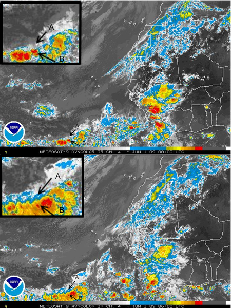
Deutsch: Infrarot-Satellitenaufnahmen des östlichen Atlantischen Ozeans desNOAA Satellite and Information Service von 0000 und von 0600 Weltzeit (UTC) am 1. Juni 2009. Die vergrößerten Bilder sind Ausschnitte der Karte mit Bezug zum Flug Air France AF 447 ("A" zeigt die letzte bekannte Position, "B" die tatsächliche Position des in der Nacht vom 31. Mai zum 1. Juni 2009 abgestürzten Airbus A330-203 [F-GZCP]), sh. de:Air-France-Flug 447
English: NOAA Satellite and Information Service satellite view of Eastern Atlantic Ocean, showing IR variation on 0000 and 0600 GMT (UTC) on 1 June 2009. Inset images detail area where AF 447 fell. A is the last known position of the aircraft, and B is where the debris were found. (The positions were marked using as reference the latitude/longitude lines optional in the original NOAA images)
Français : Vue satellite par le National Oceanic and Atmospheric Administration de l’est de l’océan Atlantique, montrant les variations IR entre 0000 and 0600 GMT (UTC) le 1er juin 2009. Les images insérées détaillent la zone où l’AF 447 est tombé. A est la dernière position connue de l’avion, et B est l’endroit où les débris ont été trouvés.
Português: Imagens de satélite feitas pela NOAA captadas às 00h e às 06h UTC do dia 1 de junho de 2009, revelando a alta concentração de nuvens perto do arquipélago de São Pedro e São Paulo, na Zona de Convergência Intertropical. "A" representa a última posição conhecida do avião, e "B" o local onde foram encontrados os destroços. (as posições foram marcadas utilizando como referência as linhas de latitude e longitude opcionais na imagem original). |
|||
| Date | ||||
| Source |
English: Extracted from National Environmental Satellite, Data and Information Service (NESDIS) animated loop at http://www.ssd.noaa.gov/eumet/eatl/loop-avn.html by User:DarwIn. |
|||
| Author | NOAA | |||
| Permission (Reusing this file) |
|
File history
Click on a date/time to view the file as it appeared at that time.
| Date/Time | Thumbnail | Dimensions | User | Comment | |
|---|---|---|---|---|---|
| current | 04:53, 3 June 2009 | | 720 × 960 (1.27 MB) | DarwIn (talk | contribs) | Point identification |
| 04:49, 3 June 2009 |  | 720 × 960 (1.27 MB) | DarwIn (talk | contribs) | {{Information |Description={{en|{{w|NOAA|NOAA Satellite and Information Service}} satellite view of Eastern Atlantic Ocean, showing IR variation on 0000 and 0600 GMT (UTC) on 1 June 2009.}} |Source=Extracted from National Environmental Satellite, Data and |
You cannot overwrite this file.
File usage on Commons
There are no pages that use this file.
File usage on other wikis
The following other wikis use this file:
- Usage on en.wikipedia.org
- Usage on es.wikipedia.org
- Usage on pt.wikipedia.org