File:NPS mesa-verde-wetherill-mesa-detail-map.jpg
Jump to navigation
Jump to search

Size of this preview: 572 × 600 pixels. Other resolutions: 229 × 240 pixels | 576 × 604 pixels.
Original file (576 × 604 pixels, file size: 67 KB, MIME type: image/jpeg)
Captions
Captions
Add a one-line explanation of what this file represents
Summary
[edit]
| Description |
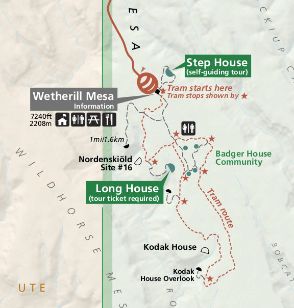
English: This Wetherill Mesa map, focusing on the tram route that serves the Long House, Badger House, and Kodak House. You’ll also find trails to other lookouts and ruins, such as the Step House. |
| Date | |
| Source | U.S. National Park Service (http://npmaps.com/wp-content/uploads/mesa-verde-wetherill-mesa-detail-map.jpg) |
| Author | U.S. National Park Service, restoration/cleanup by Matt Holly |
Licensing
[edit]
| This image or media file contains material based on a work of a National Park Service employee, created as part of that person's official duties. As a work of the U.S. federal government, such work is in the public domain in the United States. See the NPS website and NPS copyright policy for more information. |
File history
Click on a date/time to view the file as it appeared at that time.
| Date/Time | Thumbnail | Dimensions | User | Comment | |
|---|---|---|---|---|---|
| current | 01:02, 17 May 2017 | | 576 × 604 (67 KB) | RKBot (talk | contribs) | =={{int:filedesc}}== {{Information |description= {{en|1=This Wetherill Mesa map, focusing on the tram route that serves the Long House, Badger House, and Kodak House. You’ll also find trails to other lookouts and ruins, such as the Step House.}} |dat... |
You cannot overwrite this file.
File usage on Commons
The following page uses this file: