Category:Maps of Mesa Verde National Park
Jump to navigation
Jump to search
United States national parks: Acadia · American Samoa · Arches · Badlands · Big Bend · Biscayne · Black Canyon of the Gunnison · Bryce Canyon · Canyonlands · Capitol Reef · Carlsbad Caverns · Channel Islands · Congaree · Crater Lake · Cuyahoga Valley · Death Valley · Denali · Dry Tortugas · Everglades · Gateway Arch · Gates of the Arctic · Glacier · Glacier Bay · Grand Canyon · Grand Teton · Great Basin · Great Smoky Mountains · Guadalupe Mountains · Haleakalā · Hawaii Volcanoes · Hot Springs · Indiana Dunes · Isle Royale · Joshua Tree · Kenai Fjords · Kings Canyon · Kobuk Valley · Lake Clark · Lassen Volcanic · Mammoth Cave · Mesa Verde · Mount Rainier · North Cascades · Olympic · Petrified Forest · Pinnacles · Redwood · Rocky Mountain · Saguaro · Sequoia · Shenandoah · Theodore Roosevelt · Virgin Islands · Voyageurs · White Sands · Wind Cave · Wrangell-St. Elias · Yellowstone · Yosemite · Zion
English: Maps of Mesa Verde National Park
Wikimedia category | |||||
| Upload media | |||||
| Instance of | |||||
|---|---|---|---|---|---|
| Category combines topics | |||||
| Mesa Verde National Park | |||||
U.S. national park in Colorado   .jpg) | |||||
| Instance of | |||||
| Location | Montezuma County, Colorado | ||||
| Visitor center |
| ||||
| Operator | |||||
| Heritage designation |
| ||||
| IUCN protected areas category | |||||
| Inception |
| ||||
| Highest point | |||||
| Area |
| ||||
| Visitors per year |
| ||||
| official website | |||||
 | |||||
Subcategories
This category has the following 2 subcategories, out of 2 total.
Media in category "Maps of Mesa Verde National Park"
The following 20 files are in this category, out of 20 total.
-
 LocMap Mesa Verde.png 280 × 183; 17 KB
-
 Map of Mesa Verde - DPLA - 738b48276b568bf3d900f3a48957d533.jpg 4,479 × 5,000; 2.3 MB
-
 Map of Mesa Verde National Park.png 3,249 × 3,518; 3.35 MB
-
 Mesa verde map.png 1,204 × 1,674; 272 KB
-
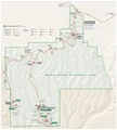
 Mesa Verde park map.png 4,989 × 5,473; 23.88 MB
-
 Mesa Verde road map.png 436 × 395; 5 KB
-
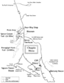
 NPS mesa-verde-chapin-mesa-detail-map.jpg 822 × 858; 133 KB
-
 NPS mesa-verde-chapin-mesa-map.gif 799 × 1,028; 109 KB
-
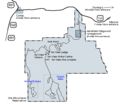
 NPS mesa-verde-entrance-area-map.jpg 828 × 692; 103 KB
-
 NPS mesa-verde-map.jpg 2,973 × 3,290; 1.13 MB
-
 NPS mesa-verde-map.pdf 2,477 × 2,741; 4.3 MB
-
 NPS mesa-verde-morefield-campground-map.jpg 1,200 × 925; 333 KB
-
 NPS mesa-verde-spruce-tree-house-detail-map.gif 463 × 1,052; 108 KB
-
 NPS mesa-verde-vegetation-map.jpg 1,868 × 2,397; 708 KB
-
 NPS mesa-verde-wetherill-mesa-detail-map.jpg 576 × 604; 67 KB
-
 NPS mesa-verde-wetherill-mesa-map.jpg 943 × 1,237; 146 KB
-
 NPS mesa-verde-wetherill-mesa-printable-map.gif 1,194 × 1,293; 87 KB
-
 Road map mesa verde.png 464 × 404; 20 KB
-
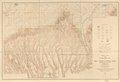
 Topographic map of Mesa Verde National Park - Montezuma County, Colorado LOC 2012586820.jpg 13,338 × 9,152; 19.48 MB
-
 Topographic map of Mesa Verde National Park - Montezuma County, Colorado LOC 2012586820.tif 13,338 × 9,152; 349.24 MB


