File:Naja nivea hooding while swimming 2 - Sonja van Zyl.jpg
Jump to navigation
Jump to search
Size of this preview: 800 × 561 pixels. Other resolutions: 320 × 225 pixels | 640 × 449 pixels | 1,024 × 719 pixels | 1,280 × 898 pixels | 2,048 × 1,437 pixels.
Original file (2,048 × 1,437 pixels, file size: 1.06 MB, MIME type: image/jpeg)
Captions
Captions
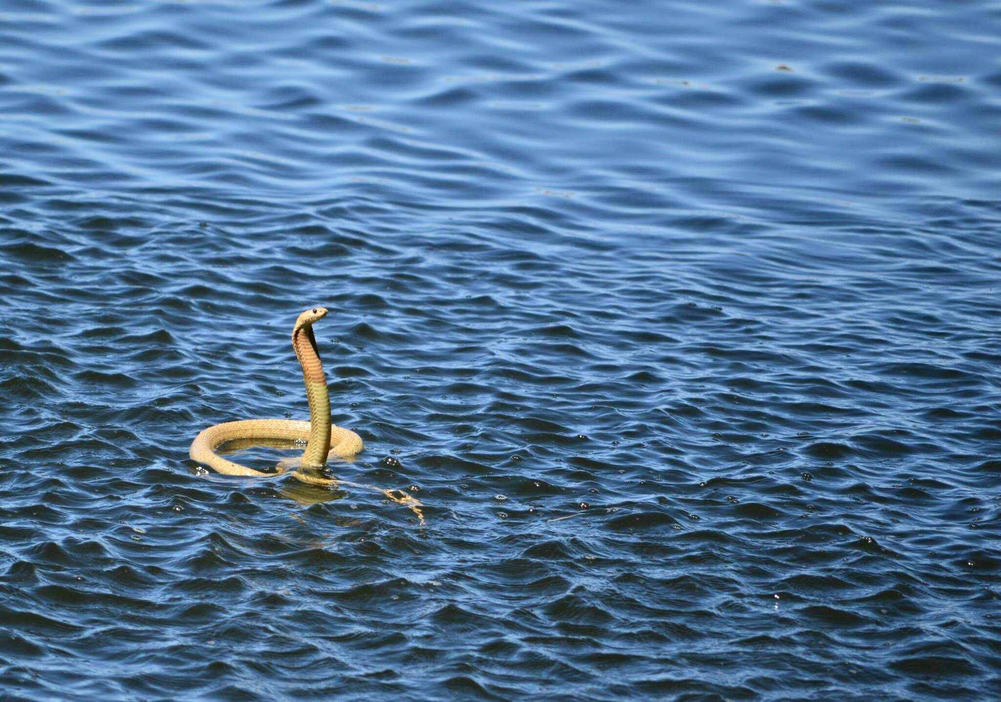
Naja nivea hooding while swimming
Summary[edit]
| Description |
Afrikaans: 'n Geelslang maak bakkop terwyl dit oor 'n Kaapse dam swem. Sodra dit deur die boot genader is het dit ophou swem, die kop volkome opgelig en bakkop gemaak. Al drywende het dit dus die terrestriële houding ingeneem.
Goedgunstig beskikbaar gestel deur Sonja van Zyl, nadat sy die foto's by Die Mond in die Karoo geneem het. Die Geelslang, Naja nivea, is in die dam sien swem terwyl hulle in 'n boot gevaar het. Die liggaam wat so hoog in die water drywe is aan die volkome opgeblase long toe te skryf, terwyl die effektief soliede stert laer in die water hang. Al is Geelslange nie akwaties nie, is hulle soos meeste slangspesies goeie swemmers. Hierdie een het effens bakkop gemaak toe dit die boot gewaar, en toe die boot nader kom het dit al drywende dieselfde verdedigende houding ingeneem as tydens 'n bedreiging op land. English: Naja nivea hooding while swimming across a dam. It began as soon as the boat approached, and then stopped swimming and reared fully, adopting the terrestrial behaviour pattern while still floating. Kindly made available by Sonja van Zyl, after she had taken the photographs at Die Mond in the Karoo. The Cape cobra, Naja nivea was seen swimming in the dam where they were boating. Its body floating so high in the water reflects how fully it had inflated its lung, though the effectively solid tail hangs lower in the water. Though Cape cobras are not aquatic, they swim effectively, like most active snake species. This one began hooding slightly when disturbed by the boat, and when the boat approached more closely, the snake reared, demonstrating the same attitude as that of the defensive threat on land, while still floating. |
| Date | |
| Source | Own work |
| Author | JonRichfield |
| Other versions |
 |
| Camera location | | View this and other nearby images on: OpenStreetMap |
|---|
Licensing[edit]
I, the copyright holder of this work, hereby publish it under the following license:
This file is licensed under the Creative Commons Attribution-Share Alike 4.0 International license.
- You are free:
- to share – to copy, distribute and transmit the work
- to remix – to adapt the work
- Under the following conditions:
- attribution – You must give appropriate credit, provide a link to the license, and indicate if changes were made. You may do so in any reasonable manner, but not in any way that suggests the licensor endorses you or your use.
- share alike – If you remix, transform, or build upon the material, you must distribute your contributions under the same or compatible license as the original.
File history
Click on a date/time to view the file as it appeared at that time.
| Date/Time | Thumbnail | Dimensions | User | Comment | |
|---|---|---|---|---|---|
| current | 06:05, 1 March 2017 | | 2,048 × 1,437 (1.06 MB) | JonRichfield (talk | contribs) | User created page with UploadWizard |
You cannot overwrite this file.
File usage on Commons
The following page uses this file:
File usage on other wikis
The following other wikis use this file:
- Usage on id.wikipedia.org