File:Nargis 2008 track.png
Pāriet uz navigāciju
Pāriet uz meklēšanu
Šī priekšskata izmērs: 800 × 495 pikseļi. Citi izmēri: 320 × 198 pikseļi | 640 × 396 pikseļi | 1 024 × 633 pikseļi | 1 280 × 791 pikseļi | 2 700 × 1 669 pikseļi.
Sākotnējais fails (2 700 × 1 669 pikseļi, faila izmērs: 4,64 MB, MIME tips: image/png)
Captions
Captions
Pievieno vienas rindiņas aprakstu, ko šis fails attēlo
Kopsavilkums
| Apraksts |
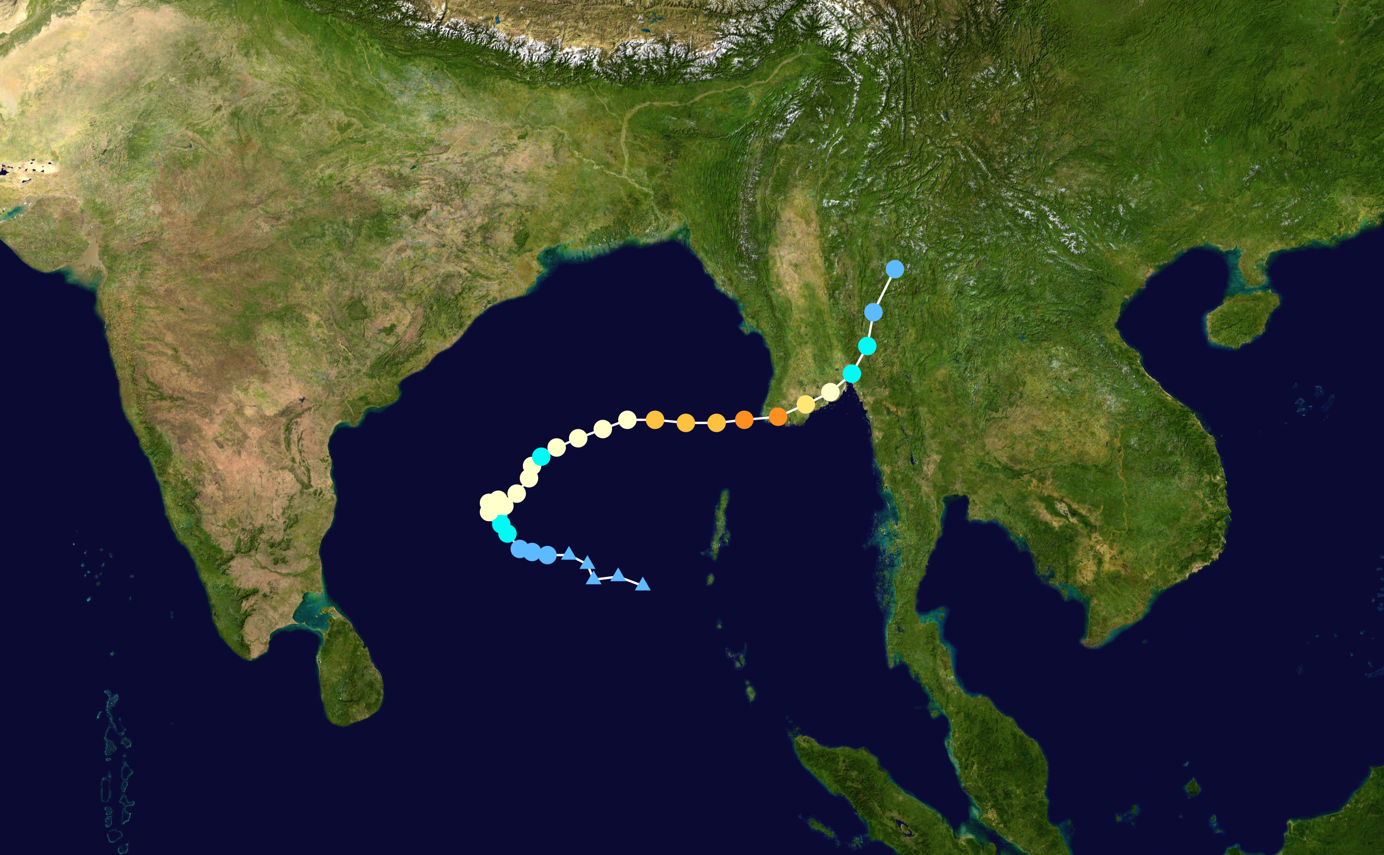
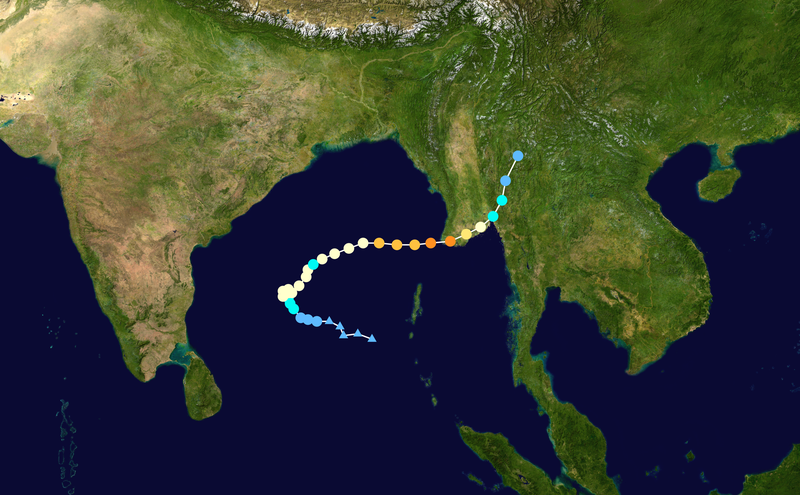
English: Track map of Extremely Severe Cyclonic Storm Nargis of the 2008 North Indian Ocean cyclone season. The points show the location of the storm at 6-hour intervals. The colour represents the storm's maximum sustained wind speeds as classified in the (see below), and the shape of the data points represent the nature of the storm, according to the legend below. Tropical depression (≤38 mph, ≤62 km/h)
Tropical storm (39–73 mph, 63–118 km/h)
Category 1 (74–95 mph, 119–153 km/h)
Category 2 (96–110 mph, 154–177 km/h)
Category 3 (111–129 mph, 178–208 km/h)
Category 4 (130–156 mph, 209–251 km/h)
Category 5 (≥157 mph, ≥252 km/h)
Unknown
Storm type |
||
| Datums | 2008-04-25–2008-05-04 | ||
| Avots | Created by Ramisses using Wikipedia:WikiProject Tropical cyclones/Tracks. The background image is from NASA. Tracking data is from the Joint Typhoon Warning Center[1]. | ||
| Autors | Ramisses | ||
| Source code | Track map data table, if present below, is in HURDAT2 or ATCF format. See format details in [2] and [3], respectively.
|
Licence
[labot šo sadaļu]| This work has been released into the public domain by its author, Ramisses. This applies worldwide. In some countries this may not be legally possible; if so: Ramisses grants anyone the right to use this work for any purpose, without any conditions, unless such conditions are required by law. |
Faila hronoloģija
Uzklikšķini uz datums/laiks kolonnā esošās saites, lai apskatītos, kā šis fails izskatījās tad.
| Datums/Laiks | Attēls | Izmēri | Dalībnieks | Komentārs | |
|---|---|---|---|---|---|
| tagadējais | 2020. gada 18. jūlijs, plkst. 03.13 | | 2 700 × 1 669 (4,64 MB) | Supportstorm (diskusija | devums) | 2700 px |
| 2013. gada 19. maijs, plkst. 15.12 |  | 2 000 × 1 236 (2,25 MB) | Cyclonebiskit (diskusija | devums) | higher resolution | |
| 2009. gada 31. marts, plkst. 19.17 |  | 1 024 × 633 (820 KB) | Potapych (diskusija | devums) | Best track update | |
| 2008. gada 30. maijs, plkst. 14.33 |  | 1 024 × 633 (770 KB) | Nilfanion (diskusija | devums) | Cleaner track (anti-aliasing) | |
| 2008. gada 29. maijs, plkst. 23.44 |  | 1 024 × 633 (766 KB) | Nilfanion (diskusija | devums) | WPTC track | |
| 2008. gada 7. maijs, plkst. 03.04 |  | 1 024 × 636 (24 KB) | Ramisses (diskusija | devums) | == Summary == Cyclone Jokwe track map. Tracking data from [https://metocph.nmci.navy.mil/jtwc.php JTWC] '''Alert''', This track map should be replaced by a WikiProject Tropical cyclones track map when is available. {{Information |Description=Cyclone Nar |
Šo failu nevar pārrakstīt.
Faila lietojums
Šo failu neizmanto nevienā lapā.
Globālais faila lietojums
Šīs Vikipēdijas izmanto šo failu:
- Izmantojums ar.wikipedia.org
- Izmantojums ca.wikipedia.org
- Izmantojums cs.wikipedia.org
- Izmantojums da.wikipedia.org
- Izmantojums de.wikipedia.org
- Izmantojums en.wikipedia.org
- Izmantojums fi.wikipedia.org
- Izmantojums fr.wikipedia.org
- Izmantojums he.wikipedia.org
- Izmantojums id.wikipedia.org
- Izmantojums ja.wikipedia.org
- Izmantojums ko.wikipedia.org
- Izmantojums lv.wikipedia.org
- Izmantojums ml.wikipedia.org
- Izmantojums my.wikipedia.org
- Izmantojums nl.wikipedia.org
- Izmantojums no.wikipedia.org
- Izmantojums pl.wikipedia.org
- Izmantojums pt.wikipedia.org
- Izmantojums ro.wikipedia.org
- Izmantojums sco.wikipedia.org
- Izmantojums sk.wikipedia.org
- Izmantojums sv.wikipedia.org
- Izmantojums th.wikipedia.org
- Izmantojums vi.wikipedia.org
- Izmantojums zh.wikipedia.org