File:National 113th Congressional District Wall Map.pdf
Jump to navigation
Jump to search

Size of this JPG preview of this PDF file: 800 × 593 pixels. Other resolutions: 320 × 237 pixels | 640 × 475 pixels | 1,024 × 759 pixels | 1,280 × 949 pixels | 2,560 × 1,898 pixels | 6,675 × 4,950 pixels.
Original file (6,675 × 4,950 pixels, file size: 16.68 MB, MIME type: application/pdf)
Captions
Captions
Add a one-line explanation of what this file represents
Summary[edit]
| Description |
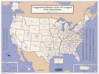
English: Census Bureau map of Congressional Districts in the 113th Congress including 50 states, DC and five territories |
| Date | |
| Source | https://www.census.gov/geo/maps-data/maps/cd113_us_wallmap.html |
| Author | U.S. Census Bureau |
Licensing[edit]
This image or file is a work of a United States Census Bureau employee, taken or made as part of that person's official duties. As a work of the U.S. federal government, the image is in the public domain.
|
 |
File history
Click on a date/time to view the file as it appeared at that time.
| Date/Time | Thumbnail | Dimensions | User | Comment | |
|---|---|---|---|---|---|
| current | 08:40, 21 August 2015 |  | 6,675 × 4,950 (16.68 MB) | TheVirginiaHistorian (talk | contribs) | User created page with UploadWizard |
You cannot overwrite this file.
File usage on Commons
There are no pages that use this file.
File usage on other wikis
The following other wikis use this file:
- Usage on en.wikipedia.org
- Usage on it.wikipedia.org
- Usage on simple.wikipedia.org
- Usage on zh.wikipedia.org