File:Naturraumkarte Thueringer Becken.png
Jump to navigation
Jump to search
Size of this preview: 794 × 600 pixels. Other resolutions: 318 × 240 pixels | 636 × 480 pixels | 1,017 × 768 pixels | 1,280 × 966 pixels | 1,935 × 1,461 pixels.
Original file (1,935 × 1,461 pixels, file size: 3.78 MB, MIME type: image/png)
Captions
Captions
Add a one-line explanation of what this file represents
Summary
[edit]
| Description |
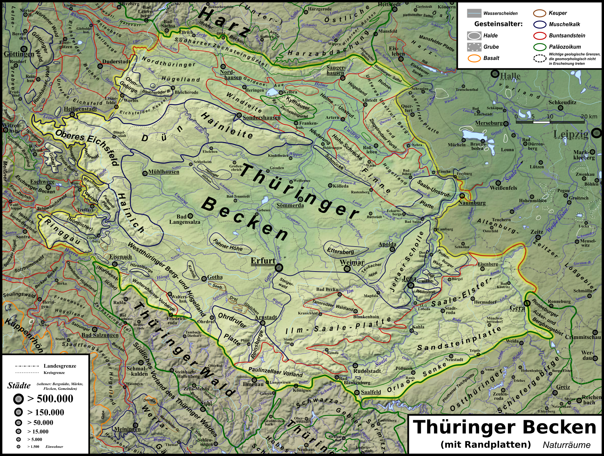
Deutsch: Naturraumkarte des Thüringer Beckens; hervorgehoben sind auch externe Muschelkalk-Zeugenberge. |
| Date | |
| Source | Own work |
| Author |
|
| Other versions | Siehe Galerie |
Licensing
[edit]
I, the copyright holder of this work, hereby publish it under the following license:
This file is licensed under the Creative Commons Attribution 3.0 Unported license.
- You are free:
- to share – to copy, distribute and transmit the work
- to remix – to adapt the work
- Under the following conditions:
- attribution – You must give appropriate credit, provide a link to the license, and indicate if changes were made. You may do so in any reasonable manner, but not in any way that suggests the licensor endorses you or your use.
File history
Click on a date/time to view the file as it appeared at that time.
| Date/Time | Thumbnail | Dimensions | User | Comment | |
|---|---|---|---|---|---|
| current | 20:07, 16 April 2013 | | 1,935 × 1,461 (3.78 MB) | Elop (talk | contribs) | verdammte Scheiße - in der Vorschau wurde die per Klick gewählte neue Karte angezeigt, hochgeladen wurde aber die alte ... Unterschieden sich im Namen aber nur durch "_" statt " " |
| 20:00, 16 April 2013 |  | 1,935 × 1,461 (3.78 MB) | Elop (talk | contribs) | verdammt, die hatte ich doch gestern schon erneuert! | |
| 16:23, 4 January 2013 |  | 1,935 × 1,461 (4.12 MB) | Elop (talk | contribs) | Update | |
| 23:39, 1 January 2013 |  | 1,932 × 1,458 (4.13 MB) | Elop (talk | contribs) | update | |
| 01:33, 17 December 2012 |  | 1,932 × 1,458 (4.12 MB) | Elop (talk | contribs) | k | |
| 22:18, 16 December 2012 |  | 1,932 × 1,458 (4.06 MB) | Elop (talk | contribs) | update | |
| 23:14, 10 December 2012 |  | 1,932 × 1,458 (4.09 MB) | Elop (talk | contribs) | update | |
| 02:36, 9 December 2012 |  | 1,932 × 1,454 (4.04 MB) | Elop (talk | contribs) | Insbes. Orte ab 1500 | |
| 02:27, 9 December 2012 |  | 1,932 × 1,454 (3.97 MB) | Elop (talk | contribs) | insbes. deutich mehr Orte (alle ab 1500) | |
| 23:52, 5 December 2012 |  | 1,932 × 1,454 (3.94 MB) | Elop (talk | contribs) | Update |
You cannot overwrite this file.
File usage on Commons
The following page uses this file:
File usage on other wikis
The following other wikis use this file:
- Usage on de.wikipedia.org
- Usage on en.wikipedia.org
- Usage on eo.wikipedia.org
- Usage on he.wikipedia.org
- Usage on it.wikipedia.org
- Usage on mk.wikipedia.org
- Usage on no.wikipedia.org
- Usage on sl.wikipedia.org
- Usage on zh.wikipedia.org