File:Nemiscau 76.80W 51.38N.png
Jump to navigation
Jump to search

Size of this preview: 778 × 599 pixels. Other resolutions: 312 × 240 pixels | 623 × 480 pixels | 997 × 768 pixels | 1,280 × 986 pixels.
Original file (1,280 × 986 pixels, file size: 2.57 MB, MIME type: image/png)
Captions
Captions
Add a one-line explanation of what this file represents
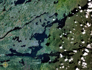
| Description | Lake Nemiscau, Quebec, Canada. Taken prior to diversion of Rupert River, which enters the lake at the bottom right and leaving the lake at the top middle, flowing to the left (west). |
| Source | NASA WorldWind |
| Author | NASA WorldWind |
| This image is in the public domain because it is a screenshot from NASA’s globe software World Wind using a public domain layer, such as Blue Marble, MODIS, Landsat, SRTM, USGS or GLOBE.
|
 |
File history
Click on a date/time to view the file as it appeared at that time.
| Date/Time | Thumbnail | Dimensions | User | Comment | |
|---|---|---|---|---|---|
| current | 18:24, 11 June 2007 | | 1,280 × 986 (2.57 MB) | P199 (talk | contribs) | {{Information |Description=Lake Nemiscau, Quebec, Canada. Taken prior to diversion of Rupert River. |Source=NASA WorldWind |Date= |Author= |Permission= |other_versions= }} {{PD-WorldWind}} Category:Lakes of Québec |
You cannot overwrite this file.
File usage on Commons
The following page uses this file:
File usage on other wikis
The following other wikis use this file:
- Usage on en.wikipedia.org
- Usage on fr.wikipedia.org
- Usage on www.wikidata.org