File:Netherlands, Kaag en Braassem, Ade en Oude Ade.png
Jump to navigation
Jump to search
Size of this preview: 711 × 599 pixels. Other resolutions: 285 × 240 pixels | 569 × 480 pixels | 911 × 768 pixels | 1,215 × 1,024 pixels | 2,429 × 2,048 pixels | 2,856 × 2,408 pixels.
Original file (2,856 × 2,408 pixels, file size: 2.77 MB, MIME type: image/png)
Captions
Captions
Add a one-line explanation of what this file represents
Summary
[edit]
| Description |
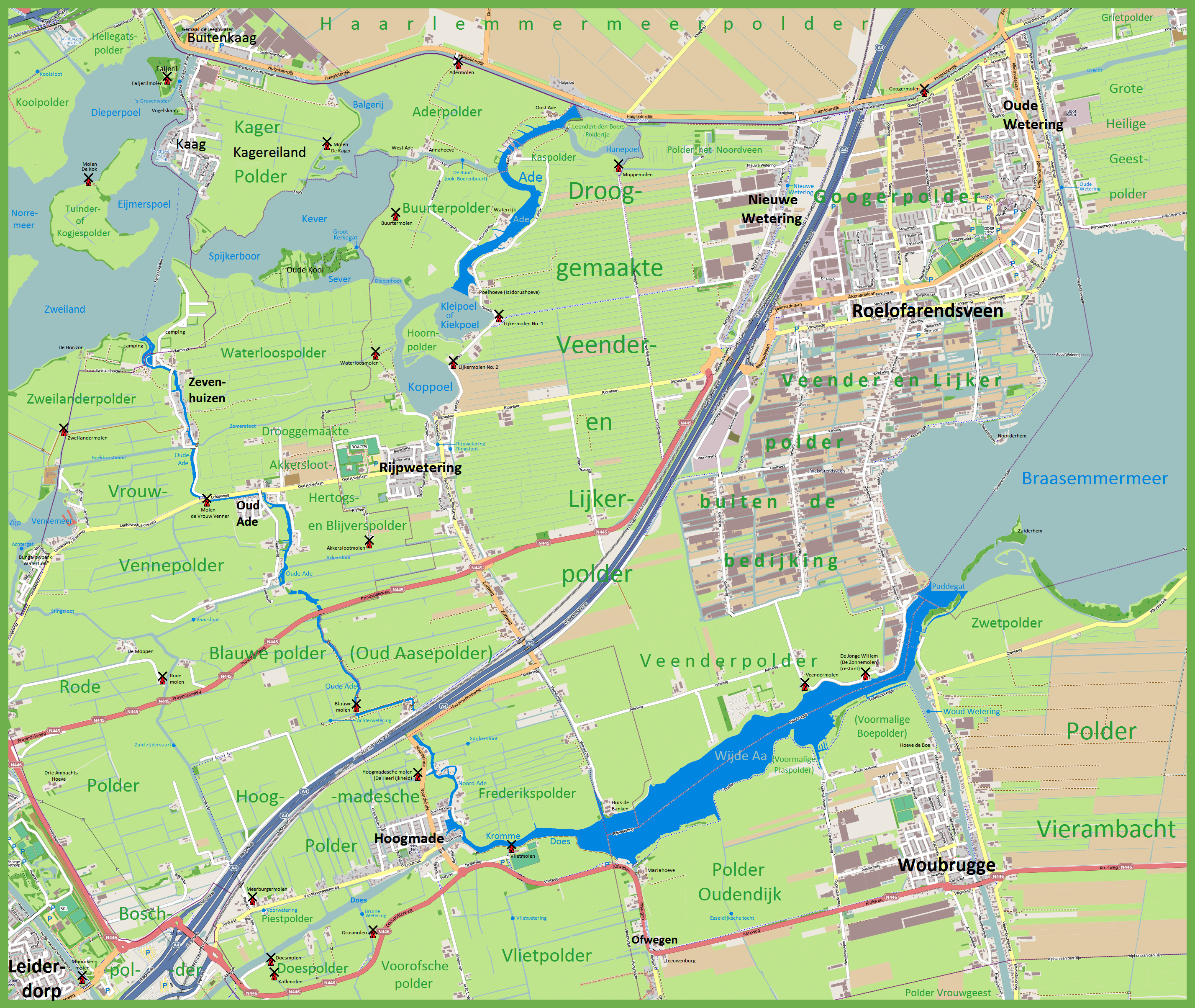
Nederlands: De Ade en Oude Ade (beiden in donkerblauw op deze kaart) zijn natuurlijke watergangen in de gemeente Kaag en Braassem (Provincie Zuid Holland). De Oude Ade is 9,55 km lang liep oorspronkelijk van het Braassemmermeer naar de Kager plas Zweiland maar is reeds lang geleden uit overwegingen van waterbeheer in diverse stukken geknipt met verschillende waterniveau's en draagt diverse namen op delen van haar loop. Op sommige plaatsen resteert er niet veel meer van dan een sloot. De Ade is slechts 2,0 km lang en vormt de verbinding tussen tussen de Kiekpoel of Kleipoel (een Kager plas) en de Ringvaart van de Haarlemmermeerpolder. De kaart geeft de namen van diverse andere wateren in dit gebied, van polders, molens, dorpen ed.
English: The Ade and Oude Ade (both in dark blue on this map) are natural waterways in the municipality of Kaag and Braassem (Province of South Holland, Netherlands). The Oude Ade (Old Ade) is 9.55 km long and ran originally from the Braassemmermeer (Lake Braassem) to Lake Zweiland but has long ago -for reasons of water management- been cut into several pieces with different water levels and different names. In some places little more than a ditch remains. The Ade is only 2,0 km long and forms the connection between the Kiekpoel or Kleipoel (a small lake) and the circular canal of the huge Haarlemmermeer Polder. The map shows the names of several other water bodies in this area, as well as polders, windmills, villages etc. |
| Date | |
| Source | www.openstreetmap.org, adapted by author. |
| Author | Vincent van Zeijst, adding to Openstreetmap.org |
| Permission (Reusing this file) |
The background map is taken from www.openstreetmap.org (which is in the public domain) to which additions were made. |
The center of this map is at:
| Camera location | | View this and other nearby images on: OpenStreetMap |
|---|
Licensing
[edit]
I, the copyright holder of this work, hereby publish it under the following license:
This file is licensed under the Creative Commons Attribution-Share Alike 3.0 Unported license.
- You are free:
- to share – to copy, distribute and transmit the work
- to remix – to adapt the work
- Under the following conditions:
- attribution – You must give appropriate credit, provide a link to the license, and indicate if changes were made. You may do so in any reasonable manner, but not in any way that suggests the licensor endorses you or your use.
- share alike – If you remix, transform, or build upon the material, you must distribute your contributions under the same or compatible license as the original.
File history
Click on a date/time to view the file as it appeared at that time.
| Date/Time | Thumbnail | Dimensions | User | Comment | |
|---|---|---|---|---|---|
| current | 23:01, 28 February 2012 | | 2,856 × 2,408 (2.77 MB) | Loranchet (talk | contribs) | {{Information |Description ={{nl|1=De Ade en Oude Ade (beiden in donkerblauw op deze kaart) zijn natuurlijke watergangen in de gemeente Kaag en Braassem (Provincie Zuid Holland). De Oude Ade is 9,55 km lang liep oorspronkelijk van het Braassemmermee... |
You cannot overwrite this file.
File usage on Commons
There are no pages that use this file.
File usage on other wikis
The following other wikis use this file:
- Usage on nl.wikipedia.org