File:New Caledonia (MODIS 2018-09-04).jpg

Original file (3,825 × 2,990 pixels, file size: 1.45 MB, MIME type: image/jpeg)
Captions
Captions
Summary
[edit].jpg&action=edit§ion=1)
| Description |
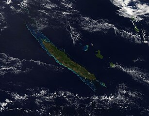
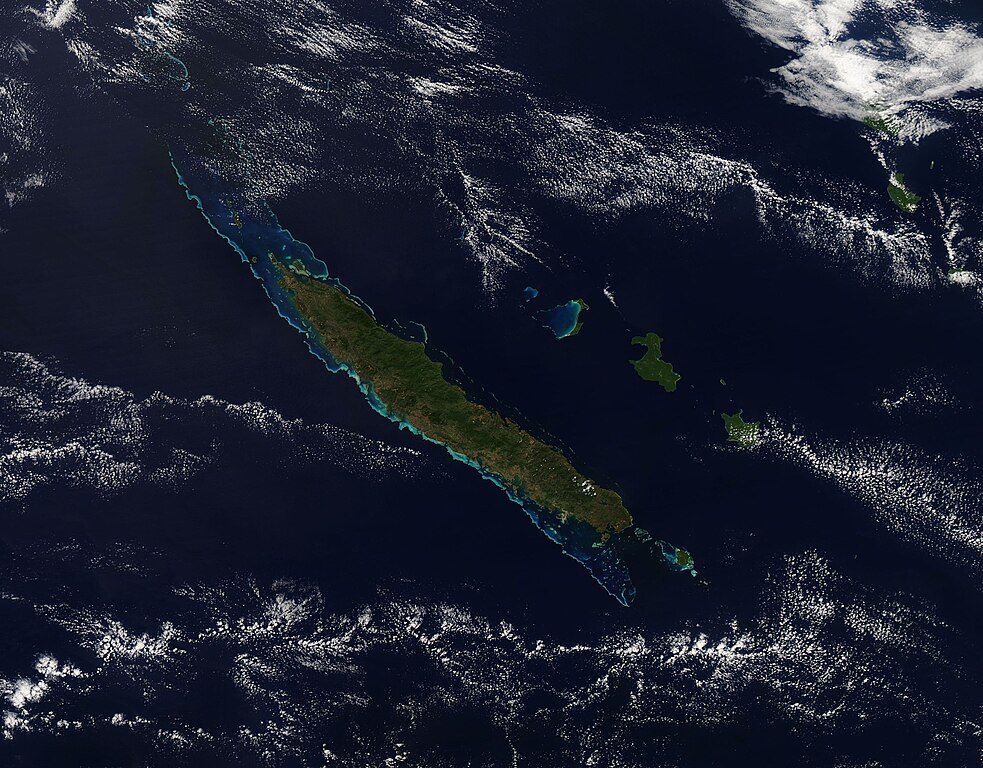
English: On August 31, 2018, the Moderate Resolution Imaging Spectroradiometer (MODIS) on board NASA’s Terra satellite acquired a true-color image of New Caledonia’s brilliant blue-encrusted landscape peeking through clouds.
New Caledonia sits in the South Pacific Ocean about 750 mi (1,200 km) east of Australia. The French territory encompasses many islands and islets scattered around the largest, long, island. Named Grande Terre, this beautiful cigar-shaped island is surrounded by one of the largest barrier reefs in the world, which stretches more than 800 mi (1,300 km) and appears jewel-blue from space. While the beauty of the coasts, reefs, and lagoons fuel a rich tourist economy, the highlands of Grande Terre contain large reserves of nickel and chromium, supporting an active mining industry. The lagoons and reefs of New Caledonia were added to the UNESCO World Heritage Site list in 2008. The lagoons comprise six marine clusters that represent the main diversity of coral reefs and associated ecosystems in New Caledonia, which is home to one of the three most extensive reef systems in the world. The lagoons and reefs feature a remarkable diversity of coral and fish species as well as a diversity of habitats, including mangroves and seagrasses. The area also claims the world’s most diverse concentration of reef structures which provide habitat to a large variety of sea life, including emblematic or threatened marine species, including turtles, whales, and dugongs. |
||
| Date | Taken on 31 August 2018 | ||
| Source |
|
||
| Author | MODIS Land Rapid Response Team, NASA GSFC |
| This media is a product of the Terra mission Credit and attribution belongs to the mission team, if not already specified in the "author" row |
Licensing
[edit].jpg&action=edit§ion=2)
| This file is in the public domain in the United States because it was solely created by NASA. NASA copyright policy states that "NASA material is not protected by copyright unless noted". (See Template:PD-USGov, NASA copyright policy page or JPL Image Use Policy.) | ||
 |
Warnings:
|
File history
Click on a date/time to view the file as it appeared at that time.
| Date/Time | Thumbnail | Dimensions | User | Comment | |
|---|---|---|---|---|---|
| current | 01:32, 17 February 2024 | | 3,825 × 2,990 (1.45 MB) | OptimusPrimeBot (talk | contribs) | #Spacemedia - Upload of http://modis.gsfc.nasa.gov/gallery/images/image09042018_250m.jpg via Commons:Spacemedia |
You cannot overwrite this file.
File usage on Commons
There are no pages that use this file.
.jpg&oldid=852770618)