File:New Caledonia (MODIS 2019-10-04).jpg

Original file (3,414 × 2,665 pixels, file size: 881 KB, MIME type: image/jpeg)
Captions
Captions
Summary
[edit].jpg&action=edit§ion=1)
| Description |
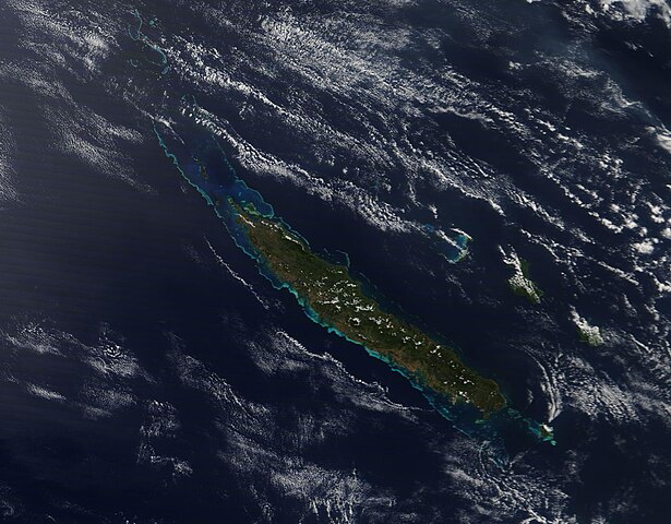
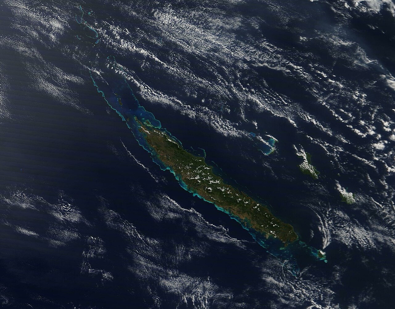
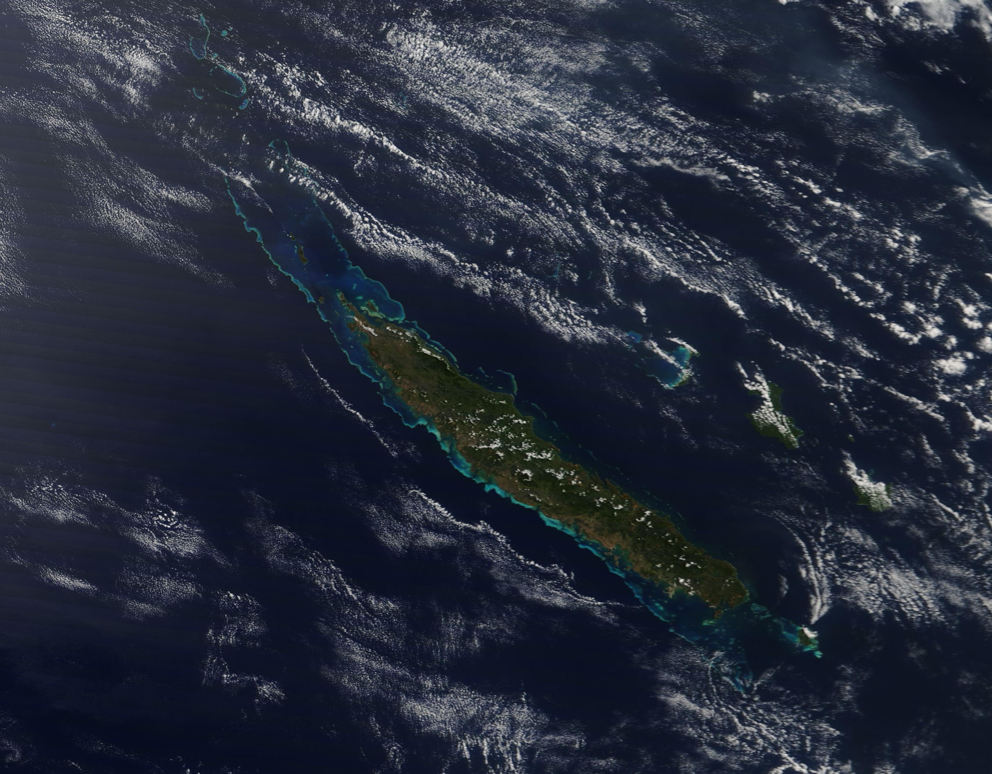
English: The island of New Caledonia, also called Grande Terre, sits in the southwest Pacific Ocean roughly 830 miles (1,300 km) east of Australia. The largest island of the archipelago of New Caledonia—indeed, one of the largest in the Pacific—the emerald-green Grande Terre extends about 250 miles (400 km) in a northwest to southeast orientation. It is ringed by a stunning, bright-blue coral reef that measures about 1,000 miles (1,600 km) long. New Caledonia consists of Grand Terre as well as four groups of sparsely populated islands, each containing numerous small islands and atolls.
The plant life of New Caledonia is unique, with about 75 percent of the plant species found nowhere else in the world, putting it third, after Hawaii and New Zealand, for endemic plant species. Marine life around Grand Terre and throughout New Caledonia rivals the uniqueness and importance of the plant life. In 2008, the United Nations Educational, Scientific and Cultural Organization (UNESCO) designated New Caledonia’s lagoons, reefs and associated ecosystems as a World Heritage site, describing it as one of the three most extensive reef systems in the world, and containing the world’s most diverse concentration of reef structures. UNESCO also stated that the Lagoons of New Caledonia “provide habitat to a number of emblematic or threatened marine species such as turtles, whales or dugongs whose population here is the third largest in the world”. The effort to conserve the precious and unique marine ecosystem have not stopped with the inclusion as a UNESCO World Heritage Site, however. The Natural Park of the Coral Sea was established in 2014 and encompasses the entire 2.3 million square kilometer Economic Exclusive Zone of New Caledonia. In 2018, which was named the “International Year of the Reef”, the government of New Caledonia voted to establish four Marine Protected Areas that cover 28,000 square kilometers which would protect all of their reefs, including remote areas. This is part of measures taken to conserve the coral reefs threatened by commercial fishing, tourism, and global climate change, according to an article published in Forbes Magazine on August 17, 2018. On September 30, 2019, the Moderate Resolution Imaging Spectroradiometer (MODIS) on board NASA’s Terra satellite acquired a true-color image of the island of New Caledonia (Grand Terre) surrounded by sparkling coral reef. |
||
| Date | Taken on 30 September 2019 | ||
| Source |
|
||
| Author | MODIS Land Rapid Response Team, NASA GSFC |
| This media is a product of the Terra mission Credit and attribution belongs to the mission team, if not already specified in the "author" row |
Licensing
[edit].jpg&action=edit§ion=2)
| This file is in the public domain in the United States because it was solely created by NASA. NASA copyright policy states that "NASA material is not protected by copyright unless noted". (See Template:PD-USGov, NASA copyright policy page or JPL Image Use Policy.) | ||
 |
Warnings:
|
File history
Click on a date/time to view the file as it appeared at that time.
| Date/Time | Thumbnail | Dimensions | User | Comment | |
|---|---|---|---|---|---|
| current | 03:00, 17 February 2024 | | 3,414 × 2,665 (881 KB) | OptimusPrimeBot (talk | contribs) | #Spacemedia - Upload of http://modis.gsfc.nasa.gov/gallery/images/image10042019_250m.jpg via Commons:Spacemedia |
You cannot overwrite this file.
File usage on Commons
There are no pages that use this file.
.jpg&oldid=852770632)