File:New York state geographic map-en.svg

Pradinė rinkmena (SVG rinkmena, formaliai 2 811 × 2 000 taškų, rinkmenos dydis: 18,34 MiB)
Captions
Captions
Aprašymas[keisti]
| Description |
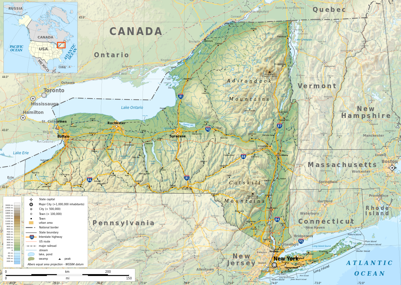
English: Geographic map of New York state in English. Geographic limits of the map:
|
| Data | |
| Šaltinis |
Mano darbas
|
| Kūrėjas | |
| Leidimas (Šios rinkmenos panaudojimas kitur) |
Any use of this map is subject of the license(s) stated below with the condition that you credit (Wikimedia Commons user: Ikonact) as the author . A message with a reply address would also be greatly appreciated. |
| Georeferencing | If inappropriate please set warp_status = skip to hide. |
|

|
Šiame SVG faile yra išverstas įterptasis tekstas. Šį tekstą galite išversti ir į savo kalbą, naudodami SVG vertimo įrankį ar kitus SVG redaktorius. Daugiau informacijos rasite apsilankę: Apie SVG failų vertimą. |
Licencija[keisti]
| This work contains information from OpenStreetMap, which is made available under the Open Database License (ODbL).
The ODbL does not require any particular license for maps produced from ODbL data. Prior to 1 August 2020, map tiles produced by the OpenStreetMap Foundation were licensed under the CC-BY-SA-2.0 license. Maps produced by other people may be subject to other licences. |
- Jūs galite:
- dalintis – kopijuoti, platinti bei persiųsti šį darbą
- pri(si)taikyti – adaptuoti darbą
- Su šiomis sąlygomis:
- autoriaus nurodymas – Turite pateikti atitinkamą kreditą, pateikti nuorodą į licenciją ir nurodyti, ar buvo atlikti pakeitimai. Tai galite padaryti bet kokiu būdu, bet ne taip, kad licencijos išdavėjas patvirtintų jus ar jūsų naudojimą.
- dalinkis panašiai – Jei perdirbsite, redaguosite ar atkursite šį darbą, jį galėsite platinti tik su tokia pačia ar panašia į šią licencija.
Rinkmenos istorija
Paspauskite ant datos/laiko, kad pamatytumėte rinkmeną tokią, kokia ji buvo tuo metu.
| Data/Laikas | Miniatiūra | Matmenys | Naudotojas | Paaiškinimas | |
|---|---|---|---|---|---|
| dabartinis | 12:15, 2 lapkričio 2023 | | 2 811 × 2 000 (18,34 MiB) | Ikonact (aptarimas | indėlis) | corrected some typos in names // Editing SVG source code using c:User:Rillke/SVGedit.js |
| 10:22, 14 spalio 2019 |  | 2 811 × 2 000 (18,41 MiB) | Ikonact (aptarimas | indėlis) | better dealing with fall back font | |
| 21:19, 12 spalio 2019 |  | 2 811 × 2 000 (20,53 MiB) | Ikonact (aptarimas | indėlis) | + fall back font, more towns and islands, provinces | |
| 23:33, 11 spalio 2019 |  | 2 811 × 2 000 (20,47 MiB) | Ikonact (aptarimas | indėlis) | error corrected | |
| 23:23, 11 spalio 2019 |  | 2 811 × 2 000 (20,47 MiB) | Ikonact (aptarimas | indėlis) | river and lake names added | |
| 21:58, 8 spalio 2019 |  | 2 811 × 2 000 (20,33 MiB) | Ikonact (aptarimas | indėlis) | some improvements, roads and cities in Canada | |
| 07:40, 22 rugsėjo 2019 |  | 2 811 × 2 000 (14,39 MiB) | Ikonact (aptarimas | indėlis) | small corrections | |
| 20:49, 21 rugsėjo 2019 |  | 2 811 × 2 000 (14,39 MiB) | Ikonact (aptarimas | indėlis) | + road names | |
| 20:23, 21 rugsėjo 2019 |  | 2 811 × 2 000 (14,31 MiB) | Ikonact (aptarimas | indėlis) | +names | |
| 22:01, 20 rugsėjo 2019 |  | 2 811 × 2 000 (15,37 MiB) | Ikonact (aptarimas | indėlis) | == {{int:filedesc}} == {{Information |description={{en|1=Geographic map of New York state in English. Geographic limits of the map:}} *N: 45.30° N *S: 40.30° N *W: 80.20° W *E: 71.00° W Albers equal area projection; WGS 84 datum |date=2019-09-21 |source={{own}} *Sources of data:<br/> **Topography: ETOPO1 (public domain);<br/> **Public domain data provided by the National Atlas of the United States of America;<br/> *Tool:<br/> **The map is created with Octave scripts d... |
Jūs negalite perrašyti šios rinkmenos.
Rinkmenos naudojimas
Daugiau nei 100 puslapių naudoja šią rinkmeną. Šis sąrašas rodo tik pirmus 100 puslapių, naudojančių šį failą. Yra pasiekiamas ir visas sąrašas.
- User talk:Ikonact
- Commons:Featured pictures/Non-photographic media/Maps
- Category:1879 in New York (state)
- Category:1880 in New York (state)
- Category:1899 in New York (state)
- Category:1900 in New York (state)
- Category:1901 in New York (state)
- Category:1902 in New York (state)
- Category:1903 in New York (state)
- Category:1904 in New York (state)
- Category:1905 in New York (state)
- Category:1906 in New York (state)
- Category:1907 in New York (state)
- Category:1908 in New York (state)
- Category:1909 in New York (state)
- Category:1910 in New York (state)
- Category:1911 in New York (state)
- Category:1914 in New York (state)
- Category:1916 in New York (state)
- Category:1917 in New York (state)
- Category:1918 in New York (state)
- Category:1919 in New York (state)
- Category:1921 in New York (state)
- Category:1944 in New York (state)
- Category:1954 in New York (state)
- Category:1963 in New York (state)
- Category:2007 in New York (state)
- Category:Archaeological sites in New York (state)
- Category:Art of New York (state)
- Category:Baseball in New York (state)
- Category:Basketball players from New York (state)
- Category:Beaches of New York (state)
- Category:Bodies of water in New York (state)
- Category:Botanical gardens in New York (state)
- Category:Bridges in New York (state)
- Category:Buildings in New York (state)
- Category:Canals in New York (state)
- Category:Cemeteries in New York (state)
- Category:Churches in New York (state)
- Category:Cities in New York (state)
- Category:Culture of New York (state)
- Category:Dams in New York (state)
- Category:Energy in New York (state)
- Category:Flora of New York (state)
- Category:Fountains in New York (state)
- Category:Higher education institutions in New York (state)
- Category:Hospitals in New York (state)
- Category:Ice hockey venues in New York (state)
- Category:Indoor arenas in New York (state)
- Category:Islands of New York (state)
- Category:Lakes of New York (state)
- Category:Libraries in New York (state)
- Category:Lighthouses in New York (state)
- Category:Maps of New York (state)
- Category:Mountains of New York (state)
- Category:National Historic Landmarks in New York (state)
- Category:New York (state)
- Category:New York (state) by decade
- Category:New York (state) in the 1770s
- Category:New York (state) in the 1780s
- Category:New York (state) in the 1790s
- Category:New York (state) in the 17th century
- Category:New York (state) in the 1800s
- Category:New York (state) in the 1810s
- Category:New York (state) in the 1820s
- Category:New York (state) in the 1830s
- Category:New York (state) in the 1840s
- Category:New York (state) in the 1850s
- Category:New York (state) in the 1860s
- Category:New York (state) in the 1870s
- Category:New York (state) in the 1880s
- Category:New York (state) in the 1890s
- Category:New York (state) in the 18th century
- Category:New York (state) in the 1900s
- Category:New York (state) in the 1910s
- Category:New York (state) in the 1920s
- Category:New York (state) in the 1940s
- Category:New York (state) in the 1950s
- Category:New York (state) in the 1960s
- Category:New York (state) in the 1970s
- Category:New York (state) in the 1980s
- Category:New York (state) in the 1990s
- Category:New York (state) in the 19th century
- Category:New York (state) in the 2000s
- Category:New York (state) in the 20th century
- Category:New York (state) in the 21st century
- Category:Nuclear power plants in New York (state)
- Category:Parks in New York (state)
- Category:Piers in New York (state)
- Category:Rail transport in New York (state)
- Category:Religion in New York (state)
- Category:Reservoirs in New York (state)
- Category:Rivers of New York (state)
- Category:Roads in New York (state)
- Category:Schools in New York (state)
- Category:Streets in New York (state)
- Category:Towers in New York (state)
- Category:Tunnels in New York (state)
- Category:Water transport in New York (state)
- Category:Waterfalls in New York (state)
Žiūrėti daugiau nuorodų į šį failą.
Visuotinis rinkmenos naudojimas
Ši rinkmena naudojama šiose viki svetainėse:
- Naudojama af.wikipedia.org
- Naudojama ang.wikipedia.org
- Naudojama az.wikipedia.org
- Naudojama be.wikipedia.org
- Naudojama bg.wikipedia.org
- Naudojama bn.wikipedia.org
- Naudojama ca.wikipedia.org
- Naudojama en.wikipedia.org
- Naudojama eo.wikipedia.org
- Naudojama fr.wikipedia.org
- Naudojama ga.wikipedia.org
- Naudojama gl.wikipedia.org
- Naudojama ha.wikipedia.org
- Naudojama hu.wikipedia.org
- Naudojama hy.wikipedia.org
- Naudojama id.wikipedia.org
- Naudojama lt.wikipedia.org
- Naudojama mhr.wikipedia.org
- Naudojama ml.wikipedia.org
- Naudojama os.wikipedia.org
- Naudojama pcd.wikipedia.org
- Naudojama pl.wikipedia.org
- Naudojama sh.wikipedia.org
- Naudojama tg.wikipedia.org
- Naudojama tr.wikipedia.org
- Naudojama tt.wikipedia.org
- Naudojama uk.wikipedia.org
- Naudojama www.wikidata.org