File:Newark Airport diagram extract.jpg
Jump to navigation
Jump to search

Size of this preview: 800 × 471 pixels. Other resolutions: 320 × 188 pixels | 640 × 377 pixels | 995 × 586 pixels.
Original file (995 × 586 pixels, file size: 102 KB, MIME type: image/jpeg)
Captions
Captions
Add a one-line explanation of what this file represents
| Description |
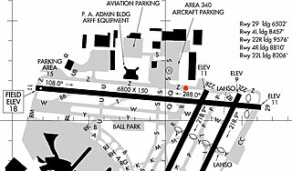
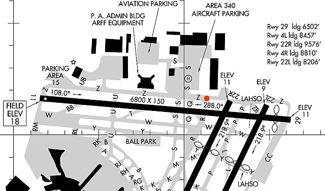
English: Extract from FAA KEWR Airport Diagram - added red dot on intersection of Taxiway R and Z.
|
| Source | |
| Author |
Licensing
[edit]
This image or file is a work of a Federal Aviation Administration employee, taken or made as part of that person's official duties. As a work of the U.S. federal government, the image is in the public domain in the United States.
|
 |
Original upload log
[edit]
The original description page was here. All following user names refer to en.wikipedia.
- 2006-11-12 22:27 Crum375 995×586× (104192 bytes) Extract from FAA KEWR Airport Diagram - added red dot on intersection of Taxiway R and Z.
File history
Click on a date/time to view the file as it appeared at that time.
| Date/Time | Thumbnail | Dimensions | User | Comment | |
|---|---|---|---|---|---|
| current | 12:42, 13 April 2010 | | 995 × 586 (102 KB) | File Upload Bot (Magnus Manske) (talk | contribs) | {{BotMoveToCommons|en.wikipedia|year={{subst:CURRENTYEAR}}|month={{subst:CURRENTMONTHNAME}}|day={{subst:CURRENTDAY}}}} {{Information |Description={{en|Extract from FAA KEWR Airport Diagram - added red dot on intersection of Taxiway R and Z. <br> Source: |
You cannot overwrite this file.
File usage on Commons
The following page uses this file:
- File:Newark Airport.jpg (file redirect)
File usage on other wikis
The following other wikis use this file:
- Usage on de.wikipedia.org
- Usage on en.wikipedia.org
- Usage on es.wikipedia.org