File:Niagara Falls (ASTER).jpg
Jump to navigation
Jump to search

Size of this preview: 634 × 600 pixels. Other resolutions: 254 × 240 pixels | 508 × 480 pixels | 812 × 768 pixels | 1,083 × 1,024 pixels | 2,165 × 2,048 pixels | 3,762 × 3,558 pixels.
Original file (3,762 × 3,558 pixels, file size: 2.8 MB, MIME type: image/jpeg)
Captions
Captions
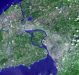
The Niagara River (a Native American word for «at the neck»), linking Lake Erie and Lake Ontario, flows around Niagara Island, and then plummets over Horseshoe and American Falls, better known as Niagara Falls.
Summary
[edit].jpg&action=edit§ion=1)
| Description |
English: The Niagara River (a Native American word for «at the neck»), linking Lake Erie and Lake Ontario, flows around Niagara Island, and then plummets over Horseshoe and American Falls, better known as Niagara Falls. The port city of Buffalo, New York is located at the northeast corner of Lake Erie where the river first leaves the lake. The image also includes the infamous Love Canal. In the late 1970s and early 1980s, as a result of chemical wastes having been dumped in the area of the Love Canal from 1947 to 1952, the area was evacuated. In 1990, after a 12-year cleanup effort, the federal government declared parts of the area habitable and reopened those areas. This image was acquired on September 8, 2001 and covers an area of 56.4 x 53.4 km. The image is centered at 43.1 degrees north latitude, 79 degrees west longitude. |
||
| Date | Taken on 8 September 2001 | ||
| Source |
|
||
| Author | NASA/METI/AIST/Japan Space Systems, and U.S./Japan ASTER Science Team |
| Camera location | | View this and other nearby images on: OpenStreetMap |
|---|
.jpg¶ms=043.100000_N_-079.000000_E_globe:Earth_type:camera__&language=en)
| This media is a product of the Terra mission Credit and attribution belongs to the Advanced Spaceborne Thermal Emission and Reflection Radiometer (ASTER) team, NASA/METI/AIST/Japan Space Systems |
Licensing
[edit].jpg&action=edit§ion=2)
| This file is in the public domain in the United States because it was solely created by NASA. NASA copyright policy states that "NASA material is not protected by copyright unless noted". (See Template:PD-USGov, NASA copyright policy page or JPL Image Use Policy.) | ||
 |
Warnings:
|
File history
Click on a date/time to view the file as it appeared at that time.
| Date/Time | Thumbnail | Dimensions | User | Comment | |
|---|---|---|---|---|---|
| current | 16:28, 7 May 2023 | | 3,762 × 3,558 (2.8 MB) | OptimusPrimeBot (talk | contribs) | #Spacemedia - Upload of https://asterweb.jpl.nasa.gov/gallery/images/niagara.jpg via Commons:Spacemedia |
You cannot overwrite this file.
File usage on Commons
There are no pages that use this file.
.jpg&oldid=769948784)