File:Nicole Soaks the Eastern United States (MODIS).jpg

Original file (3,410 × 3,228 pixels, file size: 1.62 MB, MIME type: image/jpeg)
Captions
Captions
Summary[edit]
.jpg&action=edit§ion=1)
| Description |
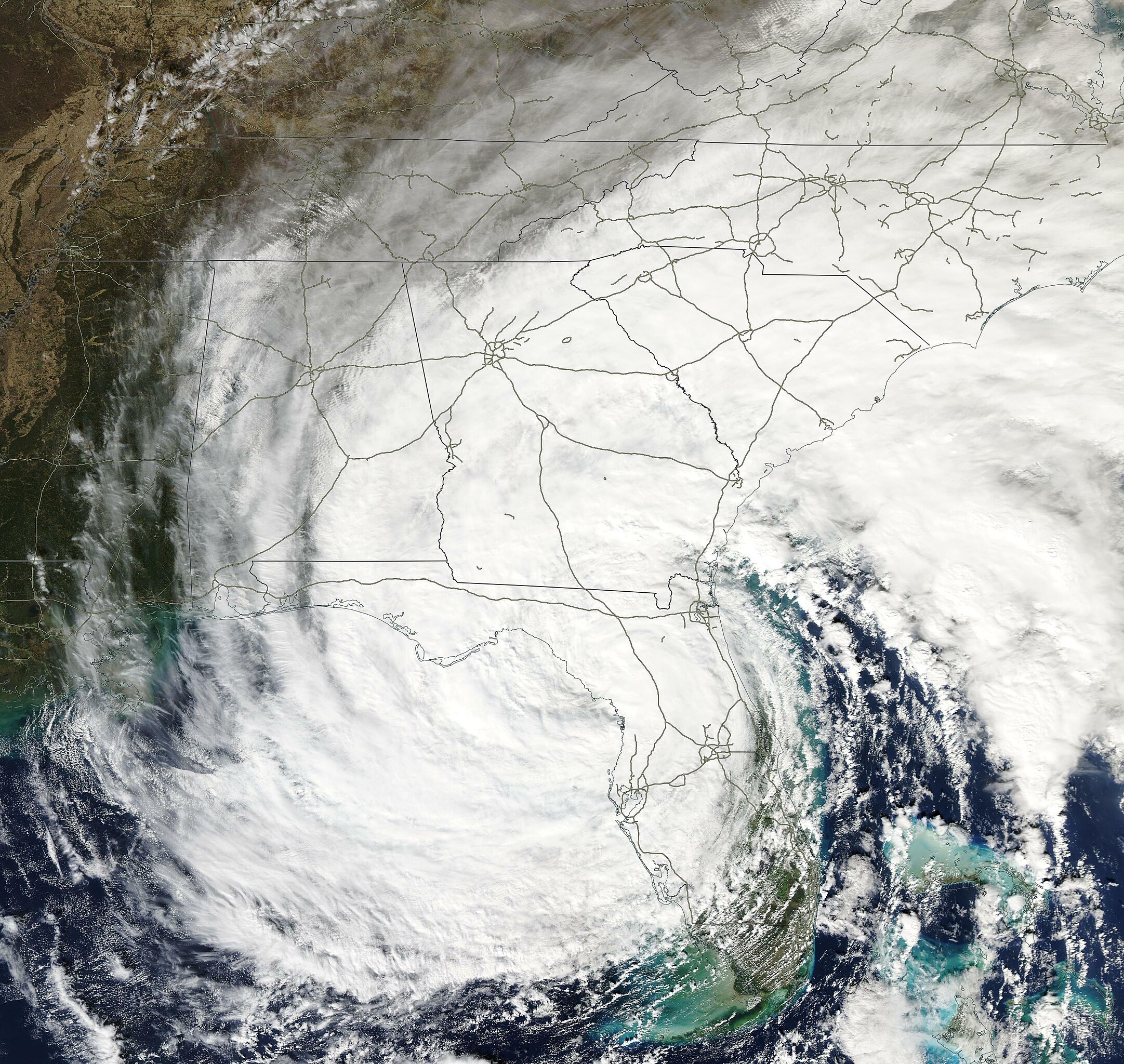
English: On November 10, 2022, the Moderate Resolution Imaging Spectroradiometer (MODIS) on board NASA’s Aqua satellite acquired a true-color image of Tropical Storm Nicole moving northward across the United States. Nicole was a remarkably large storm, with tropical-storm-force winds extending outwards up to 345 miles (555 km) from the center, especially to the northeast. This image shows convective bands and clouds stretching from southern Florida to Maryland and West Virginia. The a cloud-filled center of Nicole sits near Tampa on Florida’s west coast.
After making landfall near Vero Beach on Florida’s East Coast as a Category 1 hurricane with maximum sustained winds of 75 mph (121 km/h), the storm weakened as it crossed the state. According to the National Hurricane Center, near the time this image was acquired, Nicole had become a tropical storm and was carrying maximum sustained winds of 45 mph (70 km/h). It was located about 45 miles (70 km) north of Tampa, Florida and about 165 miles (265 km) southeast of Tallahassee, Florida and was moving northwest. By 10:00 p.m. EST on November 10, Nicole had further weakened to become a tropical depression with maximum sustained winds of 35 mph (55 mph). However, it remained a super-soaking storm as it crossed the U.S. Southeast and Mid-Atlantic states. According to meteorologist Jeff Masters, writing for Yale Climate Connections, “ Nicole was just the fourth hurricane on record to hit the contiguous U.S. after October, and the second-latest landfalling hurricane on record. Only Hurricane Kate in 1985, which hit the Florida Panhandle as a category 2 storm with 100 mph winds on November 21, made landfall later in the season.” Nicole brought a devastating storm surge which caused severe beach erosion to parts of Florida, especially Volusia County where beachfront homes were destroyed as the surge undercut the sand beneath the houses and parts of the roadway crumbled. Coastal flooding occurred as far north as Charleston, South Carolina, including record high water levels of 3.58 feet above high tide measured at Jacksonville, Florida. The storm was also responsible for the deaths of five people in Florida. |
||
| Date | Taken on 10 November 2022 | ||
| Source |
Nicole Soaks the Eastern United States (direct link)
|
||
| Author | MODIS Land Rapid Response Team, NASA GSFC |
| This media is a product of the Aqua mission Credit and attribution belongs to the mission team, if not already specified in the "author" row |
Licensing[edit]
.jpg&action=edit§ion=2)
| This file is in the public domain in the United States because it was solely created by NASA. NASA copyright policy states that "NASA material is not protected by copyright unless noted". (See Template:PD-USGov, NASA copyright policy page or JPL Image Use Policy.) | ||
 |
Warnings:
|
File history
Click on a date/time to view the file as it appeared at that time.
| Date/Time | Thumbnail | Dimensions | User | Comment | |
|---|---|---|---|---|---|
| current | 22:58, 6 September 2023 | | 3,410 × 3,228 (1.62 MB) | FooBarBaz (talk | contribs) | Cropped out swath line. |
| 21:40, 3 September 2023 |  | 4,202 × 3,228 (1.92 MB) | OptimusPrimeBot (talk | contribs) | #Spacemedia - Upload of http://modis.gsfc.nasa.gov/gallery/images/image11122022_500m.jpg via Commons:Spacemedia |
You cannot overwrite this file.
File usage on Commons
There are no pages that use this file.
.jpg&oldid=799104175)