File:Nieuwe kaart van het eiland Schouwe en aanhorige polders als mede van geheel Duiveland -- ten nauwkeurigsten afgemeten door ... Daniel Verburcht ; opnieuws opgenomen in ... 1747 ... door Corn. D. - KONB16-416958923 - Prent 1 van 1.jpg
Original file (1,500 × 671 pixels, file size: 226 KB, MIME type: image/jpeg)
Captions
Captions
Summary
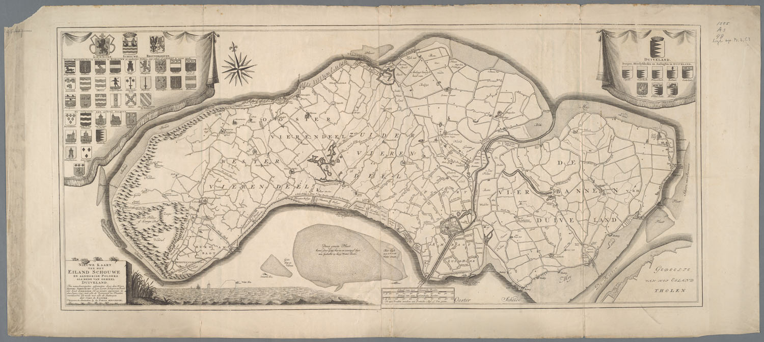
[edit]| Nieuwe kaart van het eiland Schouwe en aanhorige polders als mede van geheel Duiveland -- ten nauwkeurigsten afgemeten door ... Daniel Verburcht ; opnieuws opgenomen in ... 1747 ... door Corn. D. Kanter
( |
|||||||||||||||||||||
|---|---|---|---|---|---|---|---|---|---|---|---|---|---|---|---|---|---|---|---|---|---|
| Artist |
Creator(s) and/or contributor(s) of this object:
|
||||||||||||||||||||
| Author |
Printer(s) and/or publisher(s) of this object:
|
||||||||||||||||||||
| Title |
Nieuwe kaart van het eiland Schouwe en aanhorige polders als mede van geheel Duiveland -- ten nauwkeurigsten afgemeten door ... Daniel Verburcht ; opnieuws opgenomen in ... 1747 ... door Corn. D. Kanter |
||||||||||||||||||||
| Object type | map | ||||||||||||||||||||
| Description |
kopergravure --- Schaal [ongeveer 1:35.000] --- Met schaalstokken: Schaal van 1000 Schouwsche roeden = 180 mm, Schaal van 1000 Rynlandsche roeden = 120 mm. NB 1500 roeden maaken een Fransche myl of uur gaans --- Links boven: Wapens van Zierikzee, Schouwe, Brouwershaven en de dorpen, heerlykheden en ambagten in Schouwe en aanhoorige polders, nog geheel of gedeeltelyk in wezen zynde --- Rechts boven: Wapens van Duiveland en de dorpen, heerlykheden en ambagten in Duiveland |
||||||||||||||||||||
| Date | 1748 | ||||||||||||||||||||
| Collection |
|
||||||||||||||||||||
| Accession number |
|
||||||||||||||||||||
| Source/Photographer |
Source page of image: http://resolver.kb.nl/resolve?urn=urn:gvn:KONB16:416958923
|
||||||||||||||||||||

Licensing
[edit]
|
This is a faithful photographic reproduction of a two-dimensional, public domain work of art. The work of art itself is in the public domain for the following reason:
The official position taken by the Wikimedia Foundation is that "faithful reproductions of two-dimensional public domain works of art are public domain".
This photographic reproduction is therefore also considered to be in the public domain in the United States. In other jurisdictions, re-use of this content may be restricted; see Reuse of PD-Art photographs for details. | ||||
File history
Click on a date/time to view the file as it appeared at that time.
| Date/Time | Thumbnail | Dimensions | User | Comment | |
|---|---|---|---|---|---|
| current | 14:14, 5 October 2022 | | 1,500 × 671 (226 KB) | OlafJanssen (talk | contribs) | Creating new file "File:Nieuwe kaart van het eiland Schouwe en aanhorige polders als mede van geheel Duiveland -- ten nauwkeurigsten afgemeten door ... Daniel Verburcht ; opnieuws opgenomen in ... 1747 ... door Corn. D. - KONB16:416958923 - Prent 1 van 1.jpg" via API upload with custom Python script |
You cannot overwrite this file.
File usage on Commons
The following page uses this file: