File:Nieuwe kaarte vertoonende den geheelen Alblasserwaardt met de Vyf Heeren Landen samen groot 33110 mergen -- door Abel de Vries, landmeter te Dordrecht ; waar in de inundatien sedert het jaar 1500 - KONB16-41550872X - Prent 1 van 1.jpg

Original file (1,500 × 1,095 pixels, file size: 408 KB, MIME type: image/jpeg)
Captions
Captions
Summary
[edit]| Artist |
Creator(s) and/or contributor(s) of this object:
|
||||||||||||||||||||
| Author |
Printer(s) and/or publisher(s) of this object:
|
||||||||||||||||||||
| Title |
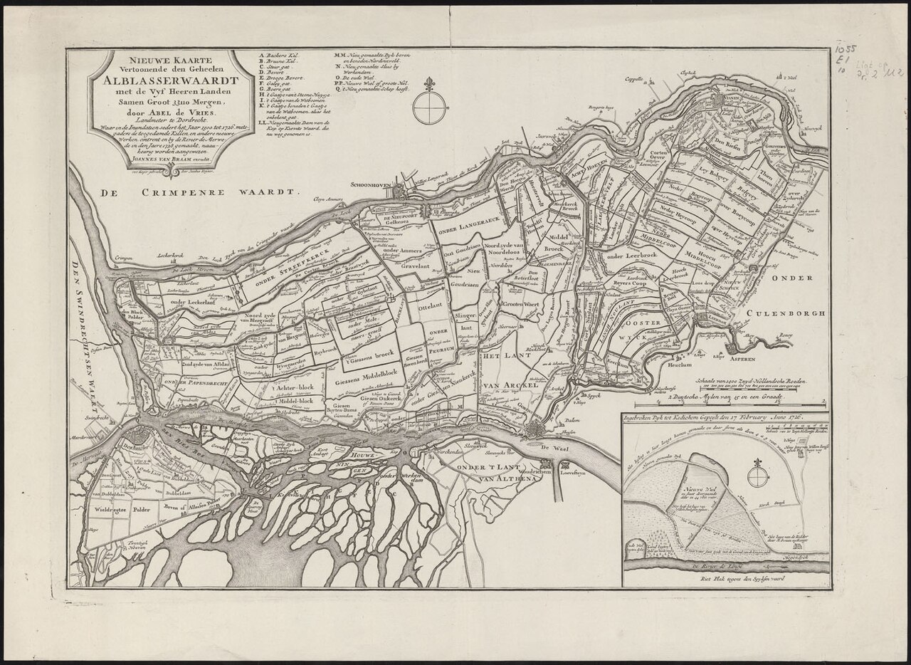
Nieuwe kaarte vertoonende den geheelen Alblasserwaardt met de Vyf Heeren Landen samen groot 33110 mergen -- door Abel de Vries, landmeter te Dordrecht ; waar in de inundatien sedert het jaar 1500 tot 1726, mitsgaders de toegedamde killen, en andere nieuwe werken, omtrent en by de rivier de Merwede in den jaere 1738 gemaakt, naaukeurig worden aangewezen ; Joannes van Braam excudit ; in t' koper gebracht door Jacobus Keyser |
||||||||||||||||||||
| Object type | map | ||||||||||||||||||||
| Description |
kopergrav --- Met 2 schaalstokken --- Legenda: A-Q --- Schaal [ca. 1:95.000] --- Inzet: Ingebroken dyk tot Kedichem gepeylt den 17 February anno 1726 |
||||||||||||||||||||
| Date | circa 1740 | ||||||||||||||||||||
| Dimensions | height: 31 cm (12.2 in); width: 44 cm (17.3 in) | ||||||||||||||||||||
| Collection |
|
||||||||||||||||||||
| Accession number |
|
||||||||||||||||||||
| Notes | This object is about the location (in Dutch): Alblasserwaard | ||||||||||||||||||||
| References | Koeman, Handleiding voor de studie van de topografische kaarten van Nederland, 1750-1850, nr. 39 | ||||||||||||||||||||
| Source/Photographer |
Source page of image: http://resolver.kb.nl/resolve?urn=urn:gvn:KONB16:41550872X
|
||||||||||||||||||||

Licensing
[edit]
|
This is a faithful photographic reproduction of a two-dimensional, public domain work of art. The work of art itself is in the public domain for the following reason:
The official position taken by the Wikimedia Foundation is that "faithful reproductions of two-dimensional public domain works of art are public domain".
This photographic reproduction is therefore also considered to be in the public domain in the United States. In other jurisdictions, re-use of this content may be restricted; see Reuse of PD-Art photographs for details. | ||||
File history
Click on a date/time to view the file as it appeared at that time.
| Date/Time | Thumbnail | Dimensions | User | Comment | |
|---|---|---|---|---|---|
| current | 14:43, 5 October 2022 | | 1,500 × 1,095 (408 KB) | OlafJanssen (talk | contribs) | Creating new file "File:Nieuwe kaarte vertoonende den geheelen Alblasserwaardt met de Vyf Heeren Landen samen groot 33110 mergen -- door Abel de Vries, landmeter te Dordrecht ; waar in de inundatien sedert het jaar 1500 - KONB16:41550872X - Prent 1 van 1.jpg" via API upload with custom Python script |
You cannot overwrite this file.
File usage on Commons
The following page uses this file: