File:Nile River Delta (MODIS 2021-05-26).jpg
Jump to navigation
Jump to search

Size of this preview: 759 × 600 pixels. Other resolutions: 304 × 240 pixels | 607 × 480 pixels | 972 × 768 pixels | 1,280 × 1,012 pixels | 2,542 × 2,009 pixels.
Original file (2,542 × 2,009 pixels, file size: 287 KB, MIME type: image/jpeg)
Captions
Captions
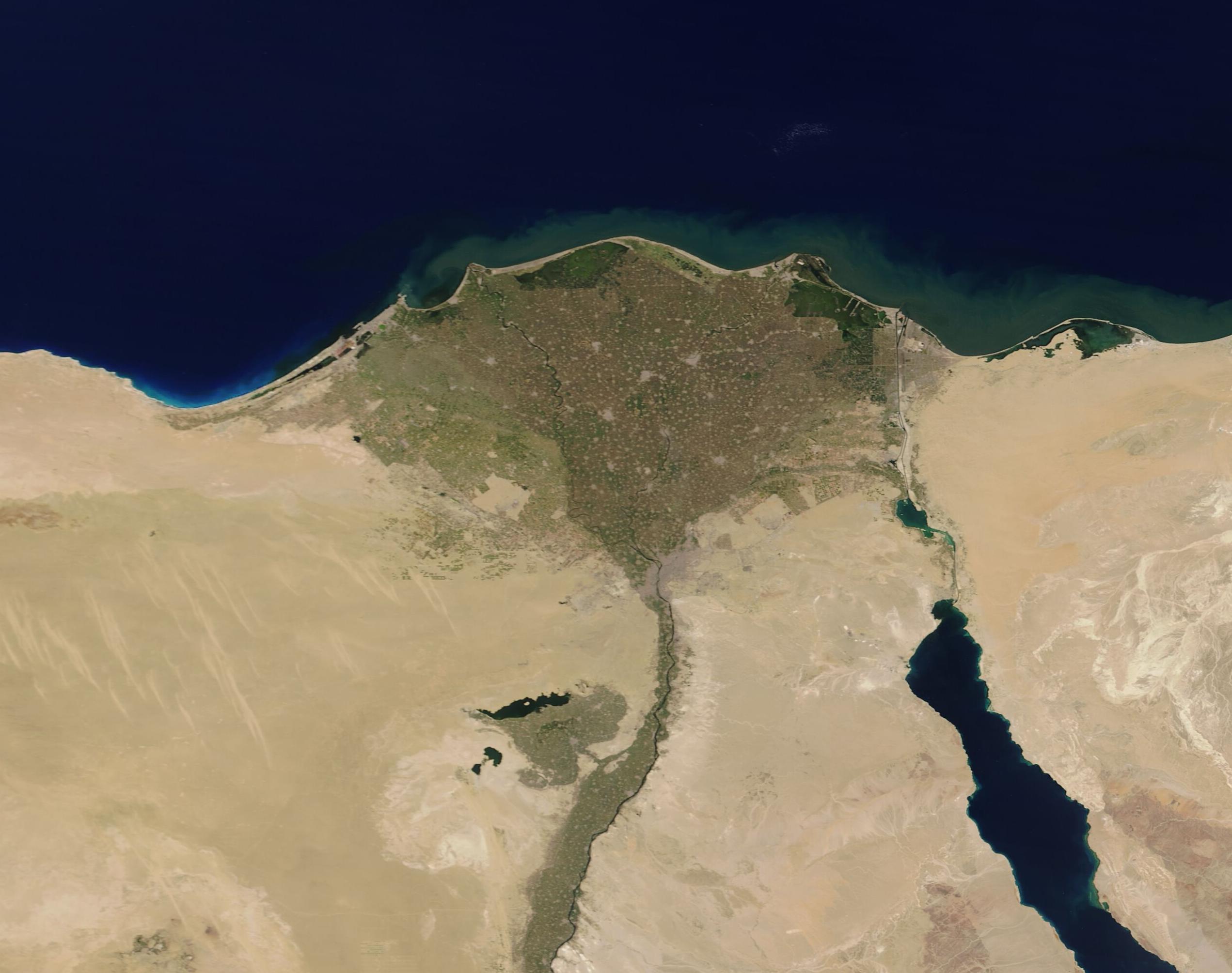
This stunning true-color image of the Nile River Delta, Egypt on a sunny late-spring day was acquired by the Moderate Resolution Imaging Spectroradiometer (MODIS) on board NASA’s Terra satellite.
Summary[edit]
.jpg&action=edit§ion=1)
| Description |
English: This stunning true-color image of the Nile River Delta, Egypt on a sunny late-spring day was acquired by the Moderate Resolution Imaging Spectroradiometer (MODIS) on board NASA’s Terra satellite. The expansive green delta of the Nile River blooms like a flower in the desert and is formed from the wide floodplain created as the Nile splits into the Rosetta (west) and Damietta (east) branches. By the time these branches reach the Mediterranean Sea, they sit roughly 87 miles (140 km) apart. The Delta spans roughly 10,039 square miles (26,000 square km).
Before the construction of the Aswan High Dam, which opened in 1970, the Nile River braided into many channels as it widened near the Egyptian city of Cairo. Flood waters would carry nutrient-rich sediment from the upper reaches of the river to the Delta where the sediment would be deposited across the entire flood plain. Today flow levels have been greatly reduced, even in flood season, and all that remains of the braids are several lakes. Despite the reduced flow, the Nile Delta remains extremely important for agriculture, fishing, habitat for wildlife, and is one of the world’s most important routes for migrating birds. It is also the most densely populated region of Egypt, with more than 39 million people calling the Delta home. In this image, vegetation appears green and arid desert looks tan. Light tan or gray smudges are the mark of human habitation, including the large city of Cairo located at the base of the Delta. |
||
| Date | Taken on 24 May 2021 | ||
| Source |
Nile River Delta (direct link)
|
||
| Author | MO'DIS Land Rapid Response Team, NASA GSFC |
| This media is a product of the Terra mission Credit and attribution belongs to the mission team, if not already specified in the "author" row |
Licensing[edit]
.jpg&action=edit§ion=2)
| This file is in the public domain in the United States because it was solely created by NASA. NASA copyright policy states that "NASA material is not protected by copyright unless noted". (See Template:PD-USGov, NASA copyright policy page or JPL Image Use Policy.) | ||
 |
Warnings:
|
File history
Click on a date/time to view the file as it appeared at that time.
| Date/Time | Thumbnail | Dimensions | User | Comment | |
|---|---|---|---|---|---|
| current | 17:45, 30 January 2024 | | 2,542 × 2,009 (287 KB) | OptimusPrimeBot (talk | contribs) | #Spacemedia - Upload of http://modis.gsfc.nasa.gov/gallery/images/image05262021_250m.jpg via Commons:Spacemedia |
You cannot overwrite this file.
File usage on Commons
There are no pages that use this file.
.jpg&oldid=847414057)