File:Nordrhein-Westfalen Flughäfen und Landeplätze.png
Jump to navigation
Jump to search

Size of this preview: 597 × 599 pixels. Other resolutions: 239 × 240 pixels | 478 × 480 pixels | 765 × 768 pixels | 1,020 × 1,024 pixels | 1,491 × 1,497 pixels.
Original file (1,491 × 1,497 pixels, file size: 662 KB, MIME type: image/png)
Captions
Captions
Add a one-line explanation of what this file represents
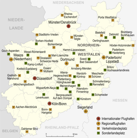
| Description | Flughäfen, Verkehrslandeplätze, Sonderlandeplätze und Wasserlandeplätze in Nordrhein-Westfalen, Stand 2007 |
| Date | |
| Source |
own work, used: |
| Author | Lencer |
| Other versions |
English: You may also find these files useful:
Deutsch: Eventuell gefallen ihnen auch folgende Karten:
|


This file is licensed under the Creative Commons Attribution-Share Alike 3.0 Unported license.
- You are free:
- to share – to copy, distribute and transmit the work
- to remix – to adapt the work
- Under the following conditions:
- attribution – You must give appropriate credit, provide a link to the license, and indicate if changes were made. You may do so in any reasonable manner, but not in any way that suggests the licensor endorses you or your use.
- share alike – If you remix, transform, or build upon the material, you must distribute your contributions under the same or compatible license as the original.

|
This map has been made or improved in the German Kartenwerkstatt (Map Lab). You can propose maps to improve as well.
|
[[Category:Maps of airports in North Rhine-Westphalia]
File history
Click on a date/time to view the file as it appeared at that time.
| Date/Time | Thumbnail | Dimensions | User | Comment | |
|---|---|---|---|---|---|
| current | 09:33, 25 February 2015 | | 1,491 × 1,497 (662 KB) | Lencer (talk | contribs) | Essen/Mühlheim => Essen/Mülheim |
| 12:25, 18 February 2015 |  | 1,494 × 1,500 (659 KB) | Lencer (talk | contribs) | Essen/Mülheim jetzt Verkehrslandeplatz | |
| 18:15, 20 March 2009 |  | 1,494 × 1,500 (662 KB) | Lencer (talk | contribs) | Name erg | |
| 12:05, 19 March 2009 |  | 1,494 × 1,500 (654 KB) | Lencer (talk | contribs) | {{Information| |Description=Flughäfen, Verkehrslandeplätze, Sonderlandeplätze und Wasserlandeplätze in Nordrhein-Westfalen, Stand 2007 |Source=own work, used: * [[:de:Liste der Verkehrs- und Sonderlandeplätze in Deutschland|Liste der Verkehrs- und So |
You cannot overwrite this file.
File usage on Commons
The following 7 pages use this file:
- User:Chumwa/OgreBot/Transport Maps/2015 February 10-18
- User:Chumwa/OgreBot/Transport Maps/2015 February 19-28
- Commons:WikiProject Aviation/recent uploads/2015 February 18
- Commons:WikiProject Aviation/recent uploads/2015 February 25
- File:Flughäfen in NRW.png
- File:NRW-Flughäfen.png
- File:North rhine w Airports.svg
File usage on other wikis
The following other wikis use this file:
- Usage on de.wikipedia.org
- Usage on hu.wikipedia.org