File:North Korean missile range.svg
跳至導覽
跳至搜尋

此 SVG 檔案的 PNG 預覽的大小:512 × 512 像素。 其他解析度:240 × 240 像素 | 480 × 480 像素 | 768 × 768 像素 | 1,024 × 1,024 像素 | 2,048 × 2,048 像素。
原始檔案 (SVG 檔案,表面大小:512 × 512 像素,檔案大小:163 KB)
說明
說明
添加單行說明來描述出檔案所代表的內容
摘要[編輯]
| 描述 |
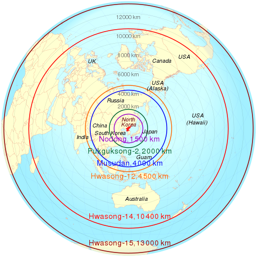
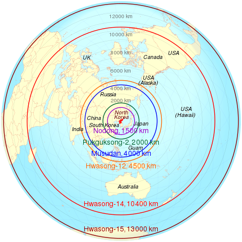
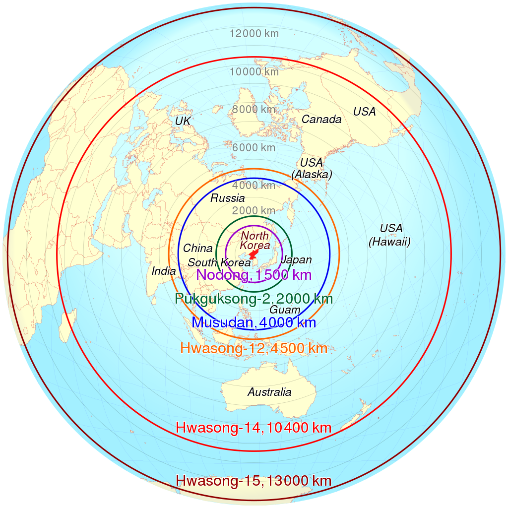
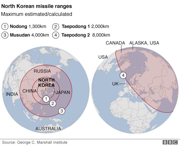
English: Azimuthal equidistant projection of estimated maximum range of some North Korean missiles based on data from http://ichef.bbci.co.uk/news/624/cpsprodpb/26F5/production/_88837990_north_korea_missile_ranges2_map624new.png . Deutsch: Geschätzte Reichweite nordkoreanischer Raketen auf Basis der folgenden Daten http://ichef.bbci.co.uk/news/624/cpsprodpb/26F5/production/_88837990_north_korea_missile_ranges2_map624new.png . |
||
| 日期 | |||
| 來源 | 我個人以下列物件為基礎來創作: North-korean-missile-ranges.svg 由 TUBS | ||
| 作者 | Cmglee | ||
| SVG開發 | 本向量圖形使用Other tools創作。 這個SVG 檔案使用了內置文字,可以使用任何文字編輯器輕鬆翻譯。
|
convert_absolute_to_relative_svg_path.py[編輯]
| Python2 source |
|---|
#!/usr/bin/env python
PATH_OUT = 'out.txt'
PATHD    = "..."
import re
pathds     = re.findall(r'[A-Z][^A-Za-z]+', '%s ' % (PATHD))
outs       = []
x_previous = None
y_previous = None
for (i_pathd, pathd) in enumerate(pathds):
 fields = (re.sub(r'([A-Z]+)', r'\1\t', re.sub(r'[\s,]+', '\t', pathd)).
           split('\t'))
 # print(fields)
 command = fields[0]
 if (fields[1] == '' or fields[2] == ''): ## "Z"
  outs.append(command)
 else:
  x = round(float(fields[1]))
  y = round(float(fields[2]))
  if (i_pathd == 0): ## first point
   outs.append('%s%d,%d' % (command, x, y))
  else:
   x_out   = x - x_previous
   y_out   = y - y_previous
   command = command.lower()
   if (command != 'l' or (x_out != 0 and y_out != 0)):
    outs.append('%s%d,%d' % (command, x_out, y_out))
   else:
    if   (x_out != 0): outs.append('h%d' % (x_out))
    elif (y_out != 0): outs.append('v%d' % (y_out))
    else:              pass ## same point after rounding
  x_previous = x
  y_previous = y
print(len(outs))
f_out = open(PATH_OUT, 'wt')
f_out.write(''.join(outs))
f_out.close()
|
授權條款[編輯]
我,本作品的著作權持有者,決定用以下授權條款發佈本作品:
此檔案採用創用CC 姓名標示-相同方式分享 3.0 未在地化版本授權條款。
- 您可以自由:
- 分享 – 複製、發佈和傳播本作品
- 重新修改 – 創作演繹作品
- 惟需遵照下列條件:
- 姓名標示 – 您必須指名出正確的製作者,和提供授權條款的連結,以及表示是否有對內容上做出變更。您可以用任何合理的方式來行動,但不得以任何方式表明授權條款是對您許可或是由您所使用。
- 相同方式分享 – 如果您利用本素材進行再混合、轉換或創作,您必須基於如同原先的相同或兼容的條款,來分布您的貢獻成品。

|
已授權您依據自由軟體基金會發行的無固定段落、封面文字和封底文字GNU自由文件授權條款1.2版或任意後續版本,對本檔進行複製、傳播和/或修改。該協議的副本列在GNU自由文件授權條款中。 |
您可以選擇您需要的授權條款。
原始上傳日誌[編輯]
This image is a derivative work of the following images:
- North Korea on the globe (Japan centered).svg licensed with Cc-by-sa-3.0, GFDL
- 2011-04-27T07:27:57Z TUBS 1246x1246 (1188392 Bytes)
.svg)
Uploaded with derivativeFX
檔案歷史
點選日期/時間以檢視該時間的檔案版本。
| 日期/時間 | 縮圖 | 尺寸 | 使用者 | 備註 | |
|---|---|---|---|---|---|
| 目前 | 2022年2月3日 (四) 08:14 | | 512 × 512(163 KB) | Cmglee(留言 | 貢獻) | Update as per http://bbc.com/news/world-asia-60193714#Advances-in-N-Koreas-missile-technology |
| 2017年7月5日 (三) 17:25 |  | 512 × 512(163 KB) | Cmglee(留言 | 貢獻) | Update Hwasong/KN-14 range. | |
| 2017年5月19日 (五) 18:01 |  | 512 × 512(162 KB) | Cmglee(留言 | 貢獻) | Add KN-08 and KN-14 from http://bbc.com/news/world-asia-17399847 | |
| 2017年5月11日 (四) 06:12 |  | 512 × 512(162 KB) | Cmglee(留言 | 貢獻) | Update ranges and map to azimuthal equidistant projection. | |
| 2013年4月4日 (四) 18:26 |  | 512 × 512(688 KB) | Cmglee(留言 | 貢獻) | Label Koreas. | |
| 2013年4月4日 (四) 12:52 |  | 512 × 512(688 KB) | Cmglee(留言 | 貢獻) | Add Guam and Hawaii. | |
| 2013年4月4日 (四) 12:28 |  | 512 × 512(688 KB) | Cmglee(留言 | 貢獻) | == {{int:filedesc}} == {{Information |Description={{de|Lage von XY (siehe Dateiname) auf der Erde.}} {{en|Location of XY (see filename) on the globe.}} |Source={{Derived from|North_Korea_on_the_globe_(Japan_centered).svg|disp... |
無法覆蓋此檔案。
檔案用途
下列5個頁面有用到此檔案:
全域檔案使用狀況
以下其他 wiki 使用了這個檔案:
- ar.wikipedia.org 的使用狀況
- ast.wikipedia.org 的使用狀況
- bg.wikipedia.org 的使用狀況
- ca.wikipedia.org 的使用狀況
- de.wikipedia.org 的使用狀況
- en.wikipedia.org 的使用狀況
- North Korea and weapons of mass destruction
- Hwasong-7
- Azimuthal equidistant projection
- User:Cmglee
- Korean People's Army Strategic Force
- Hwasong-10
- 2013 in North Korea
- User:Cmglee/svg
- Wikipedia:Miscellany for deletion/User:B3430715/Userboxes/privacy
- Hwasong-12
- 2018 Hawaii false missile alert
- Aegis system equipped vessels (ASEV)
- en.wikiquote.org 的使用狀況
- es.wikipedia.org 的使用狀況
- es.wikinews.org 的使用狀況
- fa.wikipedia.org 的使用狀況
- fi.wikipedia.org 的使用狀況
- fr.wikipedia.org 的使用狀況
- it.wikipedia.org 的使用狀況
- ja.wikipedia.org 的使用狀況
- ko.wikipedia.org 的使用狀況
- nl.wikipedia.org 的使用狀況
- no.wikipedia.org 的使用狀況
- pl.wikipedia.org 的使用狀況
- pt.wikipedia.org 的使用狀況
- ru.wikipedia.org 的使用狀況
- ru.wikinews.org 的使用狀況
- sr.wikipedia.org 的使用狀況
- sv.wikipedia.org 的使用狀況
檢視此檔案的更多全域使用狀況。