File:North america terrain 2003.jpg

پروندهٔ اصلی (۳٬۷۹۰ × ۲٬۹۲۲ پیکسل، اندازهٔ پرونده: ۱٫۹ مگابایت، نوع MIME پرونده: image/jpeg)
گزینهها
عنوان
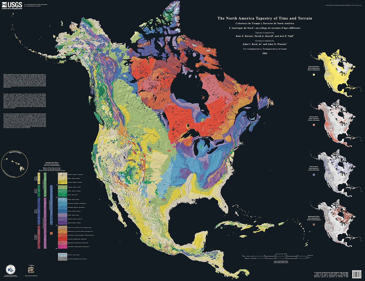
The North America Tapestry of Time and Terrain (1:8,000,000 scale) is a product of the United States Geological Survey in the I-map series (I-2781). This map was prepared in collaboration with the Geological Survey of Canada and the Mexican Consejo Recursos de Minerales.
This cartographic tapestry is woven from a geologic map and a shaded relief image. This digital combination reveals the geologic history of North America through the interrelation of rock type, topography and time. Regional surface processes as well as continent-scale tectonic events are exposed in the three dimensions of space and the fourth dimension, geologic time. The large map shows the varying age of bedrock underlying North America, while four smaller maps show the distribution of four principal types of rock: sedimentary, volcanic, plutonic and metamorphic.
Related images
[ویرایش]Four maps show the North American distribution of four principal types of rock: sedimentary, volcanic, plutonic and metamorphic.


There are separate images of the main map, time scale, and rock type maps.
-
 North American terrain
 -
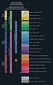 Time scale
 -
 North American rock types


Source
[ویرایش]
این تصویر در مالکیت عمومی است زیرا تنها پدیدآور آن سازمان زمینشناسی آمریکا است که یکی از سازمانهای وابسته به وزارت کشور ایالات متحده آمریکا به شمار میرود. برای اطلاعات بیشتر سیاستهای رسمی حق تکثیر سازمان زمینشناسی آمریکا را ببینید.
|
Home: http://pubs.usgs.gov/imap/i2781/
Image: http://pubs.usgs.gov/imap/i2781/i2781_c_low.pdf 144 dpi, encoded to 72 dpi JPEG, compressed slightly to fit within Wikipedia 2MB limit.
Source: English Wikipedia, original upload 15 April 2005 by SEWilco
تاریخچهٔ پرونده
روی تاریخ/زمانها کلیک کنید تا نسخهٔ مربوط به آن هنگام را ببینید.
| تاریخ/زمان | بندانگشتی | ابعاد | کاربر | توضیح | |
|---|---|---|---|---|---|
| کنونی | ۱۶ سپتامبر ۲۰۰۵، ساعت ۱۶:۰۴ | | ۳٬۷۹۰ در ۲٬۹۲۲ (۱٫۹ مگابایت) | Saperaud~commonswiki (بحث | مشارکتها) | The North America Tapestry of Time and Terrain (1:8,000,000 scale) is a product of the United States Geological Survey in the I-map series (I-2781). This map was prepared in collaboration with the Geological Survey of Canada and the [[Mexican |
نمیتوانید این پرونده را رونویسی کنید.
کاربرد پرونده
صفحههای زیر از این تصویر استفاده میکنند:
- File:North america rock metamorphic.jpg
- File:North america rock plutonic.jpg
- File:North america rock sedimentary.jpg
- File:North america rock types.jpg
- File:North america rock volcanic.jpg
- File:North america terrain 2003 map.jpg
- File:North america terrain 2003 time scale.jpg
- Category:Geology by region
کاربرد سراسری پرونده
ویکیهای دیگر زیر از این پرونده استفاده میکنند:
- کاربرد در de.wikipedia.org
- کاربرد در en.wikipedia.org
- کاربرد در en.wikiversity.org
- کاربرد در fa.wikipedia.org
- کاربرد در ja.wikipedia.org
- کاربرد در www.wikidata.org