File:Northern Mali conflict.svg
跳转到导航
跳转到搜索

此SVG文件的PNG预览的大小:629 × 600像素。 其他分辨率:252 × 240像素 | 503 × 480像素 | 805 × 768像素 | 1,074 × 1,024像素 | 2,148 × 2,048像素 | 1,316 × 1,255像素。
原始文件 (SVG文件,尺寸为1,316 × 1,255像素,文件大小:796 KB)
说明
说明
添加一行文字以描述该文件所表现的内容
摘要
[编辑]
| 描述 |
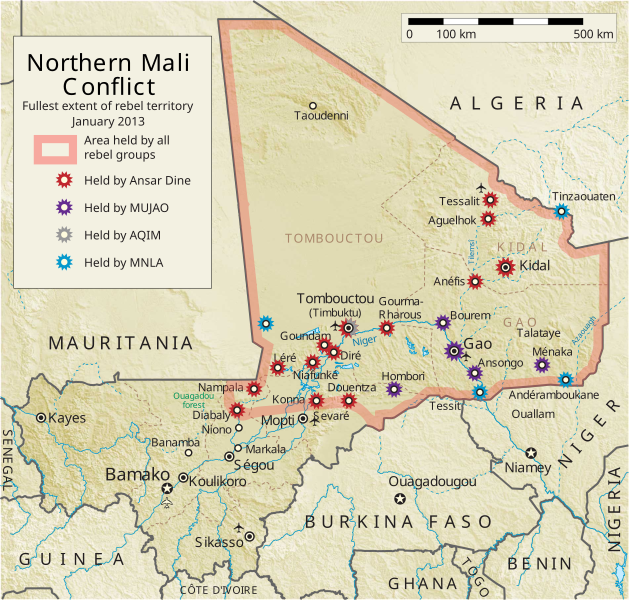
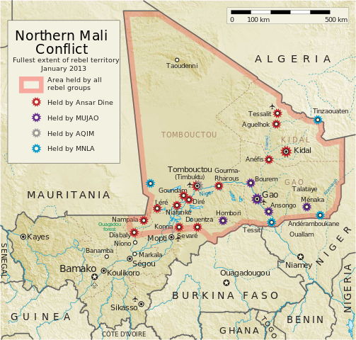
English: Map of the conflict in Northern Mali. (English)
العربية: خريطة الصّراع في شمال مالي. (إنجليزي)
Français : Carte du conflit au nord du Mali. (Anglais)
Latina: Charta rebellionis Tuaregorum in Malia septentrionali. (Anglice)
Українська: Карта конфлікту на півночі Малі. (Англійською) |
| 来源 |
自己的作品 |
| 作者 | Orionist |
| 其他版本 | German/Deutsch/Allemand, French/Français, Macedonian/македонски јазик/Macédonien |
| SVG开发 |
Notes
[编辑]
- ↑ US Department of State, "Country Reports on Terrorism 2011", Chapter 2 Country Reports: Africa Overview, 31 July 2012
许可协议
[编辑]
我,本作品著作权人,特此采用以下许可协议发表本作品:
本文件采用知识共享署名-相同方式共享 3.0 未本地化版本许可协议授权。
- 您可以自由地:
- 共享 – 复制、发行并传播本作品
- 修改 – 改编作品
- 惟须遵守下列条件:
- 署名 – 您必须对作品进行署名,提供授权条款的链接,并说明是否对原始内容进行了更改。您可以用任何合理的方式来署名,但不得以任何方式表明许可人认可您或您的使用。
- 相同方式共享 – 如果您再混合、转换或者基于本作品进行创作,您必须以与原先许可协议相同或相兼容的许可协议分发您贡献的作品。
文件历史
点击某个日期/时间查看对应时刻的文件。
| 日期/时间 | 缩略图 | 大小 | 用户 | 备注 | |
|---|---|---|---|---|---|
| 当前 | 2014年4月8日 (二) 06:59 | | 1,316 × 1,255(796 KB) | Ansh666(留言 | 贡献) | Reverted to version as of 16:51, 8 March 2013 - restoring the correct version, as the map is supposed to be historical, not current |
| 2013年12月5日 (四) 20:15 |  | 1,316 × 1,255(699 KB) | Hanibal911(留言 | 贡献) | more accurately reflects the situation | |
| 2013年3月8日 (五) 16:51 |  | 1,316 × 1,255(796 KB) | Agricolae(留言 | 贡献) | Hombori dot restored | |
| 2013年3月5日 (二) 14:29 |  | 1,316 × 1,255(794 KB) | TUFKAAP(留言 | 贡献) | Since this is an English map, Al-Qaeda in the Islamic Maghreb should be abbreviated as AQIM. | |
| 2013年2月11日 (一) 03:33 |  | 1,316 × 1,255(794 KB) | Agricolae(留言 | 贡献) | shift text distorted on upload | |
| 2013年2月11日 (一) 03:27 |  | 1,316 × 1,255(794 KB) | Agricolae(留言 | 贡献) | change to show greatest extent - see WP Talk:Northern Mali conflict (2012–present) | |
| 2013年2月8日 (五) 06:36 |  | 1,316 × 1,255(699 KB) | Rama(留言 | 贡献) | Aguelhok contested or taken ( http://www.lemonde.fr/afrique/article/2013/02/08/mali-les-forces-francaise-et-tchadiennes-a-aguelhok_1828906_3212.html ) | |
| 2013年2月2日 (六) 10:29 |  | 1,316 × 1,255(698 KB) | U5K0(留言 | 贡献) | Bourem to green as per talk page | |
| 2013年1月30日 (三) 08:41 |  | 1,316 × 1,255(679 KB) | Orionist(留言 | 贡献) | Updated map: Menaka, Anderamboukane, Ansongo, Dire, Kidal and other MNLA positions. Removed rebel area boundaries as the situation has become complicated. | |
| 2013年1月29日 (二) 17:23 |  | 1,316 × 1,255(894 KB) | Jaybear(留言 | 贡献) | Insertion of a map-scale in the upper right corner (added directly before the token "/svg" at end of svg-code); |
您不可以覆盖此文件。
文件用途
以下5个页面使用本文件:
全域文件用途
以下其他wiki使用此文件:
- af.wikipedia.org上的用途
- ar.wikipedia.org上的用途
- azb.wikipedia.org上的用途
- az.wikipedia.org上的用途
- bg.wikipedia.org上的用途
- bn.wikipedia.org上的用途
- ca.wikipedia.org上的用途
- cs.wikipedia.org上的用途
- cy.wikipedia.org上的用途
- da.wikipedia.org上的用途
- de.wikipedia.org上的用途
- el.wikipedia.org上的用途
- en.wikipedia.org上的用途
- Mali
- Portal:Mali
- Insurgency in the Maghreb (2002–present)
- War on terror
- User:Orionist/Gallery
- National Movement for the Liberation of Azawad
- Wikipedia talk:WikiProject Maps/Archive 2012
- Wikipedia:In the news/Candidates/April 2012
- Wikipedia:Graphics Lab/Map workshop/Archive/Apr 2012
- Wikipedia:Wikipedia Signpost/2012-04-30/WikiProject report
- Wikipedia:Wikipedia Signpost/Single/2012-04-30
- Mali War
- Wikipedia:WikiProject Maps/Conventions/Pushpin maps
- Operation Serval
- Chadian intervention in northern Mali
- Islamist insurgency in the Sahel
- User:AlbanianEditor1990/sandbox
- en.wikinews.org上的用途
- eo.wikipedia.org上的用途
- es.wikipedia.org上的用途
- et.wikipedia.org上的用途
- eu.wikipedia.org上的用途
- fi.wikipedia.org上的用途
查看此文件的更多全域用途。