File:Norway counties.svg
跳至導覽
跳至搜尋

此 SVG 檔案的 PNG 預覽的大小:514 × 550 像素。 其他解析度:224 × 240 像素 | 449 × 480 像素 | 718 × 768 像素 | 957 × 1,024 像素 | 1,914 × 2,048 像素。
原始檔案 (SVG 檔案,表面大小:514 × 550 像素,檔案大小:579 KB)
說明
說明
添加單行說明來描述出檔案所代表的內容
| 描述 |
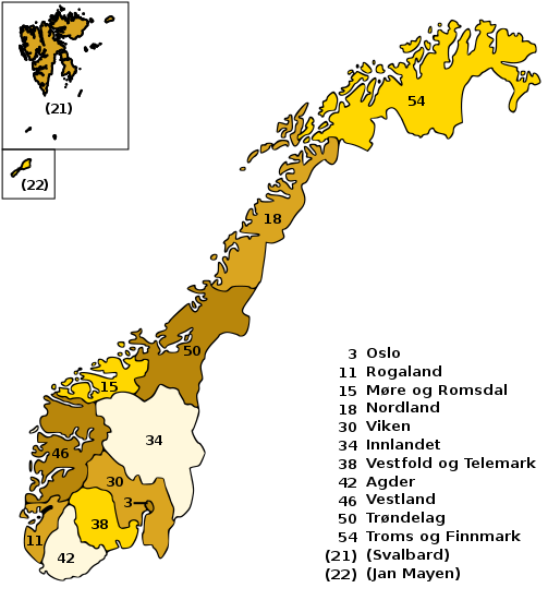
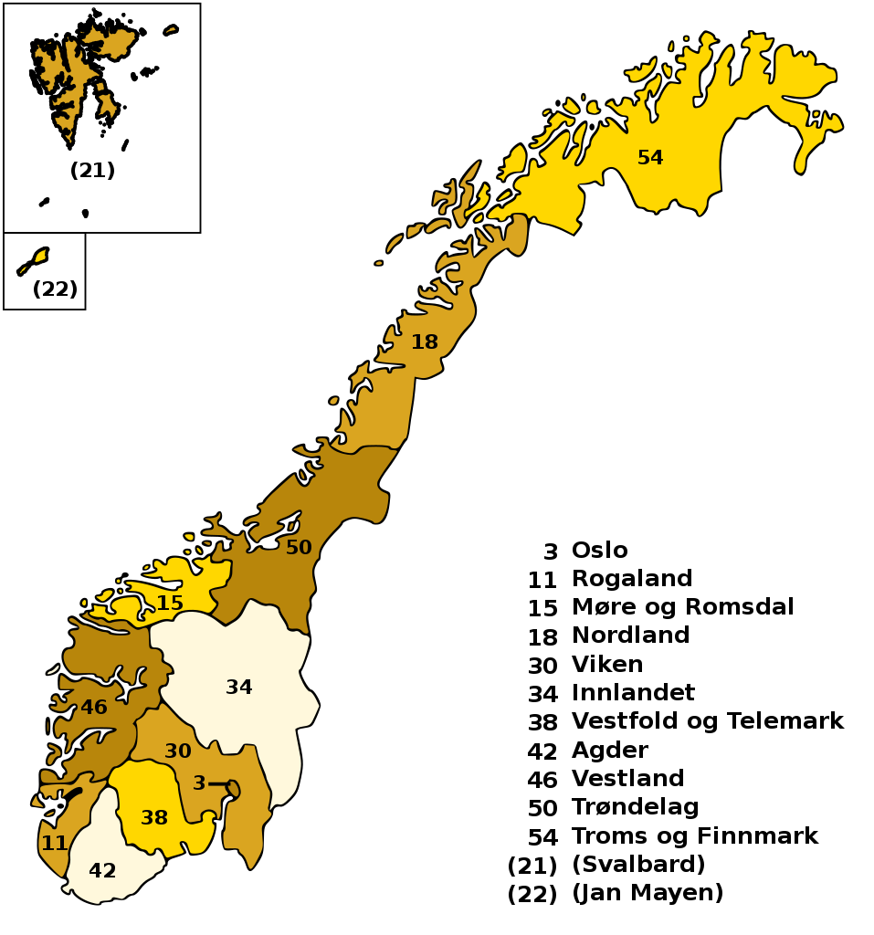
English: Counties of Norway, with ISO 3166-2:NO code and legend. SVG format. |
| 日期 | (updated 2021-03-02) |
| 來源 | SVG created using Image:Norway counties.jpg (by Eddideigel) and Image:Norge kort numerowana.png (by Voyager) |
| 作者 | Júlio Reis and João David Tereso |
| 授權許可 (重用此檔案) |
I, the author release this image under Creative Commons Attribution ShareAlike. |
| 其他版本 |
Derivative works of this file:
|

.svg)
.svg)
此檔案採用創用CC 姓名標示-相同方式分享 2.5 通用版授權條款。
- 您可以自由:
- 分享 – 複製、發佈和傳播本作品
- 重新修改 – 創作演繹作品
- 惟需遵照下列條件:
- 姓名標示 – 您必須指名出正確的製作者,和提供授權條款的連結,以及表示是否有對內容上做出變更。您可以用任何合理的方式來行動,但不得以任何方式表明授權條款是對您許可或是由您所使用。
- 相同方式分享 – 如果您利用本素材進行再混合、轉換或創作,您必須基於如同原先的相同或兼容的條款,來分布您的貢獻成品。
This image was selected as picture of the day on Wikimedia Commons for 21 November 2005. It was captioned as follows: English: Counties of Norway Other languages:
Cymraeg: Siroedd Norwy Deutsch: Verwaltungsprovinzen von Norwegen English: Counties of Norway Español: Condados de Noruega Français : Les comtés (fylker) de Norvège Gaeilge: Contaetha na hIorua Galego: Fylker (condados) de Noruega. Italiano: Le contee della Norvegia Latina: Comitatus Norvegici Nederlands: Counties van Noorwegen Norsk bokmål: Norske fylker Norsk nynorsk: Norske fylke. Polski: Regiony Norwegii Português: Condados da Noruega Slovenčina: Nórske regióny Slovenščina: Norveške province Suomi: Norjan kunnat Русский: Графства Норвегии ไทย: จังหวัดต่าง ๆ ของประเทศนอร์เวย์ 日本語: ノルウェーの州区分図 中文: 挪威分县地图 עברית : מחוזות נורבגיה |
檔案歷史
點選日期/時間以檢視該時間的檔案版本。
| 日期/時間 | 縮圖 | 尺寸 | 用戶 | 備註 | |
|---|---|---|---|---|---|
| 目前 | 2021年3月2日 (二) 10:11 | | 514 × 550(579 KB) | Jon Harald Søby(對話 | 貢獻) | update merged counties, add Jan Mayen |
| 2019年4月10日 (三) 08:16 |  | 514 × 550(572 KB) | Andreyyshore(對話 | 貢獻) | Trøndelag was changed from NO-23 to NO-50 | |
| 2018年12月3日 (一) 09:38 |  | 514 × 550(572 KB) | Herzi Pinki(對話 | 貢獻) | Sør-Trøndelag and Nord-Trøndelag have been merged to Trøndelag with Nr. 23 on 1st Jan. 2018 | |
| 2018年7月12日 (四) 21:19 |  | 514 × 550(576 KB) | Jmv(對話 | 貢獻) | Reverted to version as of 13:52, 22 October 2009 (UTC), there is still no ISO 3166-2:NO-50 definition | |
| 2018年1月2日 (二) 13:53 |  | 514 × 550(572 KB) | Jon Harald Søby(對話 | 貢獻) | Update, Sør-Trøndelag and Nord-Trøndelag merged on Jan 1 | |
| 2009年10月22日 (四) 13:52 |  | 514 × 550(576 KB) | Janbrogger(對話 | 貢獻) | Sorry, still having text trouble. | |
| 2009年10月22日 (四) 13:51 |  | 514 × 550(575 KB) | Janbrogger(對話 | 貢獻) | Text trouble, adding Svalbard... Looks OK in my program here. | |
| 2009年10月22日 (四) 13:46 |  | 514 × 550(578 KB) | Janbrogger(對話 | 貢獻) | Uploading again, trying to add Svalbard | |
| 2009年10月22日 (四) 13:45 |  | 514 × 550(578 KB) | Janbrogger(對話 | 貢獻) | Added Svalbard | |
| 2005年10月5日 (三) 16:11 |  | 514 × 550(161 KB) | Tintazul(對話 | 貢獻) | {{Information| |Description=Counties of Norway, with ISO 3166-2:NO code and legend. SVG format. |Source=SVG created using Image:Norway counties.jpg and Image:Norge kort numerowana.png |Date=05 October 2005 |Author=Júlio Reis (User:Tintazul) |
無法覆蓋此檔案。
檔案用途
下列41個頁面有用到此檔案:
- Atlas of Norway
- Maps of Norway
- Norge
- Talk:Atlas of Norway
- User:STyx/Project Mapmaking Wiki Standards
- User:Tereso~commonswiki/gallery
- User:Tintazul/Maps and places
- Commons:Potd/2005-11 (fr)
- Commons:Potd/2005-11 (pl)
- Commons:Potd/2005-11 (pt)
- Commons:Potd/2005-11 (ru)
- Commons:Potd/2005-11 (sv)
- Commons:Potd/2005-11 (tr)
- File:Norway counties mk.svg
- File:Norwegen-Referendum 1972.svg
- File:Norwegen-Referendum 1994.svg
- File:Norwegen-Referendum 1994 Anteile.png
- Template:Potd/2005-11
- Template:Potd/2005-11-21
- Template:Potd/2005-11-21 (cy)
- Template:Potd/2005-11-21 (de)
- Template:Potd/2005-11-21 (en)
- Template:Potd/2005-11-21 (es)
- Template:Potd/2005-11-21 (fi)
- Template:Potd/2005-11-21 (fr)
- Template:Potd/2005-11-21 (ga)
- Template:Potd/2005-11-21 (gl)
- Template:Potd/2005-11-21 (he)
- Template:Potd/2005-11-21 (it)
- Template:Potd/2005-11-21 (ja)
- Template:Potd/2005-11-21 (la)
- Template:Potd/2005-11-21 (nb)
- Template:Potd/2005-11-21 (nl)
- Template:Potd/2005-11-21 (nn)
- Template:Potd/2005-11-21 (pl)
- Template:Potd/2005-11-21 (pt)
- Template:Potd/2005-11-21 (ru)
- Template:Potd/2005-11-21 (sk)
- Template:Potd/2005-11-21 (sl)
- Template:Potd/2005-11-21 (th)
- Template:Potd/2005-11-21 (zh-hans)
全域檔案使用狀況
以下其他 wiki 使用了這個檔案:
- ar.wikipedia.org 的使用狀況
- ast.wikipedia.org 的使用狀況
- azb.wikipedia.org 的使用狀況
- bpy.wikipedia.org 的使用狀況
- ca.wikipedia.org 的使用狀況
- de.wikipedia.org 的使用狀況
- en.wikipedia.org 的使用狀況
- eo.wikipedia.org 的使用狀況
- es.wikibooks.org 的使用狀況
- fa.wikipedia.org 的使用狀況
- fi.wikipedia.org 的使用狀況
- fr.wikipedia.org 的使用狀況
- fy.wikipedia.org 的使用狀況
- he.wikipedia.org 的使用狀況
- hu.wikipedia.org 的使用狀況
- ia.wikipedia.org 的使用狀況
- incubator.wikimedia.org 的使用狀況
- is.wikipedia.org 的使用狀況
- it.wikiversity.org 的使用狀況
- ja.wikipedia.org 的使用狀況
- ko.wikipedia.org 的使用狀況
- lv.wikipedia.org 的使用狀況
- nds.wikipedia.org 的使用狀況
- nn.wikipedia.org 的使用狀況
- no.wikipedia.org 的使用狀況
- os.wikipedia.org 的使用狀況
- pl.wikipedia.org 的使用狀況
- pl.wikinews.org 的使用狀況
- pnb.wikipedia.org 的使用狀況
- ps.wikivoyage.org 的使用狀況
- ro.wikipedia.org 的使用狀況
檢視此檔案的更多全域使用狀況。