File:Nottinghamshire UK locator map 2010.svg
Ir a la navegación
Ir a la búsqueda

Tamaño de esta previsualización PNG del archivo SVG: 494 × 600 píxeles. Otras resoluciones: 198 × 240 píxeles | 395 × 480 píxeles | 633 × 768 píxeles | 843 × 1024 píxeles | 1687 × 2048 píxeles | 1108 × 1345 píxeles.
Archivo original (archivo SVG, nominalmente 1108 × 1345 píxeles, tamaño de archivo: 302 kB)
Leyendas
Leyendas
Añade una explicación corta acerca de lo que representa este archivo
Resumen
[editar]
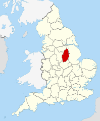
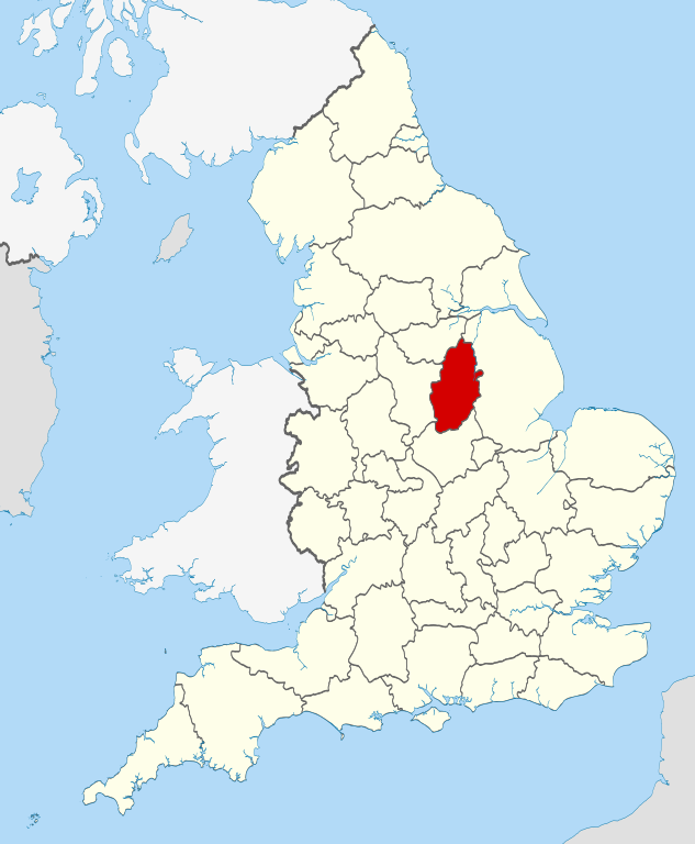
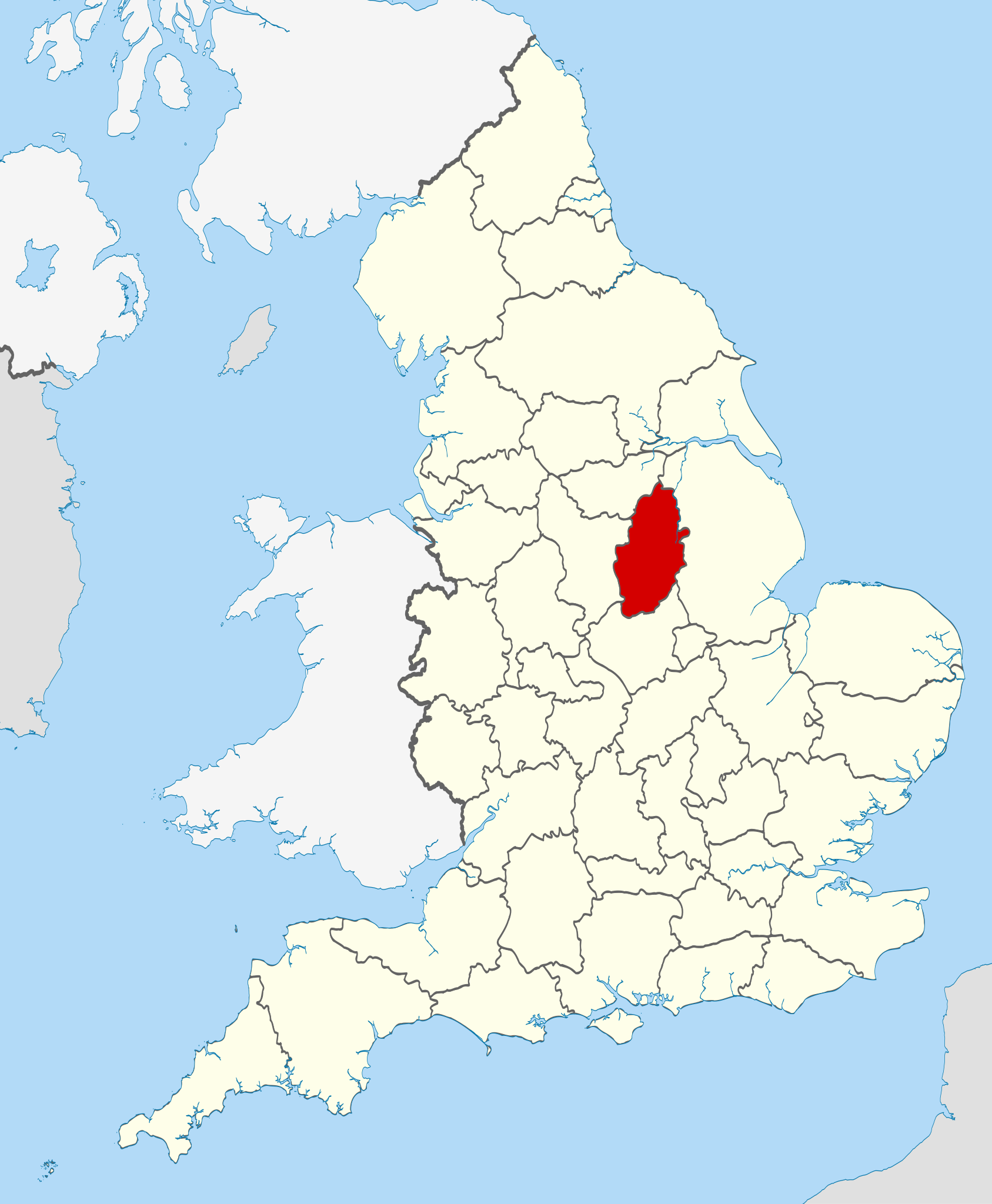
| Descripción | Location of the ceremonial county of Nottinghamshire within England. |
| Fecha | |
| Fuente |
National Geospatial-Intelligence Agency
|
| Autor | Nilfanion |
Licencia
[editar]
Yo, titular de los derechos de autor de esta obra, la publico en los términos de las siguientes licencias:
Este archivo se encuentra bajo la licencia Creative Commons Genérica de Atribución/Compartir-Igual 3.0.
- Eres libre:
- de compartir – de copiar, distribuir y transmitir el trabajo
- de remezclar – de adaptar el trabajo
- Bajo las siguientes condiciones:
- atribución – Debes otorgar el crédito correspondiente, proporcionar un enlace a la licencia e indicar si realizaste algún cambio. Puedes hacerlo de cualquier manera razonable pero no de manera que sugiera que el licenciante te respalda a ti o al uso que hagas del trabajo.
- compartir igual – En caso de mezclar, transformar o modificar este trabajo, deberás distribuir el trabajo resultante bajo la misma licencia o una compatible como el original.

|
Se autoriza la copia, distribución y modificación de este documento bajo los términos de la licencia de documentación libre GNU, versión 1.2 o cualquier otra que posteriormente publique la Fundación para el Software Libre; sin secciones invariables, textos de portada, ni textos de contraportada. Se incluye una copia de la dicha licencia en la sección titulada Licencia de Documentación Libre GNU. |
Puedes usar la licencia que prefieras.

|
This is one of the images forming part of the Valued image set: Locator maps of the Ceremonial counties of England on Wikimedia Commons. The image set has been assessed under the valued image set criteria and is considered the most valued set on Commons within the scope:
Locator maps of the Ceremonial counties of England
You can see its nomination at Commons:Valued image candidates/Locator maps of English ceremonial counties. |
Historial del archivo
Haz clic sobre una fecha y hora para ver el archivo tal como apareció en ese momento.
| Fecha y hora | Miniatura | Dimensiones | Usuario | Comentario | |
|---|---|---|---|---|---|
| actual | 22:42 23 nov 2010 | | 1108 × 1345 (302 kB) | Nilfanion (discusión | contribs.) | == Summary == {{Information |Description=Location of the ceremonial county of Nottinghamshire within England. |Source=Ordnance Survey [https://www.ordnancesurvey.co.uk/opendatadownload/products.html OpenData]: * |
No puedes sobrescribir este archivo.
Usos del archivo
Las siguientes páginas usan este archivo:
- Valued image set: Locator maps of the Ceremonial counties of England
- Commons:Valued image candidates/Locator maps of English ceremonial counties
- Category:Almshouses in Nottinghamshire
- Category:Alumni by school in Nottinghamshire
- Category:Births in Nottinghamshire
- Category:Bridges in Nottinghamshire
- Category:Broach spires in Nottinghamshire
- Category:Bus stations in Nottinghamshire
- Category:Canals in Nottinghamshire
- Category:Deaths in Nottinghamshire
- Category:Events in Nottinghamshire
- Category:Hospitals in Nottinghamshire
- Category:Maps of Nottinghamshire
- Category:Mines in Nottinghamshire
- Category:Nottinghamshire
- Category:Nottinghamshire in the 1970s
- Category:Nottinghamshire in the 1980s
- Category:Nottinghamshire in the 1990s
- Category:Nottinghamshire in the 19th century
- Category:Nottinghamshire in the 2000s
- Category:Nottinghamshire in the 20th century
- Category:Nottinghamshire in the 21st century
- Category:People of Nottinghamshire
- Category:Police stations in Nottinghamshire
- Category:Populated places in Nottinghamshire
- Category:Rail transport in Nottinghamshire
- Category:Rivers of Nottinghamshire
- Category:Tunnels in Nottinghamshire
- Category:Views of Nottinghamshire
- Category:Villages in Nottinghamshire
- Category:Visitor attractions in Nottinghamshire
- Category:Windmills in Nottinghamshire
Uso global del archivo
Las wikis siguientes utilizan este archivo:
- Uso en af.wikipedia.org
- Uso en ar.wikipedia.org
- Uso en arz.wikipedia.org
- Uso en ast.wikipedia.org
- Uso en be-tarask.wikipedia.org
- Uso en be.wikipedia.org
- Uso en bg.wikipedia.org
- Uso en br.wikipedia.org
- Uso en bs.wikipedia.org
- Uso en ca.wikipedia.org
- Uso en ceb.wikipedia.org
- Uso en cs.wikipedia.org
- Uso en dag.wikipedia.org
- Uso en da.wikipedia.org
- Uso en de.wikipedia.org
- Uso en en.wikipedia.org
- Nottinghamshire
- University Farm (Nottinghamshire)
- Bircotes
- Manton, Nottinghamshire
- Soar Valley
- Redhill, Nottinghamshire
- Spion Kop, Nottinghamshire
- Ratcliffe-on-Soar
- Bunny, Nottinghamshire
- North Leverton with Habblesthorpe
- List of parliamentary constituencies in Nottinghamshire
- Adbolton
- Barton in Fabis
- Trent Lock
- Template:Nottinghamshire-geo-stub
- Wilford Hill
- Rhodesia, Nottinghamshire
- Meering
- Annesley
- Askham, Nottinghamshire
- Awsworth
- Barnby in the Willows
- Bathley
- Beckingham, Nottinghamshire
- Bestwood St. Albans
- Bevercotes
- Kneeton
- Beeston and Stapleford Urban District
- Bothamsall
- Bulcote
- Worksop Rural District
- Butler's Hill
Ver más uso global de este archivo.