File:Nottinghamshire UK locator map 2010.svg
Pāriet uz navigāciju
Pāriet uz meklēšanu

Size of this PNG preview of this SVG file: 494 × 600 pikseļi. Citi izmēri: 198 × 240 pikseļi | 395 × 480 pikseļi | 633 × 768 pikseļi | 843 × 1 024 pikseļi | 1 687 × 2 048 pikseļi | 1 108 × 1 345 pikseļi.
Sākotnējais fails (SVG fails, definētais izmērs 1 108 × 1 345 pikseļi, faila izmērs: 302 KB)
Captions
Captions
Pievieno vienas rindiņas aprakstu, ko šis fails attēlo
Kopsavilkums[labot šo sadaļu]
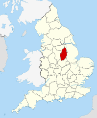
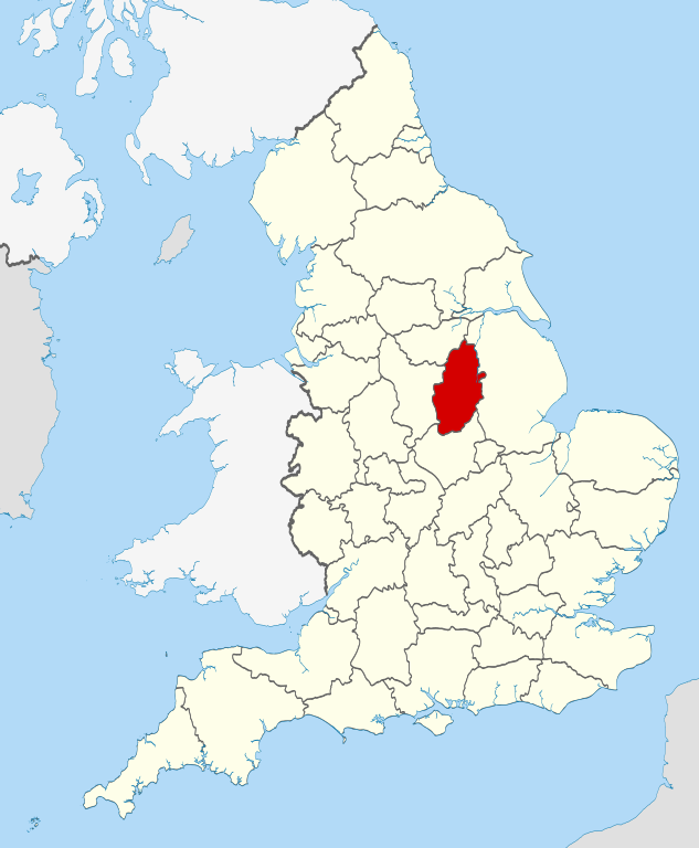
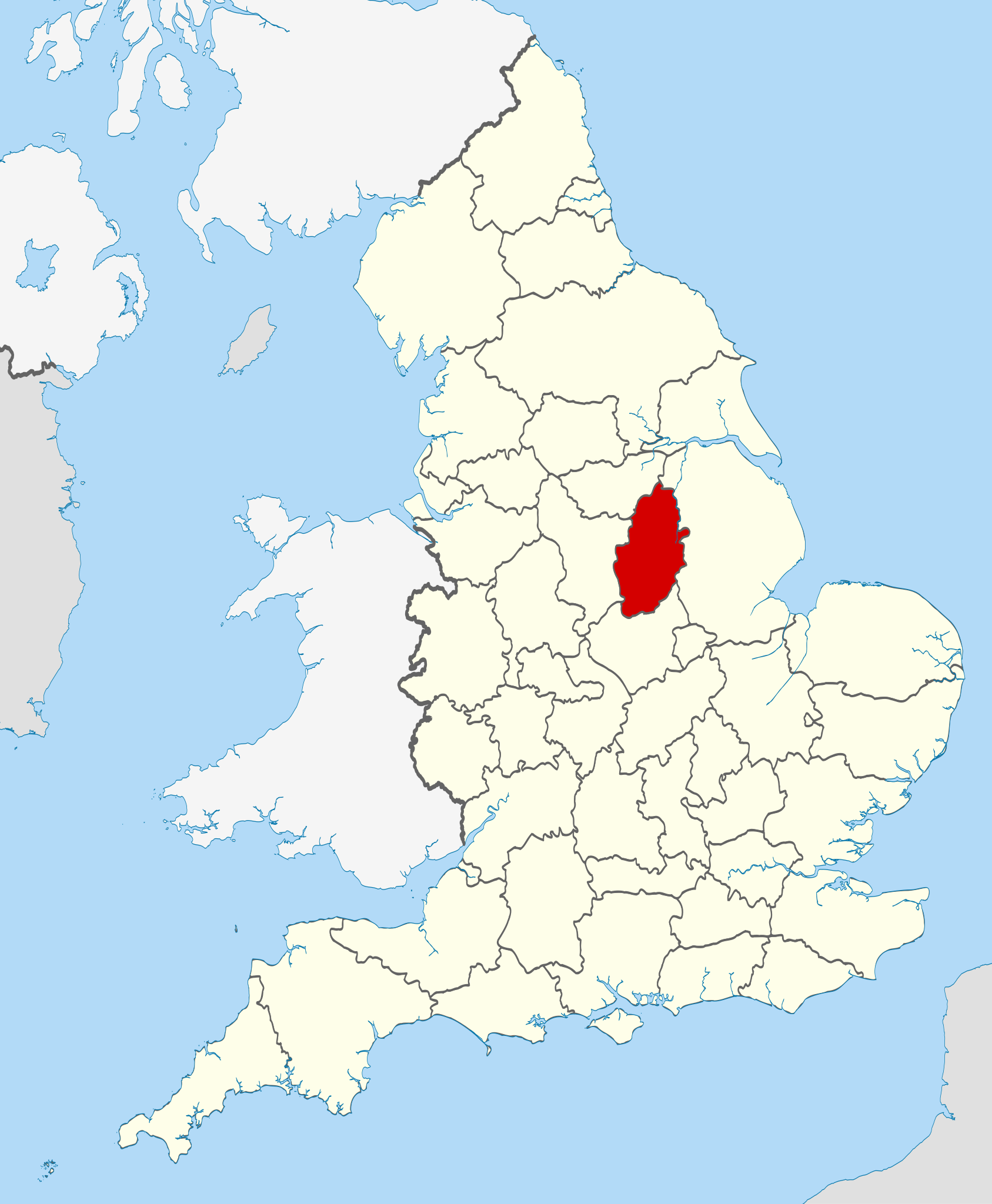
| Apraksts | Location of the ceremonial county of Nottinghamshire within England. |
| Datums | |
| Avots |
National Geospatial-Intelligence Agency
|
| Autors | Nilfanion |
Licence[labot šo sadaļu]
Es, šī darba autortiesību īpašnieks, publicēju to saskaņā ar šīm licencēm:
Šis fails tiek izplatīts saskaņā ar licences Creative Commons Atsauce-Līdzīgi Noteikumi 3.0 Vispārējiem noteikumiem.
- Jūs varat brīvi:
- koplietot – kopēt, izplatīt un pārraidīt darbu
- remiksēt – pielāgot darbu
- Saskaņā ar šādiem nosacījumiem:
- atsaucoties – Tev ir jānorāda autors, saite uz licenci un to, vai veiktas kādas izmaiņas. To var darīt jebkādā saprātīgā veidā, bet ne tādā, kas norādītu, ka licencētājs atbalsta tevi vai veidu, kā tu izmanto šo darbu.
- nemainot licenci – Ja tu miksē, pārveido vai izmanto materiālu, tev savs devums jāpublicē ar to pašu vai saderīgu licenci kā oriģināls.

|
Ir dota atļauja kopēt, izplatīt un/vai pārveidot šo dokumentu saskaņā ar GNU brīvās dokumentācijas licences, versijas 1.2 vai jebkuras vēlākas versijas, ko publiskojis Brīvās programmatūras fonds nosacījumiem; bez nemainīgajām sadaļā, priekšējā un aizmugurēja'vāka tekstiem. Licences kopija ir iekļauta sadaļā ar nosaukumu GNU brīvās dokumentācijas licence. |
Jūs varat izvēlēties licenci pēc jūsu vēlmes.

|
This is one of the images forming part of the Valued image set: Locator maps of the Ceremonial counties of England on Wikimedia Commons. The image set has been assessed under the valued image set criteria and is considered the most valued set on Commons within the scope:
Locator maps of the Ceremonial counties of England
You can see its nomination at Commons:Valued image candidates/Locator maps of English ceremonial counties. |
Faila hronoloģija
Uzklikšķini uz datums/laiks kolonnā esošās saites, lai apskatītos, kā šis fails izskatījās tad.
| Datums/Laiks | Attēls | Izmēri | Dalībnieks | Komentārs | |
|---|---|---|---|---|---|
| tagadējais | 2010. gada 23. novembris, plkst. 22.42 | | 1 108 × 1 345 (302 KB) | Nilfanion (diskusija | devums) | == Summary == {{Information |Description=Location of the ceremonial county of Nottinghamshire within England. |Source=Ordnance Survey [https://www.ordnancesurvey.co.uk/opendatadownload/products.html OpenData]: * |
Šo failu nevar pārrakstīt.
Faila lietojums
Šo failu izmanto šajās 32 lapās:
- Valued image set: Locator maps of the Ceremonial counties of England
- Commons:Valued image candidates/Locator maps of English ceremonial counties
- Category:Almshouses in Nottinghamshire
- Category:Alumni by school in Nottinghamshire
- Category:Births in Nottinghamshire
- Category:Bridges in Nottinghamshire
- Category:Broach spires in Nottinghamshire
- Category:Bus stations in Nottinghamshire
- Category:Canals in Nottinghamshire
- Category:Deaths in Nottinghamshire
- Category:Events in Nottinghamshire
- Category:Hospitals in Nottinghamshire
- Category:Maps of Nottinghamshire
- Category:Mines in Nottinghamshire
- Category:Nottinghamshire
- Category:Nottinghamshire in the 1970s
- Category:Nottinghamshire in the 1980s
- Category:Nottinghamshire in the 1990s
- Category:Nottinghamshire in the 19th century
- Category:Nottinghamshire in the 2000s
- Category:Nottinghamshire in the 20th century
- Category:Nottinghamshire in the 21st century
- Category:People of Nottinghamshire
- Category:Police stations in Nottinghamshire
- Category:Populated places in Nottinghamshire
- Category:Rail transport in Nottinghamshire
- Category:Rivers of Nottinghamshire
- Category:Tunnels in Nottinghamshire
- Category:Views of Nottinghamshire
- Category:Villages in Nottinghamshire
- Category:Visitor attractions in Nottinghamshire
- Category:Windmills in Nottinghamshire
Globālais faila lietojums
Šīs Vikipēdijas izmanto šo failu:
- Izmantojums af.wikipedia.org
- Izmantojums ar.wikipedia.org
- Izmantojums arz.wikipedia.org
- Izmantojums ast.wikipedia.org
- Izmantojums be-tarask.wikipedia.org
- Izmantojums be.wikipedia.org
- Izmantojums bg.wikipedia.org
- Izmantojums br.wikipedia.org
- Izmantojums bs.wikipedia.org
- Izmantojums ca.wikipedia.org
- Izmantojums ceb.wikipedia.org
- Izmantojums cs.wikipedia.org
- Izmantojums dag.wikipedia.org
- Izmantojums da.wikipedia.org
- Izmantojums de.wikipedia.org
- Izmantojums en.wikipedia.org
- Nottinghamshire
- University Farm (Nottinghamshire)
- Bircotes
- Manton, Nottinghamshire
- Soar Valley
- Redhill, Nottinghamshire
- Spion Kop, Nottinghamshire
- Ratcliffe-on-Soar
- Bunny, Nottinghamshire
- North Leverton with Habblesthorpe
- Adbolton
- Barton in Fabis
- Trent Lock
- Template:Nottinghamshire-geo-stub
- Wilford Hill
- Rhodesia, Nottinghamshire
- Meering
- Annesley
- Askham, Nottinghamshire
- Awsworth
- Barnby in the Willows
- Bathley
- Beckingham, Nottinghamshire
- Bestwood St. Albans
- Bevercotes
- Kneeton
- Beeston and Stapleford Urban District
- Bothamsall
- Bulcote
- Worksop Rural District
- Butler's Hill
- Westville, Nottinghamshire
Skatīt šī faila pilno globālo izmantojumu.