File:Nya Sverige.svg
跳至導覽
跳至搜尋

此 SVG 檔案的 PNG 預覽的大小:342 × 599 像素。 其他解析度:137 × 240 像素 | 274 × 480 像素 | 439 × 768 像素 | 585 × 1,024 像素 | 1,170 × 2,048 像素 | 720 × 1,260 像素。
原始檔案 (SVG 檔案,表面大小:720 × 1,260 像素,檔案大小:461 KB)
說明
說明
添加單行說明來描述出檔案所代表的內容
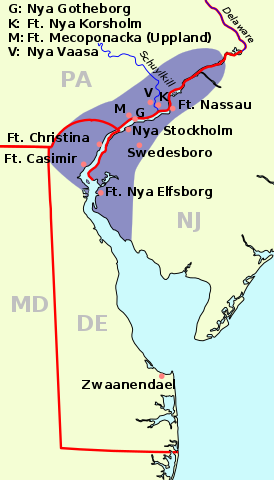
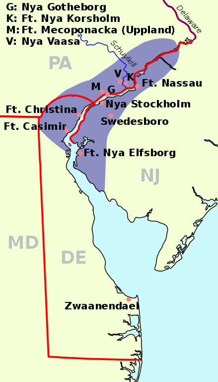
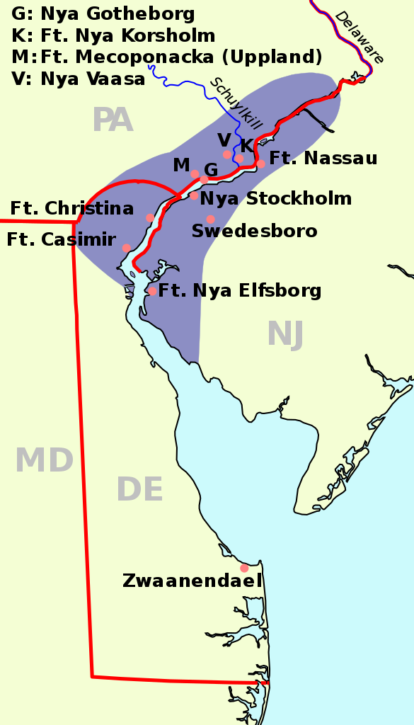
Map of New Sweden, 1638
摘要[編輯]
| 描述 |
English: The map of New Sweden, 1638 Deutsch: Karte von Neu-Schweden, 1638. Русский: Карта Новой Швеции, 1638 год Svenska: Karta över Nya Sverige, 1638 |
| 日期 | (UTC) |
| 來源 | |
| 作者 |
|
| SVG開發 |
| See also: Nieuw Nederland and Nya Sverige |
此檔案採用創用CC 姓名標示-相同方式分享 3.0 未在地化版本授權條款。
- 您可以自由:
- 分享 – 複製、發佈和傳播本作品
- 重新修改 – 創作演繹作品
- 惟需遵照下列條件:
- 姓名標示 – 您必須指名出正確的製作者,和提供授權條款的連結,以及表示是否有對內容上做出變更。您可以用任何合理的方式來行動,但不得以任何方式表明授權條款是對您許可或是由您所使用。
- 相同方式分享 – 如果您利用本素材進行再混合、轉換或創作,您必須基於如同原先的相同或兼容的條款,來分布您的貢獻成品。
原始上傳日誌[編輯]
This image is a derivative work of the following images:
- File:Nya Sverige.png licensed with Cc-by-sa-3.0-migrated, GFDL, PD-self
- 2005-10-12T00:50:54Z Arnapha 306x528 (6492 Bytes) Map of New-Sweden ca. 1650 Created on base of the maps of Delaware and New Jersey from the Perry Castañeda Library (at http://www.lib.utexas.edu/maps/united_states.html). Transferred from German Wikipedia (http://de.wikipe
- File:USA New Jersey location map.svg licensed with Cc-by-3.0, GFDL
- 2009-06-17T19:59:27Z Alexrk2 839x1560 (259806 Bytes) enh
- 2009-06-13T18:01:16Z Alexrk 839x1560 (198653 Bytes) fixed SVG bug
- 2009-06-13T17:46:17Z Alexrk 839x1560 (246056 Bytes) == Beschreibung == {{Information |Description= {{de|Positionskarte von [[:de:New Jersey|New Jersey]], [[:de:USA|USA]]}} Quadratische Plattkarte, N-S-Streckung 130.0 %. Geographische Begrenzung der Karte: * N: 41.6° N * S: 38
- File:USA New York location map.svg licensed with Cc-by-3.0, GFDL
- 2009-06-10T11:28:20Z NordNordWest 1572x1277 (597043 Bytes) {{Information |Description= {{de|Positionskarte vom Bundesstaat [[:de:New York (Bundesstaat)|New York]], [[:de:USA|USA]]}} Quadratische Plattkarte, N-S-Streckung 135 %. Geographische Begrenzung der Karte: * N: 45.3° N * S: 4
- File:USA Delaware location map.svg licensed with Cc-by-3.0, GFDL
- 2009-06-22T10:54:18Z Alexrk2 470x800 (106507 Bytes) renderer bug
- 2009-06-22T10:39:54Z Alexrk2 470x800 (66078 Bytes) == Beschreibung == {{Information |Description= {{de|Positionskarte von [[:de:Delaware|Delaware]], [[:de:USA|USA]]}} Quadratische Plattkarte, N-S-Streckung 130.0 %. Geographische Begrenzung der Karte: * N: 40.0° N * S: 38.3°
Uploaded with derivativeFX
檔案歷史
點選日期/時間以檢視該時間的檔案版本。
| 日期/時間 | 縮圖 | 尺寸 | 使用者 | 備註 | |
|---|---|---|---|---|---|
| 目前 | 2011年1月1日 (六) 08:23 | | 720 × 1,260(461 KB) | Arnapha(留言 | 貢獻) | adapted size |
| 2011年1月1日 (六) 06:05 |  | 730 × 1,270(461 KB) | Arnapha(留言 | 貢獻) | moved origin | |
| 2011年1月1日 (六) 06:01 |  | 730 × 1,270(461 KB) | Arnapha(留言 | 貢獻) | use total viewBox | |
| 2011年1月1日 (六) 05:12 |  | 1,020 × 1,760(461 KB) | Arnapha(留言 | 貢獻) | text position | |
| 2011年1月1日 (六) 04:18 |  | 1,020 × 1,760(461 KB) | Arnapha(留言 | 貢獻) | removed unused items | |
| 2011年1月1日 (六) 02:26 |  | 1,020 × 1,760(644 KB) | Arnapha(留言 | 貢獻) | {{Information |Description={{en|The map of New Sweden, 1638. Created on base of the maps of Delaware and New Jersey from the Perry Castañeda Library (at [http://www.lib.utexas.edu/maps/united_states.html www.lib.utexas.edu]).}} {{de|Karte von Neu-Schwede |
無法覆蓋此檔案。
檔案用途
下列4個頁面有用到此檔案:
全域檔案使用狀況
以下其他 wiki 使用了這個檔案:
- af.wikipedia.org 的使用狀況
- azb.wikipedia.org 的使用狀況
- be.wikipedia.org 的使用狀況
- bg.wikipedia.org 的使用狀況
- bs.wikipedia.org 的使用狀況
- ca.wikipedia.org 的使用狀況
- cs.wikipedia.org 的使用狀況
- da.wikipedia.org 的使用狀況
- de.wikipedia.org 的使用狀況
- en.wikipedia.org 的使用狀況
- es.wikipedia.org 的使用狀況
- fi.wikipedia.org 的使用狀況
- fr.wikipedia.org 的使用狀況
- fy.wikipedia.org 的使用狀況
- he.wikipedia.org 的使用狀況
- hr.wikipedia.org 的使用狀況
- hu.wikipedia.org 的使用狀況
- io.wikipedia.org 的使用狀況
- it.wikipedia.org 的使用狀況
- li.wikipedia.org 的使用狀況
- nds.wikipedia.org 的使用狀況
- nl.wikipedia.org 的使用狀況
- nn.wikipedia.org 的使用狀況
- no.wikipedia.org 的使用狀況
- pl.wikipedia.org 的使用狀況
- pt.wikipedia.org 的使用狀況
- ru.wikipedia.org 的使用狀況
- sh.wikipedia.org 的使用狀況
檢視此檔案的更多全域使用狀況。
詮釋資料
分類:
- SVG maps of New Jersey
- Maps of New Sweden
- SVG maps of Delaware
- SVG maps of Pennsylvania
- Swedish-language SVG maps showing history
- Maps of the Swedish Empire (1561-1721)
- 1630s maps of New Jersey
- 1630s maps of Pennsylvania
- 1630s maps of Delaware
- Fort Casimir
- Fort Christina
- Fort Nya Elfsborg
- Swedesboro, New Jersey
- Fort Nassau (South River)
- Zwaanendael
- 1638 maps of North America
- Maps of the history of Delaware
- Maps of the history of Pennsylvania
- Maps of the history of New Jersey