File:OHMap-doton-Loveland.png
跳至導覽
跳至搜尋
無更高解析度可提供。
OHMap-doton-Loveland.png (274 × 300 像素,檔案大小:10 KB,MIME 類型:image/png)
說明
說明
添加單行說明來描述出檔案所代表的內容
摘要[編輯]
| 描述 | |
| 日期 | 2004年七月19日 (原始上傳日期) |
| 來源 |
Adapted from Wikipedia's OH county maps by Catbar. abr/> Transferred from en.wikipedia. |
| 作者 | Catbar at en.wikipedia |
授權條款[編輯]
Catbar at en.wikipedia,此作品的版權所有人,決定用以下授權條款發佈本作品:

|
已授權您依據自由軟體基金會發行的無固定段落、封面文字和封底文字GNU自由文件授權條款1.2版或任意後續版本,對本檔進行複製、傳播和/或修改。該協議的副本列在GNU自由文件授權條款中。 |
| 此檔案採用共享創意 姓名標示-相同方式分享 3.0 未在地化版本授權條款。 | ||
| 姓名標示: Catbar at en.wikipedia | ||
| ||
| 已新增授權條款標題至此檔案,作為GFDL授權更新的一部份。 |
原始上傳日誌[編輯]
The original description page was here. All following user names refer to en.wikipedia.
- 2004-07-19 22:24 Catbar 274×300× (10438 bytes) {{msg:GFDL}}<br>Adapted from Wikipedia's OH county maps by Catbar.
檔案歷史
點選日期/時間以檢視該時間的檔案版本。
| 日期/時間 | 縮圖 | 尺寸 | 用戶 | 備註 | |
|---|---|---|---|---|---|
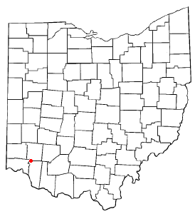
| 目前 | 2006年1月30日 (一) 11:22 | | 274 × 300(10 KB) | Mxn(對話 | 貢獻) | County map of Ohio, with a red dot at '''Loveland, Ohio''', which is located in three counties. Adapted from Wikipedia's OH county maps by Catbar. {{GFDL-user|Catbar|en}} Category:Maps of Ohio |
無法覆蓋此檔案。
檔案用途
下列頁面有用到此檔案:
全域檔案使用狀況
以下其他 wiki 使用了這個檔案:
- ca.wikipedia.org 的使用狀況
- en.wikipedia.org 的使用狀況
- fr.wikipedia.org 的使用狀況
- ht.wikipedia.org 的使用狀況
- id.wikipedia.org 的使用狀況
- it.wikipedia.org 的使用狀況
- ja.wikipedia.org 的使用狀況
- pl.wikipedia.org 的使用狀況
- ru.wikipedia.org 的使用狀況
- sh.wikipedia.org 的使用狀況
- sr.wikipedia.org 的使用狀況
- uk.wikipedia.org 的使用狀況
- zh.wikipedia.org 的使用狀況