File:Oblique View of Warm Season Flows in Newton Crater.jpg
原始檔案 (1,269 × 1,448 像素,檔案大小:278 KB,MIME 類型:image/jpeg)
說明
說明
摘要
[編輯]| 描述 |
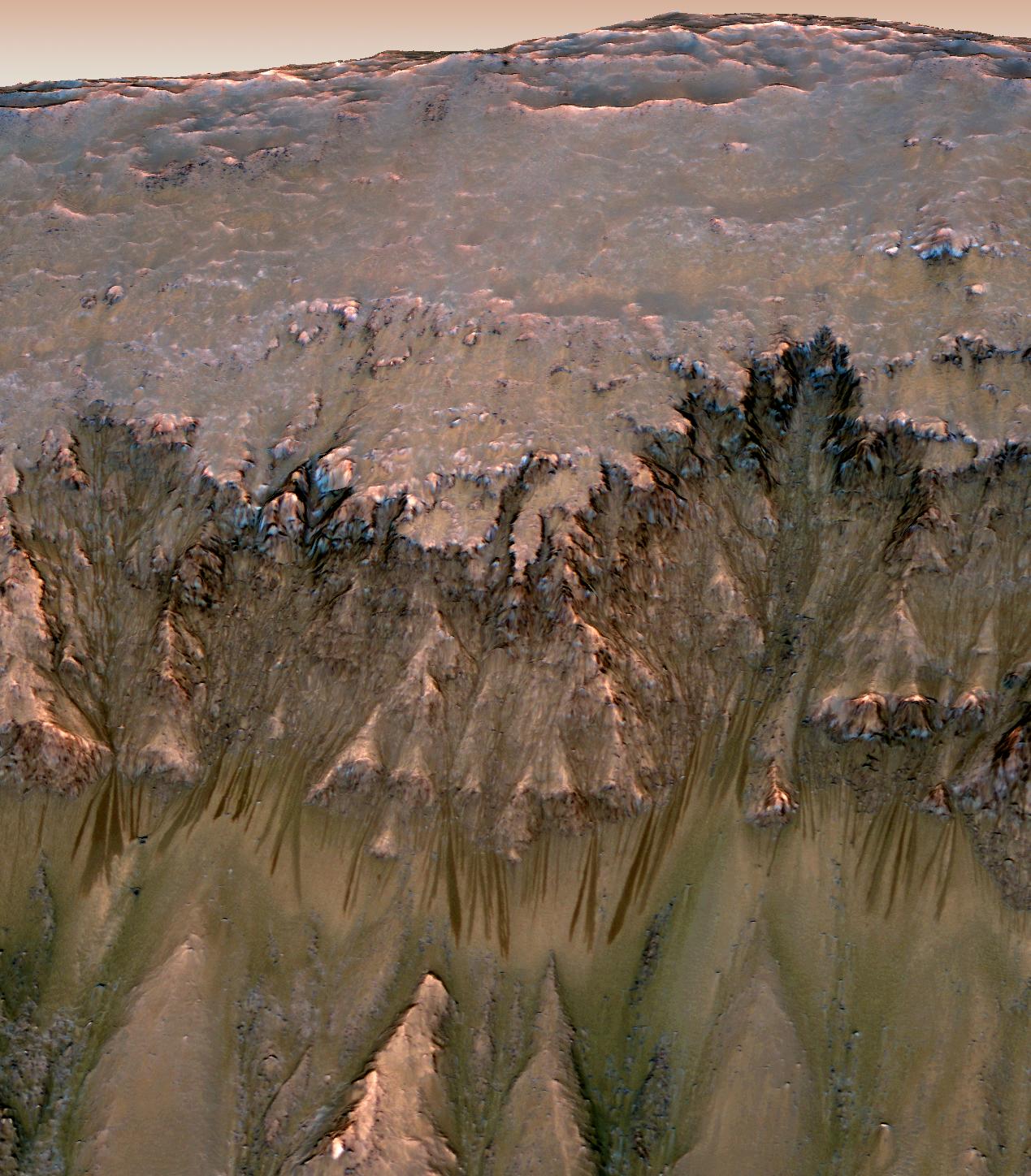
English: Oblique view of warm season flows in Newton Crater.
An image combining orbital imagery with 3-D modeling shows flows that appear in spring and summer on a slope inside Mars' Newton crater. Sequences of observations recording the seasonal changes at this site and a few others with similar flows might be evidence of salty liquid water active on Mars today. Evidence for that possible interpretation is presented in a report by McEwen et al. in the Aug. 5, 2011, edition of Science. This image has been reprojected to show a view of a slope as it would be seen from a helicopter inside the crater, with a synthetic Mars-like sky. The source observation was made May 30, 2011, by the High Resolution Imaging Science Experiment (HiRISE) camera on NASA's Mars Reconnaissance Orbiter. Color has been enhanced. The season was summer at the location, 41.6 degrees south latitude, 202.3 degrees east longitude. The flow features are narrow (one-half to five yards or meters wide), relatively dark markings on steep (25 to 40 degree) slopes at several southern hemisphere locations. Repeat imaging by HiRISE shows the features appear and incrementally grow during warm seasons and fade in cold seasons. HiRISE is operated by the University of Arizona, Tucson, and the instrument was built by Ball Aerospace & Technologies Corp., Boulder, Colo. NASA's Jet Propulsion Laboratory, a division of the California Institute of Technology in Pasadena, manages the Mars Reconnaissance Orbiter for NASA's Science Mission Directorate, Washington. Lockheed Martin Space Systems, Denver, built the spacecraft. Other imagery related to these new findings from the Mars Reconnaissance Orbiter is at http://www.nasa.gov/mission_pages/MRO/multimedia/gallery/gallery-index.html . |
|||||
| 日期 | ||||||
| 來源 | http://photojournal.jpl.nasa.gov/catalog/PIA14479 | |||||
| 作者 | NASA/JPL-Caltech/Univ. of Arizona | |||||
| 授權許可 (重用此檔案) |
|
|||||
| 其他版本 | Newton Crater flows.tif |

| 火星上的位置 | 位於此地的本圖片與其他圖片: Google地图 |
|---|
| 此標籤不表示文件的著作權狀態。任何文件在附有此標籤的同時還需要一個有效的著作權標籤。請參閱許可協議說明頁面以了解更多資訊。 其他語言:
|
檔案歷史
點選日期/時間以檢視該時間的檔案版本。
| 日期/時間 | 縮圖 | 尺寸 | 用戶 | 備註 | |
|---|---|---|---|---|---|
| 目前 | 2019年8月8日 (四) 18:12 | | 1,269 × 1,448(278 KB) | BevinKacon(對話 | 貢獻) | Reverted to version as of 01:01, 5 August 2011 (UTC) actual size from original source |
| 2011年11月1日 (二) 17:55 |  | 2,448 × 2,793(4.53 MB) | Originalwana(對話 | 貢獻) | higher res | |
| 2011年8月5日 (五) 01:01 |  | 1,269 × 1,448(278 KB) | Rrburke(對話 | 貢獻) |
無法覆蓋此檔案。
檔案用途
下列3個頁面有用到此檔案:
全域檔案使用狀況
以下其他 wiki 使用了這個檔案:
- ca.wikipedia.org 的使用狀況
- cs.wikipedia.org 的使用狀況
- en.wikipedia.org 的使用狀況
- es.wikipedia.org 的使用狀況
- fr.wikipedia.org 的使用狀況
- hu.wikipedia.org 的使用狀況
- it.wikipedia.org 的使用狀況
- sk.wikipedia.org 的使用狀況
- tr.wikipedia.org 的使用狀況
- zh.wikipedia.org 的使用狀況