File:OcupaciónGriegaDeAlbania19401941.svg
Jump to navigation
Jump to search

Size of this PNG preview of this SVG file: 600 × 600 pixels. Other resolutions: 240 × 240 pixels | 480 × 480 pixels | 768 × 768 pixels | 1,024 × 1,024 pixels | 2,048 × 2,048 pixels | 1,700 × 1,700 pixels.
Original file (SVG file, nominally 1,700 × 1,700 pixels, file size: 235 KB)
Captions
Captions
Add a one-line explanation of what this file represents
| Description |
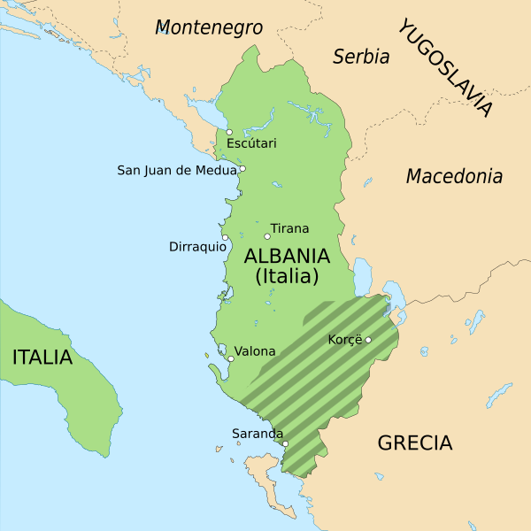
Español: Máximo avance de los ejércitos griegos en Albania durante la Segunda Guerra Mundial (invierno de 1940-1941).
English: Deepest penetration of Greek army in Albanian territory during the Italian-Greek campaign in WWII (winter 1940-1941). |
| Date | (UTC) |
| Source | |
| Author |
|
| Other versions |
Derivative works of this file: GranAlbania1941.svg
|

| This is a retouched picture, which means that it has been digitally altered from its original version. Modifications: spanish version and turned into svg. The original can be viewed here: Albania Greek occupation.png:
|
I, the copyright holder of this work, hereby publish it under the following licenses:
This image is in the public domain because it contains materials that originally came from the United States Central Intelligence Agency's World Factbook.
|
 |
| I, the copyright holder of this work, release this work into the public domain. This applies worldwide. In some countries this may not be legally possible; if so: I grant anyone the right to use this work for any purpose, without any conditions, unless such conditions are required by law. |
You may select the license of your choice.
Original upload log
[edit]
This image is a derivative work of the following images:
- File:Albania_Greek_occupation.png licensed with PD-USGov-CIA-WF, PD-self
- 2006-06-25T18:03:53Z Guss 330x355 (17811 Bytes) Greek occuption of Albania November 1940 - March 1941
Uploaded with derivativeFX
File history
Click on a date/time to view the file as it appeared at that time.
| Date/Time | Thumbnail | Dimensions | User | Comment | |
|---|---|---|---|---|---|
| current | 07:47, 10 July 2021 | | 1,700 × 1,700 (235 KB) | Rowanwindwhistler (talk | contribs) | Names in Spanish, fake text |
| 10:29, 28 October 2016 |  | 1,700 × 1,700 (205 KB) | Rowanwindwhistler (talk | contribs) | https://en.wikipedia.org/wiki/Wikipedia:WikiProject_Maps/Conventions Fake text added | |
| 10:18, 28 February 2010 |  | 1,700 × 1,700 (146 KB) | Rowanwindwhistler (talk | contribs) | {{Information |Description={{es|1=Máximo avance de los ejércitos griegos en Albania durante la Segunda Guerra Mundial (invierno de 1940-1941).}} {{en|1=Deepest penetration of Greek army in Albanian territory during the Italin-Greek campaign in WWII (win |
You cannot overwrite this file.
File usage on Commons
The following 7 pages use this file:
- Atlas of World War II
- User:Magog the Ogre/Maps of conflicts/2016 October
- User:Magog the Ogre/Maps of conflicts/2021 July
- User:Magog the Ogre/Multilingual legend/2021 July 1-10
- User:Sanandros/ogre/secret intelligence/2016 October 21-31
- File:GranAlbania1941.svg
- File:OcupaciónGriegaDeAlbania 1940-1941-hu.svg
File usage on other wikis
The following other wikis use this file:
- Usage on ast.wikipedia.org
- Usage on ca.wikipedia.org
- Usage on es.wikipedia.org