File:Oder-neisse.gif
跳至導覽
跳至搜尋
預覽大小:800 × 518 像素。 其他解析度:320 × 207 像素 | 640 × 414 像素 | 827 × 535 像素。
原始檔案 (827 × 535 像素,檔案大小:25 KB,MIME 類型:image/gif)
說明
說明
添加單行說明來描述出檔案所代表的內容

|
This map has been uploaded by Electionworld from en.wikipedia.org to enable the |
摘要
[編輯]

|
本圖片是以PNG、GIF或JPEG格式上傳。然而,其中包含的資料或訊息,應該重新建立成可縮放向量圖形(SVG)檔案,以更有效率或更準確的方式儲存。如有可能,請上傳本圖片的SVG格式版本。在上傳之後,請修改維基各姊妹計畫中所有使用舊版圖片的條目(列在圖像連結章節中),替換為新版圖片,並在舊圖片的描述頁中加入{{Vector version available|新圖片名稱.svg}}模板,同時移除本模板。
|
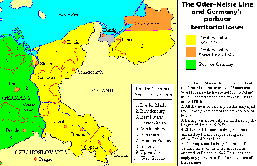
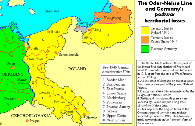
Map by User:Adam Carr, August 2006
授權條款
[編輯]
我,本作品的著作權持有者,決定用以下授權條款發佈本作品:

|
已授權您依據自由軟體基金會發行的無固定段落、封面文字和封底文字GNU自由文件授權條款1.2版或任意後續版本,對本檔進行複製、傳播和/或修改。該協議的副本列在GNU自由文件授權條款中。 |
| 此檔案採用共享創意 姓名標示-相同方式分享 3.0 未在地化版本授權條款。 | ||
| ||
| 已新增授權條款標題至此檔案,作為GFDL授權更新的一部份。 |
您可以選擇您需要的授權條款。
檔案歷史
點選日期/時間以檢視該時間的檔案版本。
| 日期/時間 | 縮圖 | 尺寸 | 用戶 | 備註 | |
|---|---|---|---|---|---|
| 目前 | 2011年8月18日 (四) 22:32 | | 827 × 535(25 KB) | Ras67(對話 | 貢獻) | cropped |
| 2009年7月24日 (五) 11:48 |  | 847 × 552(28 KB) | Botaurus(對話 | 貢獻) | korr. Elbling --> Elbing | |
| 2006年12月22日 (五) 22:27 |  | 847 × 552(28 KB) | Electionworld(對話 | 貢獻) | {{ew|en|Adam Carr}} == Summary == Map by User:Adam Carr, August 2006 == Licensing == {{GFDL-self}} |
無法覆蓋此檔案。
檔案用途
下列2個頁面有用到此檔案:
全域檔案使用狀況
以下其他 wiki 使用了這個檔案:
- ar.wikipedia.org 的使用狀況
- az.wikipedia.org 的使用狀況
- ca.wikipedia.org 的使用狀況
- cs.wikipedia.org 的使用狀況
- cy.wikipedia.org 的使用狀況
- da.wikipedia.org 的使用狀況
- de.wikipedia.org 的使用狀況
- el.wikipedia.org 的使用狀況
- en.wikipedia.org 的使用狀況
- Polish Corridor
- Potsdam Conference
- German reunification
- End of World War II in Europe
- Territorial changes of Poland immediately after World War II
- Reconstruction of Germany
- Demographic estimates of the flight and expulsion of Germans
- User:Adam Carr/My archive of original cartographic contributions
- Talk:Flight and expulsion of Germans (1944–1950)/Archive 8
- Territorial evolution of Germany
- Talk:Wolf's Lair
- Timeline of World War II (1945–1991)
- Recovered Territories
- Commission for the Determination of Place Names
- Oder–Neisse line
- Abolition of Prussia
- User:Chickstarr404/Gather lists/12545 – "Exorcising Hitler"
- August 1970
- Wikipedia:Reference desk/Archives/Humanities/2020 November 3
- User:Falcaorib/Germany and Prussia
- es.wikipedia.org 的使用狀況
- fa.wikipedia.org 的使用狀況
- fi.wikipedia.org 的使用狀況
- fr.wikipedia.org 的使用狀況
- fy.wikipedia.org 的使用狀況
- gl.wikipedia.org 的使用狀況
- it.wikipedia.org 的使用狀況
- ja.wikipedia.org 的使用狀況
檢視此檔案的更多全域使用狀況。