File:Odoacer 480ad.jpg

Originaldatei (900 × 545 Pixel, Dateigröße: 701 KB, MIME-Typ: image/jpeg)
Bildtexte
Kurzbeschreibungen

|
Dieses Bild des Typs Historical map sollte als Vektorgrafik im SVG-Format neu erstellt werden. Vektorformate haben zahlreiche Vorteile; weitere Information unter Commons:Media for cleanup. Wenn dir eine SVG-Version dieses Bildes vorliegt, so lade diese bitte hoch. Nach dem Hochladen der Datei ist diese Vorlage auf der aktuellen Bildbeschreibungsseite durch die Vorlage {{Vector version available}}, oder kürzer {{Vva}}, zu ersetzen. Es ist empfohlen die neue SVG-Datei „Odoacer 480ad.svg“ zu nennen – dann benötigt die Vorlage vector version available (bzw. vva) keinen Parameter.
|


Beschreibung[Bearbeiten]
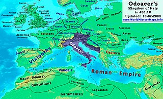
| Beschreibung | Odoacer's Kingdom of Italy in 480 AD. |
| Datum | |
| Quelle | Eigenes Werk |
| Urheber | Thomas Lessman (Contact!) |
| Genehmigung (Weiternutzung dieser Datei) |
Ich, der Urheber dieses Werkes, veröffentliche es unter der folgenden Lizenz: Diese Datei ist unter der Creative-Commons-Lizenz „Namensnennung – Weitergabe unter gleichen Bedingungen 3.0 nicht portiert“ lizenziert.
|
| Andere Versionen | See Below |
Map Summary[Bearbeiten]
Original Source URL: http://www.thomaslessman.com/History/images/East-Hem_480ad.jpg or www.WorldHistoryMaps.info
This map of the Kingdom of Odoacer in 480 AD is a zoomed-in version of Thomas Lessman's map of the East-Hem 480 AD, also available at www.WorldHistoryMaps.info.
The highlighted areas represent Odoacer's Kingdom of Italy, after the capture of Italy (476), conquest of Sicily from the Vandals (477) and the annexation of Dalmatia after the assassination of Emperor Julius Nepos (480).
Map Source References[Bearbeiten]
Remember, sources often conflict with each other. This map is only as accurate as the information that is available to me. To report any errors or to help further this work, please click here, or email Thomas Lessman at talessman@yis.us
References for information contained in this map:
Other Maps by Thomas Lessman[Bearbeiten]
| Maps of the eastern hemisphere showing history
Bold dates are available on Wikimedia or Wikipedia. | ||
| Primeval | ||
| Ancient
|
·| 600 BC | 550 BC | 527 BC | 500 BC |
400 BC | ·| 1 AD | 50 AD | 100 AD | 200 AD | 300 AD | | |
| Medieval |
·| 500 AD | 565 AD | 600 AD | 700 AD | | |
| Modern |
·| 1500 AD | · * For historical maps of the whole world, | |
Dateiversionen
Klicke auf einen Zeitpunkt, um diese Version zu laden.
| Version vom | Vorschaubild | Maße | Benutzer | Kommentar | |
|---|---|---|---|---|---|
| aktuell | 19:50, 23. Okt. 2022 | | 900 × 545 (701 KB) | Gyalu22 (Diskussion | Beiträge) | Reverted bad faith edit. The Westermanns Atlas doesn't show the Carpi |
| 16:05, 15. Sep. 2015 |  | 900 × 545 (727 KB) | Spiridon Ion Cepleanu (Diskussion | Beiträge) | Details about the low-Danube according with H.E.Stier's (dir.) Grosser Atlas zur Weltgeschichte, Westermann 1985. | |
| 21:40, 2. Okt. 2008 |  | 900 × 545 (701 KB) | Talessman (Diskussion | Beiträge) | {{Information |Description= |Source= |Date= |Author= |Permission= |other_versions= }} | |
| 10:29, 10. Mai 2008 |  | 1.402 × 1.023 (380 KB) | Talessman (Diskussion | Beiträge) | {{Information |Description=<big>'''The Odoacer's Kingdom of Italy in 477 AD.'''</big> |Source=Self-made |Author=Thomas Lessman |Permission={{self|cc-by-sa-3.0}} }} |
Du kannst diese Datei nicht überschreiben.
Dateiverwendung
Die folgenden 2 Seiten verwenden diese Datei:
Globale Dateiverwendung
Die nachfolgenden anderen Wikis verwenden diese Datei:
- Verwendung auf azb.wikipedia.org
- Verwendung auf ba.wikipedia.org
- Verwendung auf bg.wikipedia.org
- Verwendung auf br.wikipedia.org
- Verwendung auf ca.wikipedia.org
- Verwendung auf de.wikipedia.org
- Verwendung auf el.wikipedia.org
- Verwendung auf en.wikipedia.org
- Verwendung auf es.wikipedia.org
- Verwendung auf eu.wikipedia.org
- Verwendung auf fi.wikipedia.org
- Verwendung auf fr.wikipedia.org
- Verwendung auf fy.wikipedia.org
- Verwendung auf hy.wikipedia.org
- Verwendung auf ia.wikipedia.org
- Verwendung auf it.wikipedia.org
- Verwendung auf ja.wikipedia.org
- Verwendung auf ko.wikipedia.org
- Verwendung auf li.wikipedia.org
- Verwendung auf lmo.wikipedia.org
- Verwendung auf lt.wikipedia.org
- Verwendung auf lv.wikipedia.org
- Verwendung auf nds.wikipedia.org
- Verwendung auf nl.wikipedia.org
- Verwendung auf pl.wikipedia.org
Weitere globale Verwendungen dieser Datei anschauen.
- Maps of regions showing history by year-spans
- Maps of the world showing history
- Maps of the Roman Empire
- Maps of the Byzantine Empire
- Maps of the European Antiquity
- Maps of historical states of Italy
- Maps of 5th-century Africa
- Maps of the Kingdom of Odoacer
- Maps of 5th-century Europe
- Romania in the 5th century
- Maps of the Suebi
- Maps of the Heruli
- Modifications of the history maps by Thomas A. Lessmann
- Maps showing 480