File:Oil Slick in the Gulf of Mexico May 18th View (4621693252).jpg

Original file (2,200 × 3,000 pixels, file size: 1.28 MB, MIME type: image/jpeg)
Captions
Captions
Summary
[edit].jpg&action=edit§ion=1)
| Description |
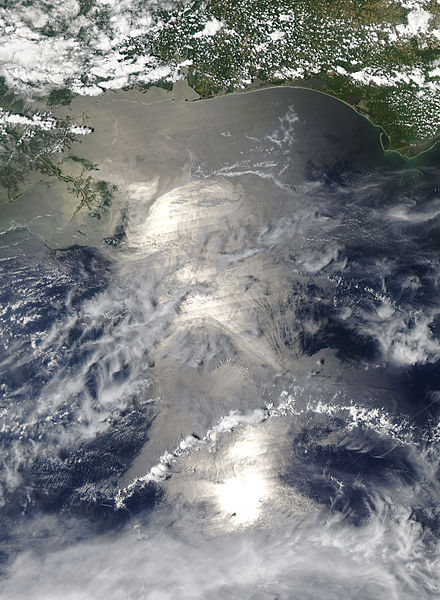
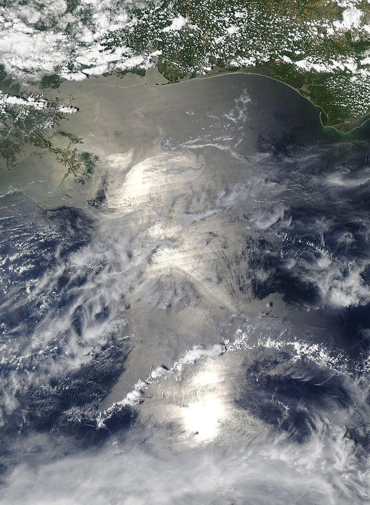
NASA satellite image acquired May 18, 2010 at 19:00 UTC NASA's Aqua Satellite Sees Sunglint on Gulf Oil Slick At 3 p.m. EDT on May 18, NASA's Aqua satellite swept over the Gulf of Mexico oil spill from its vantage point in space and the Moderate Resolution Imaging Spectroradiometer instrument captured sunglint in a visible image of the spill. The visible image showed three bright areas of sunglint within the area of the gray-beige colored spill. Sunglint is a mirror-like reflection of the sun off the water's surface. In calm waters, the rounded image of the sun would be seen in a satellite image. However, the waves in the Gulf blurred the reflection and created an appearance of three bright areas in a line on the ocean's surface. According to the May 18 National Oceanic and Atmospheric Administration (NOAA) web update of the Deepwater Horizon incident, "satellite imagery on May 17 indicated that the main bulk of the oil is dozens of miles away from the Loop Current, but that a tendril of light oil has been transported down close to the Loop Current." The May 18 NOAA update also noted that "NOAA extended the boundaries of the closed fishing area in the Gulf into the northern portion of the loop current as a precautionary measure to ensure seafood from the Gulf will remain safe for consumers. The closed area is now slightly less than 19 percent of the Gulf of Mexico federal waters." To learn more go to: www.nasa.gov/topics/earth/features/oil-creep.html
|
| Date | |
| Source | Oil Slick in the Gulf of Mexico May 18th View |
| Author | NASA Goddard Space Flight Center from Greenbelt, MD, USA |
Licensing
[edit].jpg&action=edit§ion=2)
- You are free:
- to share – to copy, distribute and transmit the work
- to remix – to adapt the work
- Under the following conditions:
- attribution – You must give appropriate credit, provide a link to the license, and indicate if changes were made. You may do so in any reasonable manner, but not in any way that suggests the licensor endorses you or your use.
| This image was originally posted to Flickr by NASA Goddard Photo and Video at https://www.flickr.com/photos/24662369@N07/4621693252. It was reviewed on 19 September 2014 by FlickreviewR and was confirmed to be licensed under the terms of the cc-by-2.0. |
| This file is in the public domain in the United States because it was solely created by NASA. NASA copyright policy states that "NASA material is not protected by copyright unless noted". (See Template:PD-USGov, NASA copyright policy page or JPL Image Use Policy.) | ||
 |
Warnings:
|
File history
Click on a date/time to view the file as it appeared at that time.
| Date/Time | Thumbnail | Dimensions | User | Comment | |
|---|---|---|---|---|---|
| current | 02:13, 19 September 2014 | | 2,200 × 3,000 (1.28 MB) | Geo Swan (talk | contribs) | Transferred from Flickr via Flickr2commons |
You cannot overwrite this file.
File usage on Commons
There are no pages that use this file.
.jpg&oldid=918423495)