File:Oiunyt.jpg
Jump to navigation
Jump to search

Size of this preview: 800 × 533 pixels. Other resolutions: 320 × 213 pixels | 640 × 427 pixels | 1,024 × 683 pixels | 1,280 × 853 pixels | 2,560 × 1,707 pixels | 3,456 × 2,304 pixels.
Original file (3,456 × 2,304 pixels, file size: 11.32 MB, MIME type: image/jpeg)
Captions
Captions
Add a one-line explanation of what this file represents
Summary[edit]
| Description |
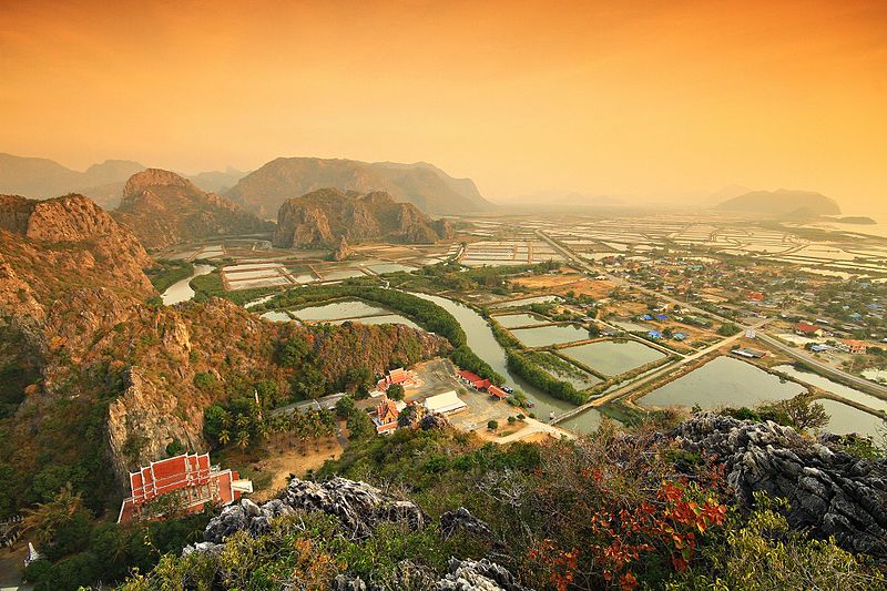
English: Khao Sam Roi Yot National Park Prachuap Khiri Khan Thailand
Khao Sam Roi Yot means "mountain with 300 peaks". The limestone hills are a subrange of the Tenasserim Hills that arise at the shore of the Gulf of Thailand, with the highest elevation being Khao Krachom at 605 m. Between the hills are freshwater marshes. Several of these marshes were converted into shrimp farms, as only 36 km2 of the total 69 km2 of marshes are part of the national park. A portion, 18 km2, of these marshes are scheduled to be declared a Ramsar site.
|
||
| Date | 10 January 2011, 07:14:34 (according to Exif data) | ||
| Source | Own work | ||
| Author | KOSIN SUKHUM |
Licensing[edit]
I, the copyright holder of this work, hereby publish it under the following license:
This file is licensed under the Creative Commons Attribution-Share Alike 4.0 International license.
- You are free:
- to share – to copy, distribute and transmit the work
- to remix – to adapt the work
- Under the following conditions:
- attribution – You must give appropriate credit, provide a link to the license, and indicate if changes were made. You may do so in any reasonable manner, but not in any way that suggests the licensor endorses you or your use.
- share alike – If you remix, transform, or build upon the material, you must distribute your contributions under the same or compatible license as the original.
This image was uploaded as part of Wiki Loves Earth 2016.
|
 |
File history
Click on a date/time to view the file as it appeared at that time.
| Date/Time | Thumbnail | Dimensions | User | Comment | |
|---|---|---|---|---|---|
| current | 18:12, 17 June 2016 | | 3,456 × 2,304 (11.32 MB) | KOSIN SUKHUM (talk | contribs) | Khao Sam Roi Yot National Park Prachuap Khiri Khan Thailand |
| 18:04, 17 June 2016 |  | 1,500 × 1,000 (1.69 MB) | KOSIN SUKHUM (talk | contribs) | User created page with UploadWizard |
You cannot overwrite this file.
File usage on Commons
The following 8 pages use this file:
- User:John Cummings/exhibition/natural
- User:John Cummings/sandboximages5
- Commons:Wiki Loves Earth 2016/Winners
- Commons:Wiki Loves Earth 2016 in Thailand/Final
- Commons:Wiki Loves Earth 2016 in Thailand/First round
- Commons:Wiki Loves Earth 2017 in Bulgaria
- Commons:Wiki Loves Earth 2022 in Thailand
- Commons:Wiki Loves Earth 2023 in Thailand
File usage on other wikis
The following other wikis use this file:
- Usage on az.wikipedia.org
- Usage on en.wikipedia.org
- Usage on eu.wikipedia.org
- Usage on ja.wikipedia.org
- Usage on km.wikipedia.org
- Usage on ml.wikipedia.org
- Usage on mt.wikipedia.org
- Usage on my.wikipedia.org
- Usage on nn.wikipedia.org
- Usage on sv.wikipedia.org
- Usage on th.wikipedia.org
- Usage on tl.wikipedia.org
- Usage on zh.wikipedia.org